DJI Mavic, Air and Mini Drones
Friendly, Helpful & Knowledgeable Community
Join Us Now

Is this kind of warping normal for a mavic air 2?

ThirtyWest

Active Member
Joined
Dec 25, 2021
Messages
31
Reactions
1
Age
54
Location
Houston, TX
So, we went to the highschool football field to see if we could make the math work for an airspace authorization.

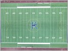
This was taken from 67.2 meters. As you can see the image warps--giving larger angles of endzone visible at the bottom of the picture versus the top.

Is this normal? I have no reason to believe we weren't at gimbal lock looking straight down.
 

Attachments

  • Capture.PNG
    Capture.PNG
    2.6 MB · Views: 166
I think the image is crooked and may be rotated a bit.

I looked at one of my football field pictures and it was square.

I use the 3x3 grid when shooting pictures for a better reference and fly in tripod mode for sensitive movements.
 
Camera definitely needed to be rotated slightly more to the right. Notice how the track lane white lines at the top and bottom of the pic aren't parallel with the bottom of the photo.
 
  • Like
Reactions: MARK (LI)
I thought so too, but the blue extra gaps are at the bottom of both sides. Were it rotated you'd have blue at opposite diagonal corners--not just at the bottom. If you look closely, the goal line is *just* showing even blue a both top corners.

Not quite related, but the reason we were there since I'm trying to see if there is a lense issue: I spent some time reading the math to figure out the AoV so I could know how high to be.

Using FoV = 2 * arctan (diagonal of sensor / (2 * focal length)) gives me:

82.26 = 2 * arctan (8mm / (2 * 4.5mm))

the mavic air 2 says it's 6.4 by 4.8mm which gives 8mm across the diagonal.

so using trig that 82.26 / 2 = 41.63. I know this isn't good because the sensor would need to be almost a square to come up with 82.26 versus the posted value of 84.


But, to back that "wrong" claim up:

It's 150ft from the middle of the field to the goal line.

math says 150ft / tan(41.63) = 168 ft (or, 51.43 m) is the needed height.


I know this is wrong because the shot was taken at 67.2m (220 ft).

If you work the trig backwards that's 34.28 degrees, or 68.57 AoV.


Multiply 68.57 by 1.25 (which is the ratio of the sensors diagonal to horizontal...8 to 6.4) an dyou get 85.7 which is a lot closer to the DJI value (their diagonal value) of 84.
 
Camera definitely needed to be rotated slightly more to the right. Notice how the track lane white lines at the top and bottom of the pic aren't parallel with the bottom of the photo.
I agree it's not straight, but the parallax at the top and bottom are not geometrically sound. the "skinny" ends should be opposites and not both on the right side. Plus, look at the blue endzones. the extra blue is showing at the bottom of each end of the field. Were it rotational would they not be opposite as the camera twisted?
 
So, we went to the highschool football field to see if we could make the math work for an airspace authorization.

This was taken from 67.2 meters. As you can see the image warps--giving larger angles of endzone visible at the bottom of the picture versus the top.

Is this normal? I have no reason to believe we weren't at gimbal lock looking straight down.
Looks like it's not perfectly squared up with the field. Even a little tilt or skew will be really noticeable with that choice of subject (parallel lines). There's also the potential for some interaction with lens distortion. Did you shoot this raw or JPEG? If raw, were lens corrections active in your raw converter?
 
Looks like it's not perfectly squared up with the field. Even a little tilt or skew will be really noticeable with that choice of subject (parallel lines). There's also the potential for some interaction with lens distortion. Did you shoot this raw or JPEG? If raw, were lens corrections active in your raw converter?
it was JPEG. We are just getting accustomed to it.

What kind corrections would be made with RAW?


As has been pointed out, yes it's not perfectly rotated, but the misaligned blue areas are at both bottom corners and not opposites. it's as if the camera were not looking straight down.
 
So, we went to the highschool football field to see if we could make the math work for an airspace authorization.

This was taken from 67.2 meters. As you can see the image warps--giving larger angles of endzone visible at the bottom of the picture versus the top.

Is this normal? I have no reason to believe we weren't at gimbal lock looking straight down.
Use something like a piece of paper against a dark background while the the drone isn’t flying. It’s not necessary to use something so large and far away to test the distortion. There’s so many things that could be wrong when using something that big.
 
Use something like a piece of paper against a dark background while the the drone isn’t flying. It’s not necessary to use something so large and far away to test the distortion.
You mean like place the drone on a table and shoot some poster board across the room?
 
If you upload the txt flight log to DJI Flight Log Viewer | Phantom Help
(there are instruction on that page for retrieving the log) then download and open the csv from the resulting page in a spreadsheet program and look at the columns around column BC /55 you should find details of the gimbal's tilt and roll.
I think these are relative to the gravitational horizontal but will stand correction on that
 
it was JPEG. We are just getting accustomed to it.

What kind corrections would be made with RAW?


As has been pointed out, yes it's not perfectly rotated, but the misaligned blue areas are at both bottom corners and not opposites. it's as if the camera were not looking straight down.
Raw files can have different corrections applied to adjust lens distortion. The wide angle lens on a drone will typically have some amount of distortion that renders straight lines as curved - the drone can adjust this in JPEG, and you can adjust this in the raw file.

See: Distortion (optics) - Wikipedia

If you're trying to get the whole field in a picture, your best bet is to fly a little higher and correct the distortion in post, via Photoshop or Lightroom.
 
Just do jpeg for now.

It’s normal to have lens distortion. What wouldn’t be normal is to have off axis distortion like what you show in your first photo. I actually doubt the lens is off axis. Much more likely the drone wasn’t perfectly center and not looking perfectly straight down but if you want to be sure do the poster on the wall thing
 
If you upload the txt flight log to DJI Flight Log Viewer | Phantom Help
(there are instruction on that page for retrieving the log) then download and open the csv from the resulting page in a spreadsheet program and look at the columns around column BC /55 you should find details of the gimbal's tilt and roll.
I think these are relative to the gravitational horizontal but will stand correction on that
Wow that's an immense amount of data. -89.9 is what it was showing. that's probably as close to "down" as it's going to show
 
Quite a bit of the data is duplicated but it's still handy to know it's there. Occasionally one channel/column is empty whilst its 'partner' contains data. This happens more with the Go & Go4 apps than with the Fly app.
 
Raw files can have different corrections applied to adjust lens distortion. The wide angle lens on a drone will typically have some amount of distortion that renders straight lines as curved - the drone can adjust this in JPEG, and you can adjust this in the raw file.

See: Distortion (optics) - Wikipedia

If you're trying to get the whole field in a picture, your best bet is to fly a little higher and correct the distortion in post, via Photoshop or Lightroom.
I've got photoshop; how is this adjusted in a raw file? Are we talking simple image transformations?
 
I've got photoshop; how is this adjusted in a raw file? Are we talking simple image transformations?
It’s not that kind of distortion. You can fix it easily in Photoshop but are you trying to figure out if there’s something wrong with your lens or how to fix this one photo?
 
It’s not that kind of distortion. You can fix it easily in Photoshop but are you trying to figure out if there’s something wrong with your lens or how to fix this one photo?
Well, it's starting to sound like distortion that i need to account for.

So, I'd like to learn about adjusting RAW images in photoshop.
 
Well, it's starting to sound like distortion that i need to account for.

So, I'd like to learn about adjusting RAW images in photoshop.
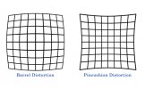
The type of distortion @adcimagery is referring to is barrel distortion or pincushion distortion. If you had taken this photo in raw and had ether of these distortion patterns you could fix it using using Camera Raw in Photoshop but you took it using jpeg so distortion corrections were already applied and your photo doesn’t exhibit any noticeable amount of either pattern.

D51F2B25-1304-4D4D-A577-F902171D43D6.jpeg
 

DJI Drone Deals

New Threads

Forum statistics

Threads
134,498
Messages
1,595,654
Members
163,022
Latest member
Freakazoid
Want to Remove this Ad? Simply login or create a free account