I couldn't find a simple and modern Mavic Air answer to the conundrum below, despite a wide search.
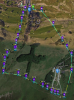
Simply, I had made a Litchi mission to stay within 30m of the ground as the drone climbed and then descended a hill. After I hit the 'play' button and the mission was 100% transmitted to the aircraft, a red message appeared in Litchi saying, "Aircraft altitude too high", and the mission did not start. I assumed that I had made an error in the programme (perhaps had left off an "Above ground" checkbox in a waypoint?) but I couldn't find the problem, so I returned home and started again. New blank Litchi page, new mission, similar route... identical result: "Aircraft altitude too high".
The answer was simply to quit Litchi, start DJI Go 4, and change my maximum height. It was a (UK legal) 120m, but I had to set it to 230m, even though it never went more that 30m above the ground:

At its highest point, the drone was 187m above the start point, which itself was 30m in the air. Therefore the drone would be 187+30m above the ground - 217m. (I added another 13m for the sake of "roundness")
There have been other posts on this matter, but they seem to have started from different places.
As an aside, despite wonderful weather, the film from this mission was not great - somehow the Mavic Air seemed shakier than usual. The wind was not excessive, so I am wondering whether the rates of ascent/descent I was asking for had strained the performance capabilities of the little craft?
Simply, I had made a Litchi mission to stay within 30m of the ground as the drone climbed and then descended a hill. After I hit the 'play' button and the mission was 100% transmitted to the aircraft, a red message appeared in Litchi saying, "Aircraft altitude too high", and the mission did not start. I assumed that I had made an error in the programme (perhaps had left off an "Above ground" checkbox in a waypoint?) but I couldn't find the problem, so I returned home and started again. New blank Litchi page, new mission, similar route... identical result: "Aircraft altitude too high".
The answer was simply to quit Litchi, start DJI Go 4, and change my maximum height. It was a (UK legal) 120m, but I had to set it to 230m, even though it never went more that 30m above the ground:
At its highest point, the drone was 187m above the start point, which itself was 30m in the air. Therefore the drone would be 187+30m above the ground - 217m. (I added another 13m for the sake of "roundness")
There have been other posts on this matter, but they seem to have started from different places.
As an aside, despite wonderful weather, the film from this mission was not great - somehow the Mavic Air seemed shakier than usual. The wind was not excessive, so I am wondering whether the rates of ascent/descent I was asking for had strained the performance capabilities of the little craft?