DJI Mavic, Air and Mini Drones
Friendly, Helpful & Knowledgeable Community
Join Us Now

Litchi Waypoint Mission to Mavic 3 Waypoint Mission converter

DJ Wes

Well-Known Member
Joined
Feb 6, 2019
Messages
394
Reactions
804
Location
Springdale, AR, USA
Site
www.litchiutilities.com
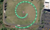
I have completed my “Litchi Waypoint Mission to Mavic 3 Waypoint Mission converter.

With this web application, one can design a waypoint mission from the comfort of your office on a large monitor using Litchi’s Mission Hub then convert that mission to one that can be flown with a Mavic 3.
Capture.JPG

Litchi missions can be exported as CSV files. These CSV files store most of the important parameters of a waypoint mission. DJI’s Mavic 3 stores waypoint missions in a KMZ file in the flying device (phone, tablet or controller). However, because DJI did not design missions to be imported or exported to or from their flying device, there are a few extra steps involved in getting this process to work. As a result, these steps may be more involved than what a casual user may want to attempt. Read on to find out more.

Fellow forum member @zAvi has provided a number of Mavic 3 waypoint missions for me to examine and has devised a way to import and export missions to and from the Mavic 3. His instructions for doing so are available from the instructions of this web application.

There are a few important things to consider when converting waypoint missions between Litchi and the Mavic 3.
  • Litchi uses a B-Spline to generate a flight path defined by waypoints. The Mavic 3 uses a Bézier curve to generate a flight path defined by waypoints. B-Splines do not (in general) go through their control points. Bézier curves do go through their control points. As a result, even though the waypoints are the same, the converted mission flight path will not be exactly the same.
  • The Mavic 3 supports some camera actions that are not available in Litchi. For example, in the Mavic 3 one can create a “Zoom” action. Litchi does not support this action.
  • So far, I have only had access to Mavic 3 missions with metric units of measurement. Therefor, only metric units are currently supported. I will add imperial units as soon as I am provided an example Mavic 3 mission file with imperial units.
The following two converters (as well as the Spiral, Panorama, Droneception, and AirData converters):
  • Mavic 3 Waypoint Mission To Litchi Waypoint Mission
  • Litchi Waypoint Mission To Mavic 3 Waypoint Mission
are available here:

 
Last edited:
Do you expect this is working with a M3E/M3t also ?

Until now i thought /hoped i would just have to export the KML from Litchie and convert it into KMZ with QGIS or Googleearth. Won't that work also ?
 
I have completed my “Litchi Waypoint Mission to Mavic 3 Waypoint Mission converter.

With this web application, one can design a waypoint mission from the comfort of your office on a large monitor using Litchi’s Mission Hub then convert that mission to one that can be flown with a Mavic 3.

View attachment 160898

Litchi missions can be exported as CSV files. These CSV files store most of the important parameters of a waypoint mission. DJI’s Mavic 3 stores waypoint missions in a KMZ file in the flying device (phone, tablet or controller). However, because DJI did not design missions to be imported or exported to or from their flying device, there are a few extra steps involved in getting this process to work. As a result, these steps may be more involved than what a casual user may want to attempt. Read on to find out more.

Fellow forum member @zAvi has provided a number of Mavic 3 waypoint missions for me to examine and has devised a way to import and export missions to and from the Mavic 3. His instructions for doing so are available from the instructions of this web application.

There are a few important things to consider when converting waypoint missions between Litchi and the Mavic 3.
  • Litchi uses a B-Spline to generate a flight path defined by waypoints. The Mavic 3 uses a Bézier curve to generate a flight path defined by waypoints. B-Splines do not (in general) go through their control points. Bézier curves do go through their control points. As a result, even though the waypoints are the same, the converted mission flight path will not be exactly the same.
  • The Mavic 3 supports some camera actions that are not available in Litchi. For example, in the Mavic 3 one can create a “Zoom” action. Litchi does not support this action.
  • So far, I have only had access to Mavic 3 missions with metric units of measurement. Therefor, only metric units are currently supported. I will add imperial units as soon as I am provided an example Mavic 3 mission file with imperial units.
The following two converters (as well as the Spiral, Panorama, Droneception, and AirData converters):
  • Mavic 3 Waypoint Mission To Litchi Waypoint Mission
  • Litchi Waypoint Mission To Mavic 3 Waypoint Mission
are available here:

The one thing omitted from your OP is to remind waypoint mission makers that before migrating to a Mavic device ,.. you should learn how (quite easy) to virtually fly your newly created (Litchi) mission in Google Earth. This is an invaluable way to review, refine and (save!) your UAV and the story you're trying to capture without flying into a miscalculated hillside, iffy altitude reported by Litchi/GE, or missing a filming opportunity via an airborne perspective. (sorry for the run-on sentence here).

Designing waypoint missions is an art and speaks to the very purpose of a UAV IMNSHO. Don't get me wrong, manual flying is fun and the skills needed to do so are critical as well.
 
Last edited:
Do you expect this is working with a M3E/M3t also ?

Until now i thought /hoped i would just have to export the KML from Litchie and convert it into KMZ with QGIS or Googleearth. Won't that work also ?
There are a few model-specific items in the KMZ data. I don't know what DJI uses them for. I would like to see an M3E/M3T KMZ file to compare.

I don't see how how you would be able to convert a Litchi KML file into a KMZ file appropriate for a DJI drone. I would recommend that you examine one of each. Let me know if you have any luck.
 
  • Like
Reactions: michelbaudry
Surprised more people aren't talking about this. I've never built a Litchi mission file before, but I am definitely going to give all of this a try.
 
  • Like
Reactions: DJ Wes
Good afternoon,
I would like to know if is it possible to plan the mission in file .csv. Is it possible to program the camera for taking photo in step every 2/3 secunds and conversion it to file .kmz?
 
As the regulatory sun appears to be setting on my Phantom 4 Pro I am eagerly following this thread. I am user of Google Earth/Litchi Virtual Mission for all mission planning. Being able to virtually see what is in the field of view throughout the mission is an invaluable tool.

I understand, the issue between B-Spline (Litchi) vs DJI (Bessier) and wonder how this will functionally impact the how the eventual video looks? My guess is the DJI (Bessier) mission videos will look more abrupt at the vertices as the aircraft makes a sudden change in course.

Don
 
I have completed my “Litchi Waypoint Mission to Mavic 3 Waypoint Mission converter.

With this web application, one can design a waypoint mission from the comfort of your office on a large monitor using Litchi’s Mission Hub then convert that mission to one that can be flown with a Mavic 3.

View attachment 160898

Litchi missions can be exported as CSV files. These CSV files store most of the important parameters of a waypoint mission. DJI’s Mavic 3 stores waypoint missions in a KMZ file in the flying device (phone, tablet or controller). However, because DJI did not design missions to be imported or exported to or from their flying device, there are a few extra steps involved in getting this process to work. As a result, these steps may be more involved than what a casual user may want to attempt. Read on to find out more.

Fellow forum member @zAvi has provided a number of Mavic 3 waypoint missions for me to examine and has devised a way to import and export missions to and from the Mavic 3. His instructions for doing so are available from the instructions of this web application.

There are a few important things to consider when converting waypoint missions between Litchi and the Mavic 3.
  • Litchi uses a B-Spline to generate a flight path defined by waypoints. The Mavic 3 uses a Bézier curve to generate a flight path defined by waypoints. B-Splines do not (in general) go through their control points. Bézier curves do go through their control points. As a result, even though the waypoints are the same, the converted mission flight path will not be exactly the same.
  • The Mavic 3 supports some camera actions that are not available in Litchi. For example, in the Mavic 3 one can create a “Zoom” action. Litchi does not support this action.
  • So far, I have only had access to Mavic 3 missions with metric units of measurement. Therefor, only metric units are currently supported. I will add imperial units as soon as I am provided an example Mavic 3 mission file with imperial units.
The following two converters (as well as the Spiral, Panorama, Droneception, and AirData converters):
  • Mavic 3 Waypoint Mission To Litchi Waypoint Mission
  • Litchi Waypoint Mission To Mavic 3 Waypoint Mission
are available here:

Very nice work! Quite impressive
 
Good afternoon,
I would like to know if is it possible to plan the mission in file .csv. Is it possible to program the camera for taking photo in step every 2/3 secunds and conversion it to file .kmz?
While taking a photo every n seconds is possible in Litchi, I do not know if that capability exists in Mavic 3 missions. If it is, I would need to see a sample Mavic 3 kmz file to see how they configure it.
 
While taking a photo every n seconds is possible in Litchi, I do not know if that capability exists in Mavic 3 missions. If it is, I would need to see a sample Mavic 3 kmz file to see how they configure it.
Like member Coskier above, I too am surprised there is not much action to this thread. I am a former Mavic 2 Pro owner (Sold) and I have a Mavic 3 Classic with one flight on it. I have flown a lot of Litchi Missions on the Mavic 2 Series in the past. I attempted to do some Waypoint Mission planning on the M3 Classic but even with the DJI RC Pro controller and a very good stylus, mission planning on the controller is nothing but a frustration exercise. Let me know if I can help you with anything in the area of flight testing. I would have submitted something sooner here, but I am recovering from total hip replacement surgery. I can fly test missions, both newly designed missions, and my old ones in a park a block from my house. Realistically, I'm probably 2 weeks away from being able to drive my car, as I need clearance from my Surgeon before doing so. Let me know if I can be of any assistance. A PM would be a good way to start and we can go from there. If you would like to see a sample of what I have done in the past, Take a look at my Pardee 2 video here.
 
Last edited:
  • Like
Reactions: DJ Wes
Like member Coskier above, I too am surprised there is not much action to this thread. I am a former Mavic 2 Pro owner (Sold) and I have a Mavic 3 Classic with one flight on it.
For all of the complaining of the lack of an SDK for the Mavic 3 I too am a bit surprised by the sparsity of responses.

I do know that my utility is being used. I have received some feedback from people who have successfully flown converted Litchi missions on their Mavic 3. What I need is for more people to try this utility and then providing feedback even if it is about a failure. I cannot fix something if I don't know that it doesn't work.

I attempted to do some Waypoint Mission planning on the M3 Classic but even with the DJI RC Pro controller and a very good stylus, mission planning on the controller is nothing but a frustration exercise.
Yes. DJI's implementation of waypoint mission planning on the flying device should be considered only a "proof of concept". Nothing beats planning a mission on a large screen from the comfort of your office.
 
I was very interested to read about the attempts to transfer waypoint planning to the Mavic 3. I have gone a slightly different way, but unfortunately not yet successfully to the end.
I open the DJI Fly app on my iPad. With it, you can plan the waypoints very well even without the Mavic 3 connected and also save the file on the iPad.

My problem is how do I get the file created on the iPad onto my RC-Pro controller? I already have the file on the RC-Pro controller via Dropbox, but I don't have the next steps to transfer it to the correct folder on the Android operating system of the controller.

Who can help me with this and give me tips, because this would be a relatively simple way to plan the waypoint planning on an iPad, for example, and then transfer the result to the RC-Pro or RC controller.

I am curious if there are any solutions.

Greetings
Jürgen
Jürgen, the instructions tell you how to do this. You can read them here: Litchi Waypoint Mission to Mavic 3 Waypoint Mission
I have successfully done this once but failed on my second attempt. I am working on my third attempt.

 
I've tested the file tranfer method on Andrrod iOS & DJI RC ..
Hoping to find someone who is using RC Pro to test this method
 
I've tested the file tranfer method on Andrrod iOS & DJI RC ..
Hoping to find someone who is using RC Pro to test this method
I could be your guy, but even though I have DJI Fly on my iPad, when I open camera view it is a blank screen. If you have any insights, I would love to hear them. I also have a Galaxy Tab A, Android tablet but the latest OS will not install on this tablet and I cannot install DJI Fly on this device so another avenue is closed. If you have an idea why I cannot get to the Camera view, please let me know. Is there still a way I could help you test?
 
Do you mean main normal camera view of drone
or
Do you mean camera view whhenn opened waypoints
 
Do you mean main normal camera view of drone
or
Do you mean camera view whhenn opened waypoints
I mean, with DJI Fly opened, you select your drone (DJI Mavic 3 Classic) then in the upper right corner of the screen of the controller, (In this case your iPad screen) you select "Camera View>" and then you have the screen where you can use your Waypoint controls. Mine is blank.
 
Mabye reistall
I was very interested to read about the attempts to transfer waypoint planning to the Mavic 3. I have gone a slightly different way, but unfortunately not yet successfully to the end.
I open the DJI Fly app on my iPad. With it, you can plan the waypoints very well even without the Mavic 3 connected and also save the file on the iPad.

My problem is how do I get the file created on the iPad onto my RC-Pro controller? I already have the file on the RC-Pro controller via Dropbox, but I don't have the next steps to transfer it to the correct folder on the Android operating system of the controller.

Who can help me with this and give me tips, because this would be a relatively simple way to plan the waypoint planning on an iPad, for example, and then transfer the result to the RC-Pro or RC controller.

I am curious if there are any solutions.

Greetings
Jürgen
Hi Iam talking to another guy who also has a RC Pro also looking for help.
He has manged to tranfer files [ not sure how at the moment ]

I dont think you can connect iOS to a RC Pro and read file structure [diff OS]
When I transfer to android I use my Macbook running an App call Android File
Probally something similar for IBM's
Tranfer files to IBM/Mac and the connect to RC Pro
 
I mean, with DJI Fly opened, you select your drone (DJI Mavic 3 Classic) then in the upper right corner of the screen of the controller, (In this case your iPad screen) you select "Camera View>" and then you have the screen where you can use your Waypoint controls. Mine is blank.
Sorry Jeff. I'm still not clear on what screen you are referring to. Is it this one where you press on "Go Fly" to get to the camera view? Perhaps a picture will help us understand.
Capture.JPG
 
Sorry Jeff. I'm still not clear on what screen you are referring to. Is it this one where you press on "Go Fly" to get to the camera view? Perhaps a picture will help us understand.
View attachment 163783
I don't have an Air 2 S but it would be close. The screen that is blank contains the Waypoint controls.
 
Lycus Tech Mavic Air 3 Case

DJI Drone Deals

New Threads

Forum statistics

Threads
131,086
Messages
1,559,701
Members
160,068
Latest member
Bahamaboy242