DJI Mavic, Air and Mini Drones
Friendly, Helpful & Knowledgeable Community
Join Us Now

Litchi Waypoint Mission to Mavic 3 Waypoint Mission converter

Hello there!
I have been following this group and development in order to use Litchi with Mavic 3 for a long time. This last thursday I made my first mapping with the Mavic 3 using Litchi and this amazing converter to waypoint for DJI Fly (Mavic 3).
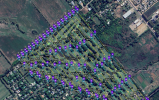
I started planning the mission with Mission Planner (ardupilot) where I made the profile for the Mavic 3 camera and then created the flight lines. I added multiple waypoints in order to "avoid" the Bézier curve of the waypoints of Mavic 3 and try to mantain the straight lines between flight lines. It was a total success!!
I used camera timer inverval for the photos to achieve a 85% inline overlap with success. I am really happy with this development you did and with a lot of more calculations (mission planner) it is possible to do some mapping.
I attach captures of the mission in Litchi and in DJI Fly.
Thank you all for this great idea.
Regards!
Pablo
 

Attachments

  • 1a.PNG
    1a.PNG
    2.5 MB · Views: 17
  • WhatsApp Image 2023-07-22 at 19.17.43.jpeg
    WhatsApp Image 2023-07-22 at 19.17.43.jpeg
    146.8 KB · Views: 17
In these days I want to do some missions in mountains with the litchi converter to Mavic 3. I read the following note at the litchi waypoint to mavic 3 webpage:
  • For those using the "Above Ground" option in Litchi's Mission Hub, it is important to know that when this option is selected, Litchi only writes the "above ground" height into the CSV file as opposed to the "above take-off" height. As a result, a Mavic 3 mission converted from a Litchi mission will not follow the height of the terrain as it would in the Litchi app.
Since I created a lot of waypoints using the above ground feature, when I converted the mission and then uploaded to DJI Fly, the altitudes for each waypoints are correct and the same value that appears at Litchi Mission hub.
What does theprevious statement refer to?

Lets try this example: If at Litchi Mission Hub I set an altitude of 100m ABOVE ground and the absolute altitude at Litchi shows 150masl... then after convertion to DJI Fly it shows the same altitude of 150m and the waypoint using the map... Then after take off, when its time to go to that waypoing it will climb to:
a) 150m above sea?
b) 150m above the take off point?

Thank you in advance and sorry for my english.
Regards,
Pablo
 
  • For those using the "Above Ground" option in Litchi's Mission Hub, it is important to know that when this option is selected, Litchi only writes the "above ground" height into the CSV file as opposed to the "above take-off" height. As a result, a Mavic 3 mission converted from a Litchi mission will not follow the height of the terrain as it would in the Litchi app.
Since I created a lot of waypoints using the above ground feature, when I converted the mission and then uploaded to DJI Fly, the altitudes for each waypoints are correct and the same value that appears at Litchi Mission hub.
What does theprevious statement refer to?
I have recently enabled the handling of the "Above Gound" option in my converter. I forgot to remove that note you quoted. I have now removed that warning about the "Above Ground" option because it no longer applies.

Thanks for bringing that to my attention.
 
  • Like
Reactions: Facherty
I'll ask this here since it seems to be the most fitting of the converter threads:

Do actions like intervall photo (time lapse) work?
 
I'll ask this here since it seems to be the most fitting of the converter threads:

Do actions like intervall photo (time lapse) work?
Traditional waypoint actions such as "Take Photo", "Start Recording", "Tilt Camera", etc. are part of the conversion process but there is no "interval photo" action for hyperlapse missions. You can still create and convert a mission then initiate a series of interval photos manually as the mission starts.
 
  • Like
Reactions: honkihonk
Traditional waypoint actions such as "Take Photo", "Start Recording", "Tilt Camera", etc. are part of the conversion process but there is no "interval photo" action for hyperlapse missions. You can still create and convert a mission then initiate a series of interval photos manually as the mission starts.
Thank you. Is the lack of timelapse actions something that can be changed by the Capability.json files?
 
I have completed my “Litchi Waypoint Mission to Mavic 3 Waypoint Mission converter.

With this web application, one can design a waypoint mission from the comfort of your office on a large monitor using Litchi’s Mission Hub then convert that mission to one that can be flown with a Mavic 3.

View attachment 160898

Litchi missions can be exported as CSV files. These CSV files store most of the important parameters of a waypoint mission. DJI’s Mavic 3 stores waypoint missions in a KMZ file in the flying device (phone, tablet or controller). However, because DJI did not design missions to be imported or exported to or from their flying device, there are a few extra steps involved in getting this process to work. As a result, these steps may be more involved than what a casual user may want to attempt. Read on to find out more.

Fellow forum member @zAvi has provided a number of Mavic 3 waypoint missions for me to examine and has devised a way to import and export missions to and from the Mavic 3. His instructions for doing so are available from the instructions of this web application.

There are a few important things to consider when converting waypoint missions between Litchi and the Mavic 3.
  • Litchi uses a B-Spline to generate a flight path defined by waypoints. The Mavic 3 uses a Bézier curve to generate a flight path defined by waypoints. B-Splines do not (in general) go through their control points. Bézier curves do go through their control points. As a result, even though the waypoints are the same, the converted mission flight path will not be exactly the same.
  • The Mavic 3 supports some camera actions that are not available in Litchi. For example, in the Mavic 3 one can create a “Zoom” action. Litchi does not support this action.
  • So far, I have only had access to Mavic 3 missions with metric units of measurement. Therefor, only metric units are currently supported. I will add imperial units as soon as I am provided an example Mavic 3 mission file with imperial units.
The following two converters (as well as the Spiral, Panorama, Droneception, and AirData converters):
  • Mavic 3 Waypoint Mission To Litchi Waypoint Mission
  • Litchi Waypoint Mission To Mavic 3 Waypoint Mission
are available here:

Just came across this thread and found it interesting. As a user of Litchi with my Mavic Air and Air2S... I just bought an Air 3. Well we know the Litchi app won't be supporting it and the Pilot app has a long way to go. So I find this export/import of Litchi waypoints an interesting possibility. Do you think that your apps conversion will work with the Air 3? or maybe NOT, since it uses the new SDK 5 and things might be handled differently? TIA
 
Hello,

Is it as expected to convert units from Imperial to Metric? Expecting Imperial units since I created the KMZ file in Imperial.

Thanks
 
Hello,

Is it as expected to convert units from Imperial to Metric? Expecting Imperial units since I created the KMZ file in Imperial.

Thanks
The units are easily changed in the Mission Settings. When you make the change in Mission Settings, all altitudes etc will change.
 
Is it as expected to convert units from Imperial to Metric?
Yes. DJI Air mission KMZ files always store distances in metric units.
Expecting Imperial units since I created the KMZ file in Imperial.
This thread is about the "Litchi Mission to DJI Air Waypoints" converter. If you have created a KMZ file (using DJI Fly?) containing Imperial units I would like to see it.
 
Hi Wes

After converting from csv to kmz I noticed Waypoints 3 through 22 have these notices.

INFO: WP22 Heading mode = POI but gimbal pitch mode = disabled.

Are these ok or should I take some action?
 
Yes. DJI Air mission KMZ files always store distances in metric units.

This thread is about the "Litchi Mission to DJI Air Waypoints" converter. If you have created a KMZ file (using DJI Fly?) containing Imperial units I would like to see it.
 
Hi Wes,

Here is the Litchi kml, CSV and DJI kmz

I am using a Mavic 3 Pro.
 

Attachments

  • MLK 3.zip
    3.3 KB · Views: 1
Here is the Litchi kml, CSV and DJI kmz
The waypoint heights in your KMZ file are:

<wpml:executeHeight>39.624481893928</wpml:executeHeight>
<wpml:executeHeight>36.576444825165</wpml:executeHeight>
<wpml:executeHeight>33.528407756401</wpml:executeHeight>
<wpml:executeHeight>30.480370687637</wpml:executeHeight>
<wpml:executeHeight>27.432333618873</wpml:executeHeight>
<wpml:executeHeight>24.38429655011</wpml:executeHeight>


39.6 meters = 130 feet; 24.38 meters = 80 feet. My guess is that your mission had waypoints at 130 feet and 80 feet high. Internally, those heights are stored in meters.
 
INFO: WP22 Heading mode = POI but gimbal pitch mode = disabled.

Are these ok or should I take some action?
This is because, in Litchi's Mission Hub, your mission has waypoint headings configured to point at POIs, but the camera's gimbal pitch is set to "Manual". There is nothing wrong with this. It is just a bit of a curious combination of settings.

Capture.PNG
 
Question, I want to ensure I have some redundancy to a project I need to run for 3 years. It will be a Waypoint mission with Video. However before I start I want to know how easy it is and how I can backup the Waypoint mission and load onto a new RC and drone should I need to replace either the drone or the RC. In addition these flights will be regular, every 2 weeks, so should the drone be done I need to be able to use an alternate for the job.

Ideas and suggestions would be greatly appreciated.
 
However before I start I want to know how easy it is and how I can backup the Waypoint mission and load onto a new RC and drone should I need to replace either the drone or the RC.
You don't say, but I am going to assume you are referring to a "DJI Fly waypoint mission". If that is not a correct assumption, please let me know. My answer that follows is about DJI Fly.

If you are asking how easy is it to backup and restore a DJI Fly waypoint mission, the answer is "not easy, but not that difficult either". DJI has not provided a way to export or import waypoint missions. Their implementation of waypoint missions is very rudimentary. Therefore, one has to resort to manual methods for exporting and importing.

The procedure has been documented and successfully followed by many. I would suggest you take a look at the following thread. It may seem complicated at first, but once you become familiar with the steps, it is actually a fairly easy process.

 
As of lately I can't seem to get imported waypoint files to show up in DJI Fly, neither on Android (13) nor DJI RC. When I put the kmz file into the previously created waypoint folder (random numbers and characters) and rename it (basically overwriting the existing kmz file), no waypoints will show up in DJI Fly. The file then seems to be empty although it isn't.

Anybody have this same problem?
 
Lycus Tech Mavic Air 3 Case

DJI Drone Deals

New Threads

Forum statistics

Threads
131,132
Messages
1,560,142
Members
160,101
Latest member
weblloyd