DJI Mavic, Air and Mini Drones
Friendly, Helpful & Knowledgeable Community
Join Us Now

Lost connection

outbackpaul

Member
Joined
Jun 20, 2017
Messages
12
Reactions
4
Age
57
Hey, I'm new to the drone scene. On my 2nd day of flying the Mavic I lost connection with it. Actually, I was letting someone else fly it. I was quite surprised that it lost connection since it was only about a mile away. I have really lost confidence in flying it since this has happened.

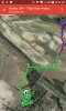
I really don't know when it lost connection. I only noticed it after I have been trying to get it to RTH and it wouldn't. The mavic ended up trying to land in a tobacco field way down the road. A friend ended up going down the road and finding it hovering above the tobacco trying to land.

Here is the link to that scary flight.

Airdata UAV - Flight Data Analysis for Drones

I haven't had an issue since that I knew of until I created my airdata account yesterday and uploaded all of my logs and I see this... The first link is of a flight that had good connection... the second link is of one that had very poor signal.. same day, time, and location.

Airdata UAV - Flight Data Analysis for Drones

Airdata UAV - Flight Data Analysis for Drones

What do y'all think the problem is?
 
I'm no expert in reading flight data, but according to the analysis you lost connection at 800+ feet. Is that correct?
 
Please upload your TXT flight log here and post a link back here. You'll find instructions for locating your TXT flight log at that link.
 
I'm no expert in reading flight data, but according to the analysis you lost connection at 800+ feet. Is that correct?


I did and I know that was bad. I had converted feet to meters wrong in my max altitude setting. I've fixed that now.

Did you look at the other two flights?
 
I did and I know that was bad. I had converted feet to meters wrong in my max altitude setting. I've fixed that now.

Did you look at the other two flights?
No worries...I'm not the "drone police". Anxious to see what @msinger finds
 
Here's the flight path your Mavic should have followed when it was returning to the home point (the yellow line):

Path.jpg


Since your Mavic was not following that path and it was only returning at about 3 MPH, I'm assuming the wind was just too strong for it to return home. It probably continued returning on the path as best as it could and eventually auto landed when the battery reached the critically low level.

The missing pieces of your flight log will be available in the DAT flight log. You can retrieve that log like this and view it in DatCon. If you need help reviewing it, please upload it to dropbox.com and post a download link back here.
 
Here's the flight path your Mavic should have followed when it was returning to the home point (the yellow line):

View attachment 16286


Since your Mavic was not following that path and it was only returning at about 3 MPH, I'm assuming the wind was just too strong for it to return home. It probably continued returning on the path as best as it could and eventually auto landed when the battery reached the critically low level.

The missing pieces of your flight log will be available in the DAT flight log. You can retrieve that log like this and view it in DatCon. If you need help reviewing it, please upload it to dropbox.com and post a download link back here.


Thanks for taking the time to review this.

The Mavic wasn't found where it shows on the map.. See attached picture of where it was found(in the red squiggly area)

Does the very poor signal come into play?
 

Attachments

  • IMG-20170702-WA0000.jpg
    IMG-20170702-WA0000.jpg
    158.2 KB · Views: 20
Anyone have any idea on why I'm getting very poor signal reporting that I posted in my first post?

Same location, same timeframe but got excellent signal one time, very poor signal on the signal map another time.
 
Lycus Tech Mavic Air 3 Case

DJI Drone Deals

New Threads

Forum statistics

Threads
131,139
Messages
1,560,282
Members
160,109
Latest member
brokerman