DJI Mavic, Air and Mini Drones
Friendly, Helpful & Knowledgeable Community
Join Us Now

Lost mini in wind - 100% my fault!!

Buel

Well-Known Member
Joined
Apr 16, 2020
Messages
139
Reactions
38
Age
47
Location
Wales
Hi all,

Last Sunday I used my drone to take a lovely pic of my daughters and I outside our house. It was very windy that day but, stupid old me, decided to gain some altitude and try to take a better pic. Long story cut short, I lost signal and never regained it.
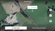
I have attached below a screenshot of my phone showing the last recorded location. I walked there and gave it a **** good search but couldn't see it. I was hoping for some help on here but have just seen a similar thread where someone got the data of the flight? Please can I have a hand finding that?

Because I'm a newbie, I turned the handset off and back on hoping to 're-establish' connection when I arrived at the site but couldn't pick it up and was asking me to do the start up of turning the drone around 360 degrees, etc.
Oh and I see my RTH was set at 15m.

Please can I ask for some help here (even if I don't deserve it).
I guess my questions are:
1. How do I get the relevant data?
2. Was turning the handset off a big mistake?

(sorry for this)
 

Attachments

  • thumbnail_IMG_0057.png
    thumbnail_IMG_0057.png
    5 MB · Views: 88
1. How do I get the relevant data?
To get the flight data ..
Go to DJI Flight Log Viewer | Phantom Help
Follow the instructions there to upload your flight record from your phone or tablet.
That will give you a detailed report on the flight data.
Come back and post a link to the report it provides.
Or just post the .txt file here.

>>>2. Was turning the handset off a big mistake?
Turning off the controller would only force RTH (if it hadn't already been initiated).
So that shouldn't have been a problem

You mentioned that when you turned the controller on, you had a message asking to recalibrate the compass.
That is very unusual and wouldn't be expected if the drone was in flight.
It suggests that the drone had landed and was very close to a steel item.
 
  • Like
Reactions: NG Wildman
****, can only view them as CSV?
 

Attachments

  • DJIFlightRecord_2020-11-01_[10-28-16].txt
    2.8 MB · Views: 15
  • DJIFlightRecord_2020-11-01_[10-28-16].txt
    2.8 MB · Views: 4
  • DJIFlightRecord_2020-11-01_[10-28-16]csv.zip
    168.1 KB · Views: 5
That Home point is not where I was? That's about 500 yards from my home? (The map is old and doesn't show the housing estate I live on)
 
I let these guys that know their data figure it out, but are not those trees higher than 45 foot/ 15 Meters? I hope you find it, but remember to set RTH height over the tallest item in your flying area when/if you get her back.
 
I let these guys that know their data figure it out, but are not those trees higher than 45 foot/ 15 Meters? I hope you find it, but remember to set RTH height over the tallest item in your flying area when/if you get her back.
You are 100% correct. Best go in to that wood now and take a look.....
 
That Home point is not where I was? That's about 500 yards from my home? (The map is old and doesn't show the housing estate I live on)
Your data looks like this: DJI Flight Log Viewer - PhantomHelp.com

It appears that you were somewhat disoriented and confused during the flight.
You were impatient and launched without waiting for GPS.
It wasn't until 0:37.5 that it was able to record a home point.
This is why the home point is not where you launched from.

Your RTH height was set much too high at 193 metres and the drone climbed to the RTH height where it was exposed to a high wind.
As it climbed, it was trying to hold position but pitch and roll data shows that the drone had to fight to maintain position.
Above 80 metres, it was unable to hold position and began to be blown toward the northeast at 2.5-4 metres/sec.

You started to bring the drone lower after it reached 193 metres and got it to 183 metres when the data stops at 12:07.5, presumably because you switched off the controller (?).
You had full signal and full control up to that point except for 50 seconds after 11:09.9 when you lost the downlink for 50 seconds.

After losing signal, the drone would have continued trying to get back to the false homepoint, but because the gusty winds at height were too strong for the Mini, it will have continued blowing toward the NE at 2.5-4 m/s until the battery reached critical low voltage, when it will have autolanded.

The wind appears to have been variable in direction as well as speed, which makes it difficult to calculate a likely search area.
Burning the battery at 12.6 seconds per percent, it would have continued blowing away for approx 8 more minutes before autolanding.
A rough estimate puts it approximately 1.2 - 1.9 kilometres further to the northeast.
 
  • Like
Reactions: EyesWideShut
This shows a rough idea of where the drone may have ended up, somewhere one side or the other of the yellow line.
It looks like a needle/haystack scenario.
i-Jqht8h9-L.jpg
 
Thank you so much for the help. I feel suitably told off and ashamed.

Wouldn't the RTH being set at 15m make a difference?
 
Last edited:
Wouldn't the RTH being set at 15m make a difference?
RTH was not set at 15 metres at all.
It was much too high at 193 metres.
Open the link I posted in #11 to see the drone climbing all the way up to RTH height near the end of the data.

But if it was at 15 metres, the drone should have had no problem getting home
... although it would have been the false homepoint rather than where you launched from.

If the RTH height had been set at 15 metres, the drone would have come home at 29 metres higher than the launch point as it was at that height that RTH was initiated.
If there were any obstacles higher on the return path could have caused a problem.
 
Last edited:
Thank you so much for the help. I feel suitably told off and ashamed.

Wouldn't the RTH being set at 15m make a difference?
Maybe a 3D picture of what happened is easier for you to grip ... as soon as the failsafe RTH kicked in, your Mini started to ascend up to the set height shown here below. It's clearly visible on which height it started to drift down wind. Unfortunately it's to no use trying to calculate any touch down location ... the possible area will be to large to give us any kind of accuracy.

1604767455660.png

1604767193379.png
 
  • Like
Reactions: CarlsbadAL
GOSH this forum is great!!! Thank you!! I mean that. Yes I've been a d**k but I'm OK with that, I will learn from it, but I want to say how much I appreciate the help.
 
Another question I would like to ask, as a newbie, is why I am able to view all the 'stored' videos? I thought I had lost them forever with the mem card (although I did back most of them up) but it seems there is a 'memory', so to speak?
 
Another question I would like to ask, as a newbie, is why I am able to view all the 'stored' videos? I thought I had lost them forever with the mem card (although I did back most of them up) but it seems there is a 'memory', so to speak?
You have the answer in this YT clip...

 
Wonderful, thanks.
Question on cache files - I have now chosen 16gb (as I will definitely be buying another mini next week) but what is auto?
Edit - just found it out.
 
Last edited:
Hope you find your drone. As a suggestion, go to Mavic Help and Mavic Tips, 75 tips on how to prevent flyaways. Knowledge is power, things still do happen, but less often.
 
  • Like
Reactions: Buel
Lycus Tech Mavic Air 3 Case

DJI Drone Deals

New Threads

Forum statistics

Threads
131,002
Messages
1,558,768
Members
159,985
Latest member
kclarke2929