DJI Mavic, Air and Mini Drones
Friendly, Helpful & Knowledgeable Community
Join Us Now

Mapping flight in Naples, FL? Nope, Mosquito Control!

Zbip57

Well-Known Member
Joined
Apr 25, 2020
Messages
1,170
Reactions
1,259
Location
Canada
We're visiting with my mother-in-law in Naples Florida. During the day there is steady aircraft traffic crossing overhead at about 1000' heading into and out of Naples airport, lots of small executive jets and propeller planes. But it's normally dead quiet at night. Until last night...

Holeeeey! At about 9:30pm a very loud propeller driven plane roared past at an alarmingly low altitude. What was THAT? That's certainly not normal.

A few minutes later it came back again, at the same crazy low altitude, heading in the opposite direction, and then again coming back the other way!

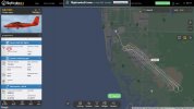
So I fired up FlightRadar24, and there it was. They were obviously running some sort of mapping operation running parallel tracks about 1000' apart, but at night, and at VERY low altitude, continuing for almost an hour. What's up with that?
WhyAt930pm.jpg

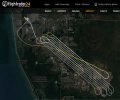
I pulled up the full flight track this morning, and see they mapped another area the previous night running from 9pm to 11pm.

Anybody know what that's all about? I guess they need to do it at night when there's not the usual other air traffic filling the skies around here. But it sure freaked us out when that thing went thundering back and forth seemingly at rooftop height at night. If they're planning to map the entire city, they'll be at it for several more nights.
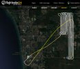
Dec7_9-10pm.jpg

Dec6_9-11pm.jpg
 
The flights are methodically covering these parts of the city. But they can't be photographing anything in the dark at night, can they?

So what are they doing?
 
3D laser scanning? But this is usually done at heights over 100 m, at least here. And a helicopter was used, not aeroplane.

How do I know this? Due to safety reasons (powerful laser) an agency required (and I had to design ...) a device for such aeroplane, which measures distance to the ground bellow the laser and warn the pilot, if height is lower than 150 m and additionally disable laser output if height is bellow 100 m.

Regards,
G
 
After some more research, I now think it might be mosquito control.

Here's a news article and video from earlier in May this year. I had to laugh when the reporter said they're spraying "incesticide". 😆 Yup, gotta keep that under control for sure.

The news article says they fly those patterns at 50' height, which is exactly what the FlightRadar24 data showed in the first image posted above.

www.winknews.com/2022/05/23/low-flying-plane-captures-attention-of-lehigh-acres-neighborhood/
 
If it really was a DC-3 no wonder it sounded loud flying low. Those weren't exactly stealth planes.
 
If it really was a DC-3 ...
I'm pretty sure it was something slightly smaller than a DC-3. FlightRadar24 shows it as a De Haviland Canada DHC-6-200 Twin Otter. That's what it sounded like. Definitely twin engine, and definitely flying frighteningly low.
 
Aha, it's confirmed. Mystery solved. It was mosquito control.

The DC-3 shown in the news article linked above belongs to the Lee County Mosquito Control, which is just a bit further north from us covering Fort Myers and Cape Coral.

Here in Naples and Lely, we're in Collier County and that's covered by the Collier District Mosquito Control. This is a screen shot of their map showing their most recent flight coverage.

CollierDistictMosquitoControl.jpg
 
  • Like
Reactions: AlanL
I was only down here for a few days getting my mother-in-law set up before heading back to the snows of winter up in Canada. I'm not used to seeing these low level mosquito control flights. It scared the bejeesus outta me!

Attempting to make this thread at all relevant to the Mavic forum, imagine you're conducting an evening drone flight under what you consider to be safe conditions when this big plane suddenly comes scorching past barely at treetop height. It really had me startled.

In the many times I've been down here, I've never seen a plane come by this low. But apparently it's quite common. Nobody else seemed the least concerned. I've not even ever noticed any mosquitoes down here. But I guess it's the ideal environment for them, what with all the swamp lands and the many ponds and water traps surrounding the golf courses everywhere.

It must be a big business if Lee County and Collier County can each afford their own fleet of expensive helicopters and planes dedicated to eradicating mosquitoes. Back home we simply task the squadrons of dragon flies and bats to deal with that issue. Cold temperatures are also very effective at keeping our mosquito population under control during winter.

Heading home...

Warp9.jpg
 
They may want to consider a DJI Agra. So much cheaper to operate. And much quieter, too! I can think of many more advantages, but I made my point.
 
  • Like
Reactions: MAvic_South_Oz
It's quite interesting. I've been reading up some more on their websites and they use many different methods depending on the scale of the operation. At the smallest backyard scale they just use handheld sprayers, or UAS for larger areas which are not yet large enough or too sensitive for full-sized aircraft. Their most often used manned aircraft are helicopters, but fixed wing aircraft are required whenever covering vast areas.

Unmanned Aerial Systems - Lee County Mosquito Control
 
Yup - lots of mosquito control planes in FL. And they do fly low!!!
 
I have lived in Florida a long time, A lot of coastal counties and some inland counties do late evening mosquito control when the counts get high enough or certain species are trapped. We are thankful for it.
 
From my tourist knowledge of the area the flights were not over any sort of human population. Did I miss it in the correspondence but did you apply for LAANC at all or perhaps you never took off? The flights will have stirred up the local turkey and black vultures!
 
Without air conditioning and mosquito control, no one would live in Florida. Well, maybe a few brave souls, but not many.
 
From my tourist knowledge of the area the flights were not over any sort of human population.
Go to FlightRadar24.com and type "N647MC" in the search bar to bring up the flight records of the De Havilland Twin Otter which was doing the flights. Then scroll down and find the Dec 6th and Dec 7th flights and click "Play".

That brings up the maps I showed in the first post in this thread. Except on their map page you can zoom in much closer. In the top right corner of the map there's a button to change settings where you can switch from the default Map mode to Satellite or Hybrid. That way you can see how built-up the areas actually are.

Did I miss it in the correspondence but did you apply for LAANC at all or perhaps you never took off?

I used to enjoy bringing a camera drone with me everywhere when on vacation, but I've given up trying to make any sense of the FAA's ever-increasingly-complex, divergent, and bizarre regulatory requirements in the USA. It's just not worth it anymore.

So, no, I did not fly any of my drones during this visit. But here's one from seven years ago using my old Phantom-0.

 
Go to FlightRadar24.com and type "N647MC" in the search bar to bring up the flight records of the De Havilland Twin Otter which was doing the flights. Then scroll down and find the Dec 6th and Dec 7th flights and click "Play".

That brings up the maps I showed in the first post in this thread. Except on their map page you can zoom in much closer. In the top right corner of the map there's a button to change settings where you can switch from the default Map mode to Satellite or Hybrid. That way you can see how built-up the areas actually are.


I used to enjoy bringing a camera drone with me everywhere when on vacation, but I've given up trying to make any sense of the FAA's ever-increasingly-complex, divergent, and bizarre regulatory requirements in the USA. It's just not worth it anymore.

So, no, I did not fly any of my drones during this visit. But here's one from seven years ago using my old Phantom-0.

Know how you feel. We’ve been going to Naples for 15 years and never seen those horses. I go birding with my old mate Jerry Jackson at Eagle Lakes every year and have flown my Spark there (well away from the Lakes and birds). Will go and have a look but perhaps they are on a private estate?
 
We’ve been going to Naples for 15 years and never seen those horses.

The horses sculpture is located here, at the entrance to Lely Resort. There is a small parking lot right behind the sculptures, so you can get out and walk around.

There is a similar but smaller sculpture at the other entrance with only three horses here. It doesn't show on the satellite view but can be seen using Streetview.
Thanks. Will check them out when we get over next time.
 
They may want to consider a DJI Agra. So much cheaper to operate. And much quieter, too! I can think of many more advantages, but I made my point.

Many local councils (local GOVCO / local cities) here in Australia are using them now, but only for relatively small wetlands areas near suburbs, for where / when mossie populations might start to get out of control.
I can see the sort of areas covered in the original post require the aircraft spraying.
When the Agras style drones can dock, recharge, and refill automatically through a night though, it could cover decent areas at very low altitudes, with far less intrusive flight characteristics.
 

DJI Drone Deals

New Threads

Forum statistics

Threads
131,141
Messages
1,560,320
Members
160,112
Latest member
lucian