


You are using an out of date browser. It may not display this or other websites correctly.
You should upgrade or use an alternative browser.
You should upgrade or use an alternative browser.
Mavic 2 Lost to the Ages
- Thread starter Bryce steiner
- Start date

Cymruflyer
Well-Known Member
Looking back what I believe I should have done was take a picture straight down, kill the motors right then and just let it fall. Then it should have been right at the coordinates.
Looking back, it would probably be better to have not broken the law or regs. by flying out of line of site. Then, you would possibly not have lost your drone and not be in mourning right now. It might have fallen out of the sky and hit a child in the head. I don't want to be the drone police but flying miles away is not a very clever thing to do, as a responsible drone pilot. Sorry for the loss though, but you made the choice and now have to deal with the consequences. I hope you will be able to find it.
macfawlty
Well-Known Member
We all got enough scolding growing up. If we all waited for conditions to be absolutely perfect, in a world with no wind, no obstacles and no risk, our birds would be gathering dust. Everywhere and every time I fly, there are a variety of issues with the location and the conditions. I fly in areas and locations worthy of the flight. Flying in a big open field somewhere on a perfect day would bore me to sleep and, while dozing, with any luck my bird would RTFH and land at my feet. I'd hate to lose mine, but I got insurance for a reason. Unlike a labrador or retriever, I'm not emotionally attached. My biggest concern is losing great footage.
Seriously though, don't fly too far. Respect the wind, altitude, low battery warnings and flight path. And get insurance.
Seriously though, don't fly too far. Respect the wind, altitude, low battery warnings and flight path. And get insurance.
F
FormerMember07122019_2
Guest
It's not my software - I was referring to the kind of data analysis software that is necessary to manipulate and analyze the data. These programs (MATLAB, Mathematica, Igor Pro etc.) are not cheap and require a reasonable familiarity with mathematics to use them.
I was guessing that you used something like MATLAB. I used it a few decades ago and it does have a fairly steep learning curve and can cost more than a Mavic 2. Very powerful program used by mathematicians, physicists, and engineers, etc.
paulatkin73
Well-Known Member
Yes - that's the correct file. I have no idea what you were trying to do though. This aircraft was not making it home even without the problems it encountered - you flew it too far downwind. In terms of the event, at 812.5 s it lost connection for 35 s. Failsafe was set to "hover", and it was above the RTH height, and so it simply rotated to face the home point (south) and stopped. Unfortunately it looks as if that yaw maneuver generated disagreement between the IMU and the compass, and it ended up with an unrecorded yaw error. That led to uncontrolled flight to the southeast.
great analysis... more stories like that i read - more respect i get to the ardupilot software. I would not even imagine that model can do a flyaway after such attitude error. by any common sense logic it would had to do an immediate landing, not just keep trotting away in the unknown direction... so odd.
so, you think it is an IMU failure, or a compass got knocked over by the proximity of the power line? i am just getting very curious about that - how common are those IMU failures on those mavic 2s?
It looks like a compass error that manifested itself when the aircraft turned to face home. That could have been due to magnetic interference at the takeoff location, but it would require the mobile device DAT file to confirm - has the magnetometer and rate gyro data recorded separately.
F
FormerMember07122019_2
Guest
I may be stating the obvious but the OP said he flew near a couple of rows of high tension power lines prior to losing control. There can be a fairly high level of electromagnetic radiation emanating from them that may affect the compass. Especially if they are of the long haul variety.
I may be stating the obvious but the OP said he flew near a couple of rows of high tension power lines prior to losing control. There can be a fairly high level of electromagnetic radiation emanating from them that may affect the compass. Especially if they are of the long haul variety.
The aircraft was around 375 ft AGL and there were no significant power lines - just the low-level ones along the road. Additionally, EM radiation of that kind won't noticeably affect the compass.
That is not correct. There are ones alongside the road, but there are dual high tension lines running in parallel across that field your trajectory even showed. The drone is right close to the lines which are between me and the drone:The aircraft was around 375 ft AGL and there were no significant power lines - just the low-level ones along the road. Additionally, EM radiation of that kind won't noticeably affect the compass.

That is not correct. There are ones alongside the road, but there are dual high tension lines running in parallel across that field your trajectory even showed. The drone is right close to the lines which are between me and the drone:View attachment 65890
Those are still low compared to the aircraft, and south of the aircraft location. They were not responsible.
The good news is that with the trajectory by
Sar104 and
DJI Flight Log Viewer | Phantom Help
I was able to find it about est 200 feet directly east of the last point.
I'll post more in a little bit.
Is there anything that I can get in the drone that may give you more info?
Thanks!
Sar104 and
DJI Flight Log Viewer | Phantom Help
I was able to find it about est 200 feet directly east of the last point.
I'll post more in a little bit.
Is there anything that I can get in the drone that may give you more info?
Thanks!
The good news is that with the trajectory by
Sar104 and
DJI Flight Log Viewer | Phantom Help
I was able to find it about est 200 feet directly east of the last point.
I'll post more in a little bit.
Is there anything that I can get in the drone that may give you more info?
Thanks!
That was the more likely outcome. Unfortunately the onboard DAT file that likely contains useful information is not readable from the Mavic 2. DJI hid the encryption key.
ryanbruce
New Member
Holy crap, big congrats!The good news is that with the trajectory by
Sar104 and
DJI Flight Log Viewer | Phantom Help
I was able to find it about est 200 feet directly east of the last point.
I'll post more in a little bit.
Is there anything that I can get in the drone that may give you more info?
Thanks!
...and what did we learn?
")
The key will come... Just a matter of when.That was the more likely outcome. Unfortunately the onboard DAT file that likely contains useful information is not readable from the Mavic 2. DJI hid the encryption key.
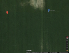

You can see here where it was on my iphone. I was using a iPad Mini last night and it's GPS location wasn't near as accurate as the iphone. I still don't think I would have found it last night though because I wasn't looking. Each corn row is 30" apart.
I walked and walked along a narrow trajectory and didn't find it I then moved more east and north. The stalks of corn do not make easier to find legs of drones! I found the battery first and it seems fine. About 12-15' and 2 rows over I found the drone. Scattered around the area I found the motor end of the leg and a broken prop.

Last point of contact in the log:
41.28449734,-84.76268577
Here is where it was found:
41.2845515, -84.7616649
By these numbers on the map it looks like they are about 270' apart.
I sure appreciate the help on this! It makes it much easier to send back to DJI now!
Attachments


You can see here where it was on my iphone. I was using a iPad Mini last night and it's GPS location wasn't near as accurate as the iphone. I still don't think I would have found it last night though because I wasn't looking. Each corn row is 30" apart.
I walked and walked along a narrow trajectory and didn't find it I then moved more east and north. The stalks of corn do not make easier to find legs of drones! I found the battery first and it seems fine. About 12-15' and 2 rows over I found the drone. Scattered around the area I found the motor end of the leg and a broken prop.
Last point of contact in the log:
41.28449734,-84.76268577
Here is where it was found:
41.2845515, -84.7616649
By these numbers on the map it looks like they are about 270' apart.
I sure appreciate the help on this! It makes it much easier to send back to DJI now!
I've seen a couple of cases like this now, where navigational errors appear to result in the FC shutting down or rebooting.
SAR 104 is my idol...
Misguided. Very misguided.
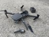
The silver ones came with it and two of them cracked fairly quickly. So I bought some new ones and that's what I got. They seem to work fine. Should they all be replaced in full sets?correct me if I am wrong... am I seeing Gold tipped props at the rear and silver tipped props at the front on that pic? mixing props?View attachment 65902
Similar threads
- Replies
- 28
- Views
- 4K
- Replies
- 1
- Views
- 822
- Replies
- 132
- Views
- 7K
- Replies
- 122
- Views
- 5K
- Replies
- 6
- Views
- 885


DJI Drone Deals
New Threads
-

-

-

-
-
 How To Find The Best Spots and Places To Fly Your Drone?
- Started by jaystechvault
- Replies: 1
Forum statistics
