DJI Mavic, Air and Mini Drones
Friendly, Helpful & Knowledgeable Community
Join Us Now

Mavic 3 Pro Suicide Slammed itself into rocks

If the drone was flown full speed backwards into the rocks, why is the front left arm on drone broken and not the back landing arms?
I'm betting the initial impact did not cause that damage. The OP likely has more details on what happened after that point.
 
  • Like
Reactions: RodPad
No


This is what your flight log shows instead:
  • You initiated auto takeoff and the drone climbed to 3.6 feet above the ground (large rock)
  • You manually ascended a bit more to 15 feet above the ground
  • You flew the drone at full throttle backward into the large rocks behind where you were sitting
View attachment 168346

View attachment 168347

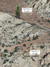
I suspect different. The take off point for the first flight and last flight was different.

The last take off point was in a flat land (at least according to Google Earth). Although that doesnt rule out it was crashed into rocks.

1695108993998.png
 
I suspect different. The take off point for the first flight and last flight was different.
Msinger's assessment of the flight data in post #18 is correct.
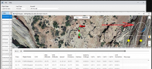
After climbing to 15 ft, at 5.3 sec, the OP pulled the right stick fully back until 7.5 sec, causing the drone to fly backwards (in a northerly direction), accelerating to 6.8 metres/sec.
The right stick was released at 7.5 sec and the left stick was pushed forward to lift the drone a little and rotate it slightly anti-clockwise, before the crash impact at 7.9 seconds.
 
Last edited:
No
This is what your flight log shows instead:
  • You initiated auto takeoff and the drone climbed to 3.6 feet above the ground (large rock)
  • You manually ascended a bit more to 15 feet above the ground
  • You flew the drone at full throttle backward into the large rocks behind where you were sitting
Are you saying the everything after around 7.8 seconds is the 'crash' progressing?
 
  • Like
Reactions: RodPad
Msinger's assessment of the flight data in post #18 is correct.
After climbing to 15 ft, at 5.3 sec, the OP pulled the right stick fully back until 7.5 sec, causing the drone to fly backwards (in a northerly direction), accelerating to 6.8 metres/sec.
The right stick was released at 7.5 sec and the left stick was pushed forward to lift the drone a little and rotate it slightly anti-clockwise, before the crash impact at 7.9 seconds.


In my unexperienced-eye, the "impact" pattern of this flight was somewhat atypical. The drone "path" turned ard 90 degree after impact (instead of bump back or immediate fall). and the change of speed was more graduate.

May I humbly ask, if there is any definate pattern/ key signature in the log to reflect an impact?
 
In my unexperienced-eye, the "impact" pattern of this flight was somewhat atypical. The drone "path" turned ard 90 degree after impact (instead of bump back or immediate fall). and the change of speed was more graduate.
Drones don't always crash at right angles to a flat vertical surface.
There is no such thing as a "typical" impact pattern.

May I humbly ask, if there is any definate pattern/ key signature in the log to reflect an impact?
Here it is highlighted in purple:
i-C3B7zgc.jpg
 
Are you saying the everything after around 7.8 seconds is the 'crash' progressing?
Yep, that's right about the point where things started heading south:

1695254825826.png
 
Man I just wanted to say that you guys are awesome. I almost lost my M3 OG a month ago. Meta was able to identify what i did wrong and how i could potentially avoid it in the future. I was lucky it was not a total lost. Thanks to you guys we appreciate you for taking time off your schedules to assist.
 
It's possible that everyone on this thread already knows this, but I discovered something to help clue me in to when the drone has GPS data and is ready to be flown.
I had typically waited until the icon for the number of satellites turned white, and this was accompanied by the message, both popup box and voice, stating that "the home point has been updated."
However, I got confused as at times, though the icon for number of satellites was white, and showed a high number of them (eg, 23 or more), I did not hear the message "the home point has been updated."

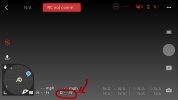
I then realized that when the GPS coordinates have been established, one will see that there is a number for distance (adjacent to letter D) on lower left of the controller screen. If there are no GPS coordinates there will not be a number in that spot yet, but once the GPS coordinates are obtained a distance number will display.
 
It when the GPS coordinates have been established, one will see that there is a number for distance (adjacent to letter D) on lower left of the controller screen. If there are no GPS coordinates there will not be a number in that spot yet, but once the GPS coordinates are obtained a distance number will display.
Can you post a screen capture of that please?
 
  • Like
Reactions: RodPad and Hermey
Can you post a screen capture of that please?
This shows where the distance number would go. In the area on lower left circled in red. Once the GPS coordinates are locked in, this changes from an empty field with dashes, to a number. If you step away from the drone a bit with the controller, the number should increase.
 

Attachments

  • DJI Fly screen ph.png
    DJI Fly screen ph.png
    129.9 KB · Views: 32
I then realized that when the GPS coordinates have been established, one will see that there is a number for distance (adjacent to letter D) on lower left of the controller screen. If there are no GPS coordinates there will not be a number in that spot yet, but once the GPS coordinates are obtained a distance number will display.
But ... you can have approximate (and inaccurate) GPS location data when the drone has only a few satellites.
Just wait until the satellite icon turns white which is the drone telling you that it has good location data, not just approximate data.
i-dVMfxb7-S.jpg


btw .. although the drone in this thread was flown without good GPS, the crash was completely unrelated to GPS issues.
 
I looks like there were problems with GPS on every flight, especially when you are nearest the canyon wall. There were indications you were having gimbal issues as well, even in the earlier flights. This canyon is over 500 feet deep, according to Google Earth. After the 5th flight you moved to an area where the canyon was even narrower, but about the same depth. No GPS and weak AGPS, yet you kept flying despite all of the warnings. Why? You moved from a bad spot to a worse spot as far as GPS was concerned. If I were on the freeway and the "check engine" light came on in my car, smoke was coming out of my tailpipe and steam from under my hood, I'm not going to look on the map for a hill to climb. I'm going to pull over and try to determine what the issue is. You have to pay attention to the warnings your drone is sending you and ACT upon them. You stated that you had only had the drone for 2 1/2 weeks and only flown it a handful of times. I have 3 DJI drones and an Autel, and I know each one of them intimately. I know their strengths and their weaknesses, and which one would be the best for any particular task. I have a big wide-open area I use to become familiar with any drone I haven't flown before. I fly it there and similar locations until I am absolutely comfortable with it. I would never fly any of my drones in a GPS deprived area under any conditions if I were getting multiple warnings that my drone was unstable and all resources were not available. I don't mean to sound rough, but drones have warning systems for a reason, and if you ignore the warnings you suffer the consequences.
 
I looks like there were problems with GPS on every flight, especially when you are nearest the canyon wall. There were indications you were having gimbal issues as well, even in the earlier flights. This canyon is over 500 feet deep, according to Google Earth. After the 5th flight you moved to an area where the canyon was even narrower, but about the same depth. No GPS and weak AGPS, yet you kept flying despite all of the warnings. Why? You moved from a bad spot to a worse spot as far as GPS was concerned. If I were on the freeway and the "check engine" light came on in my car, smoke was coming out of my tailpipe and steam from under my hood, I'm not going to look on the map for a hill to climb. I'm going to pull over and try to determine what the issue is. You have to pay attention to the warnings your drone is sending you and ACT upon them. You stated that you had only had the drone for 2 1/2 weeks and only flown it a handful of times. I have 3 DJI drones and an Autel, and I know each one of them intimately. I know their strengths and their weaknesses, and which one would be the best for any particular task. I have a big wide-open area I use to become familiar with any drone I haven't flown before. I fly it there and similar locations until I am absolutely comfortable with it. I would never fly any of my drones in a GPS deprived area under any conditions if I were getting multiple warnings that my drone was unstable and all resources were not available. I don't mean to sound rough, but drones have warning systems for a reason, and if you ignore the warnings you suffer the consequences.
The poor GPS reception had nothing at all to do with the crash.
It was 100% due to the drone being inadvertently flown directly into a rock.
 
The poor GPS reception had nothing at all to do with the crash.
It was 100% due to the drone being inadvertently flown directly into a rock.
I disagree. You shouldn't fly under those conditions. Especially if you don't know what you're doing.
The poor GPS reception had nothing at all to do with the crash.
It was 100% due to the drone being inadvertently flown directly into a rock.
So you don't think GPS is important to a safe and stable flight? REALLY? I've been doing it wrong all along then. Four years of experience down the drain. Sorry, but I disagree with you. The canyon was causing issues with the GPS and extreme caution should have been exercised.I don't ignore these kind of issues. I would have found a place at the top of the canyon and got the best shots I was able to and been satisfied with that. Of course, what do I know. You are the expert!
 
Lycus Tech Mavic Air 3 Case

DJI Drone Deals

New Threads

Forum statistics

Threads
131,132
Messages
1,560,144
Members
160,104
Latest member
Roger-N