DJI Mavic, Air and Mini Drones
Friendly, Helpful & Knowledgeable Community
Join Us Now

Max height increased to 1000m

Droning on and on...

Well-Known Member
Joined
Feb 11, 2018
Messages
4,198
Reactions
3,630
Location
Santa Cruz, CA
Wow, this is a big change!! Mentioned in this article: Max height setting increased in DJI Fly from 500m (1640ft) to 1000m (3280ft).

The article was about the M3 series and addition of waypoints. This little nugget was in there.

Can anyone verify? Also, anyone have any Intel on if this will expand to other models?

I'm glad the cynic in me was wrong about waypoints on the M3, now I'm going to get one. However, I'm still a cynical pessimist, and don't think we'll see waypoint support on another consumer class drone again.

DJI dug too deep a hole by committing to supporting waypoints on the M3, and decided they needed to fulfill that promise on the flagship M3. IMO that's the only reason, and this will be the last time.
 
Last edited:
500m has been the ceiling as long as I've been a DJI customer, going back to the P3.
 
Last edited:
The issue for most people is the 1000m is only outside the new 500m altitude areas which is pretty much everywhere but out in the boonies. Look at the DJI Geo map and you can see anyone in a medium sized city will have to do some real driving off the main highway to find an area that allows the 1000m flight. Luckily here in Alaska....between Anchorage and Fairbanks it's all good! No doubt we have more flyable area than any other state. :). works for me and I'm looking forward to getting some footage of a few hill tops I could not visit previously. The limit will remain VLOS but against a snow covered mountain it's pretty interesting how far one can see a drone climbing up the side of a hill if you keep an eye on it going out.
 
Didn't know about that limitation. Thanks for the 411!

For me personally, it's a non-issue. I'm never over 400' in urban areas, rarely over 200. Just too dangerous when there are other aircraft around randomly at any time. This tends to make flying tedious because of the big increase in effort necessary to maintain situational awareness.

I'm delighted the ceiling has been increased to over 3000'... there are so many small mountains around here that I can now get to the top of that I've wanted to...
 
I saw a youtube video saying the latest update allowed a 1000M altitude above home point, not just 800M

been really interested in that so I've been searching. As akdrone said, it appears it is still a 500M maximum within a 50KM/30mile radius of a restricted airspace. In populated areas that would just about guarantee overlap of the 500M zones.

however, I'm able to flt in many remote areas of Oregon that won't have any airports within 70-100 miles, let alone 30 miles. And there are plenty of cliffs and steep mountains where a 3280 foot ceiling would open up lots of droning potential....so I'm excited about that

just have to see somebody verify that the 1000M limit works
 
500m in mine from what I remember
Everyone, 500/1000m is correct.

I didn't actually do the math. Was lazy and took someone else's figures that apparently is as lazy as I am 😆

I've corrected the thread title and my posts. Thanks
 
  • Like
Reactions: Yorkshire_Pud
Wow, this is a big change!! Mentioned in this article: Max height setting increased in DJI Fly from 500m (1640ft) to 1000m (3280ft).

The article was about the M3 series and addition of waypoints. This little nugget was in there.

Can anyone verify? Also, anyone have any Intel on if this will expand to other models?

I'm glad the cynic in me was wrong about waypoints on the M3, now I'm going to get one. However, I'm still a cynical pessimist, and don't think we'll see waypoint support on another consumer class drone again.

DJI dug too deep a hole by committing to supporting waypoints on the M3, and decided they needed to fulfill that promise on the flagship M3. IMO that's the only reason, and this will be the last time.
Very interested in your report. I live in mountainous country in Australia, and frequently fly at 500m…….have not been able to go beyond. Will go up this morning and see if anything has changed for me. Thanks for the heads up.
 
I'm waiting anxiously for somebody to confirm that 1000M ceiling
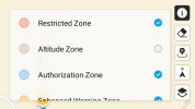
It already has been confirmed. However, it only exists in areas that are outside of a 50km radius from all airports, and not subject to any other restrictions, which means way out in the boonies! It is creating more problems than it is solving, though! It now adds an additional gray Altitude layer over the maps of 500m within 50km of all airports, preventing you from seeing the maps underneath!
 
400' is my guidance number.
I have no idea here y'all are thinking this is allowed...
Or has April fools arrived early?
 
It already has been confirmed. However, it only exists in areas that are outside of a 50km radius from all airports, and not subject to any other restrictions, which means way out in the boonies! It is creating more problems than it is solving, though! It now adds an additional gray Altitude layer over the maps of 500m within 50km of all airports, preventing you from seeing the maps underneath!
I'm curious how the drone/app determines if it's outside any 50KM radius. There is no cell signal in the 'boonies' I frequent, and if I don't pre-load area maps (I've tried but have been unsuccessful) showing airports, how it that radius determined?

maybe by GPS?
 
Last edited:
400' is my guidance number.
I have no idea here y'all are thinking this is allowed...
Or has April fools arrived early?

The embedded drone height limit is above takeoff point, so if you take off next to a steep mountain you can pretty easily cap out at 1640 feet while still being less than 400 feet AGL and still (barely) within VLOS. It happens to me once in a while since I live next to a mountain like that. Unfortunately, I also live within 50 km of an airport so it is unlikely I will be able to take advantage of the new limit.
 
400' is my guidance number.
I have no idea here y'all are thinking this is allowed...
Or has April fools arrived early?
is it really that difficult for you to analyze?

I'm out in the high desert. I'm preparing to fly my drone in a general direction. In that general direction, about 500 feet ahead, is a steep mountain slope that gains elevation rapidly. It goes up around 2100 feet above my home point, with a more gradual slope up to the summit about 2800 feet, again, above my home point.

with the older 1640 foot ceiling limit above home point, I'd have to turn around or fly parallel to the slope. And I couldn't video/photo much of the landscape above that elevation

however, with a 3280 foot ceiling limit, I could actually fly above the summit of the slope and see over the other side. And, importantly, I could do so while still flying within 400 feet of the land below.

in a lot of the areas I fly when I'm out camping/recreating, this higher ceiling would open up landscapes and video/photo opportunities unavailable now. I understand it wouldn't for most pilots, but it would for me, and I wouldn't be violating any rules
 
It already has been confirmed. However, it only exists in areas that are outside of a 50km radius from all airports, and not subject to any other restrictions, which means way out in the boonies! It is creating more problems than it is solving, though! It now adds an additional gray Altitude layer over the maps of 500m within 50km of all airports, preventing you from seeing the maps underneath!
You can deactivate this layer in map view. Just click on the i.

1.jpg
 
You can deactivate this layer in map view. Just click on the i.

View attachment 158664
That change has the unwanted effect of removing ALL Altitude Zones, including the ones you need to be aware of that are extensions of the flight lines around all the airports inside the 50km radius! This is just dumb implementation by DJI of a feature that 99% of pilots will never use, and can't legally use anywhere, unless they are mountain climbing in the boonies, over 50km from all airports!
 
That change has the unwanted effect of removing ALL Altitude Zones, including the ones you need to be aware of that are extensions of the flight lines around all the airports inside the 50km radius! This is just dumb implementation by DJI of a feature that 99% of pilots will never use, and can't legally use anywhere, unless they are mountain climbing in the boonies, over 50km from all airports!
I am also out in very remote areas frequently, plenty far away from the nearest airport, so this is nice to know👍
 
That change has the unwanted effect of removing ALL Altitude Zones, including the ones you need to be aware of that are extensions of the flight lines around all the airports inside the 50km radius! This is just dumb implementation by DJI of a feature that 99% of pilots will never use, and can't legally use anywhere, unless they are mountain climbing in the boonies, over 50km from all airports!
that is not at all what I am seeing. everything I used to see including altitude zones and permission zones are all there. The only change I see is the large 1000 meter zones that are visible when I use Mavic 3 in the DJI Geo Zone web site.
 
  • Like
Reactions: tls3601
that is not at all what I am seeing. everything I used to see including altitude zones and permission zones are all there. The only change I see is the large 1000 meter zones that are visible when I use Mavic 3 in the DJI Geo Zone web site.
Unless they have changed something from the original implementation, you have to turn off all Altitude layers to be able to view the map underneath the gray 500m altitude limit that exists everywhere else, within 50km of any airport. If you are within 50km of airports, there are also Altitude Zones coming off all the airport runways that you can no longer see when you need to turn off the Altitude layers to be able to see your otherwise obscured maps. What are you seeing that is different from that, in the areas within 50km of airports?
 

DJI Drone Deals

New Threads

Forum statistics

Threads
134,599
Messages
1,596,666
Members
163,099
Latest member
tabarton94
Want to Remove this Ad? Simply login or create a free account