DJI Mavic, Air and Mini Drones
Friendly, Helpful & Knowledgeable Community
Join Us Now

MPP disappeared in the mountains. Probably located after more than 2 years.

PeRo

Well-Known Member
Joined
Oct 11, 2018
Messages
72
Reactions
47
Age
61
Location
Bavaria, Germany
Now, the crucial issue would be to go there, pick up and return safely. Maybe you can help me getting additional confidence. Search description at the end of this text.


The story:

In March 21 my MPP disappeared from the sky due to a midair shutdown, caused by a combination of pilot error and a rapidly collapsing Battery cell (see link to thread below).

Final MPP Flight - Loss and Learning

The MPP was pre-owned with a 3rd Party Battery.

MPP_Battery.jpg


At the time of the accident, I had no idea what happened, but only was aware that the last GPS coordinates point to a fairly inaccessible area close to an adjacent rock cliff. At that stage the search attempt was aborted.

At home, the FlightLog analysis disclosed the details of the incident. Thanks to @msinger (CsvView) and @sar104 (deep insights into Flight Log Analysis and impact point determination), I calculated the crash site to at least additional 85m/250ft down the flight path (iteration, unfortunately no differential equation).

With the adapted coordinates, a first recovery attempt (spring 21) was started. However, the area seemed to be even worse in terms of accessibility. Difficult terrain with rock walls and slopes between 45° and 90° prevented any on site search. Frustratiing.

The only achievable result was a set of aerial shots of the flight path and crash site made by anothe AC. The images had to be taken from relatively high altitude of ~ 30-50m/90-150ft to avoid running into the surrounding tall trees and rock formations.

Looking at dozens of images, searching for a small pattern as an MPP – my confidence to find anything was nearly zero. If any of you ever tried to identify such an object on an aerial landscape image with trees, bushes and all other kind of vegetation...

Surprisingly, I found something. In fact, there were more somehow fitting objects, but apparently, several rocks and snow dots did also fit into the search pattern. This way, if you have checked enough images you start believing to have found plenty of Mavics – or nothing. For me that meant, that I put the results aside - until the next recovery attempt.

In Summer 21 my second recovery attempt took place. I wanted to explore a new route to the bottom of one of the rock faces, with potentialy better options to climb and reach the crash area. Failed again and was still away by about 100m/300ft.

Again some aerial shots were retrieved and with changed scenery due to the summer vegetation. Almost unbelievable, but when investigating the images, there was one shot (same spot and orientation) as the already mentioned one from Spring. And despite the bushes and the leaves, it revealed a place with the same suspicious blurry object.

That's the point where I am now – more than 1 1/2 years later. Probably located now but not quite sure because of the blurring when the photo is enlarged. Maybe there is some Bias in my search as well – if you want to find a certain object, you might start to recognize it everywhere.

Reliable and precise location is vital for my next attempt. Even a small horizontal difference of 5m/15 ft from the calculated impact spot might sum up to a vertical deviation of up to 50m/150ft, with respective consequences for the size of the search area. One simply can't go there and look around, you have to narrow down your target spot beforehand.

So, if you want to come to your own conclusion reg. its location, here are the images:
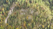
  • Crash area (Partial mountain view with location marker)
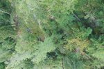
  • Crash site in Summer 2021
  • Crash site in Spring 2021
Mountain-View_s.jpg


Crash-site_Summer_s.jpg

Link to max. resolution:
b_Crash-site_Summer.JPG
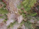

Crash-site_Spring_s.jpg

Link to max. resolution:
c_Crash-site_Spring.JPG


Please note:
  • The terrain, shown in the images, is not flat but rather steep (45° up to 90° angle).
  • There are various MPP shaped patterns (reflecting Rocks, Snow, Wood)
  • Lowest altitude AGL should be at least 30m-40m / 90ft-120ft AGL
  • Object: Mavic Pro Platinum (Silver) with dark grey Battery
Can you spot the MPP with confidence?

For those of you who don't want to waste their time turning the pixels upside down, and if there are no findings / replies in the meantime, I will post the same images but with position markers later on.

Anyway, I am now preparing for the 3. (and definitely last) recovery attempt. This time with a rope to get somehow down the cliff and close to the probable location. Btw., hanging below a Rock Face is not one of my favorite hobbies.

No need to say that there is no Business Case in it, as the MPP is now sitting for 2 winters in the harsh conditions of the Alps. Nevertheless, I would like to remove it from Nature...and I am curious about its condition.

Thanks!
 
While I might have seen something in one of the photos, it certainly wasn't definitive. That looks like an incredibly difficult place to get to! If you do end up going, let us know what happened.

I can appreciate what you are doing - I lost my first mini at a waterfall in the woods - it hit a tree branch, fell into the creek and disappeared. We looked for a couple hours, even using some underwater cameras on a second trip in case it got lodged somewhere under a log or something, but we never did find any traces of it. The forest burned the next year....
 
  • Like
Reactions: mereflyer and PeRo
I lost my Air 2 on an Extended flight capturing lightening in the sky and landed in the trees two years ago just 50 ft away from my house and I still cannot find it.
\
Its the one time I had the all Black Wet Suit which is impossible to spot in the trees . If i would have had any other color I am sure I would have spotted it , none the less every year I search the bushes and trees for it.. GPS was no help and even hearing the drone beep for an hour did not help me. This is where a nice Color like Rescue Red or Neon Blue Wet suit might have been a benefit.

Now that I Ordered the Mavic 3 Pro with its Zooms i will try again.

Phantomrain.org
Gear to fly in the Rain. Land on the Water
Well, you just shot your sales for the black wet suite. LOL.
 
I know i'm not there and don't see the real situation. It seems as though you could fly closer. I have flown between the trees to take some photos. With the image you have I don't see how you could even believe it's the drone.
The best of luck in your endeavors.
From searching dozens of images, it seems there is only a very small observation window where suitable orientation and camera angle allow spotting this Mavic shaped object. Otherwise, vegetation will prevent any direct view.
The issue with flying closer is that the AC then would have to approach trees. As my only accessible, reasonable safe place does not allow to keep VLOS and if "connection lost-RTH" would be triggered, it could easily end up in the branches.
 
  • Like
Reactions: mereflyer
While I might have seen something in one of the photos, it certainly wasn't definitive. That looks like an incredibly difficult place to get to! If you do end up going, let us know what happened.

I can appreciate what you are doing - I lost my first mini at a waterfall in the woods - it hit a tree branch, fell into the creek and disappeared. We looked for a couple hours, even using some underwater cameras on a second trip in case it got lodged somewhere under a log or something, but we never did find any traces of it. The forest burned the next year....
Yes, the place where the AC crashed to the ground could have been better...
Next weekend, I will post the images with my location markers. Then it will become easier to decide.
 
  • Like
Reactions: mereflyer
Don't give up. I lost my M2 Zoom last July - I flew into a tree backwards. It was up about 75 feet up and it sounded like a swarm of bees until I shut it down. Finding a gray drone in a tree with gray bark doesn't work. I searched the tree in the fall / winter after the leaves were gone and still could not see it. After a severe windstorm in January, I went back to look again and the branch it was on had broken and spotted the drone about 50 feet into some deep blackberry brambles. I came back with a machete and hacked a trail to the drone. Some of the props were damaged, but the drone seemed OK. After letting it dry it for a few days, I put in a fresh battery and everything worked except the obstacle avoidance. I sent it back to DJI (long out of warranty) and they repaired it.

Still flys great!
 
I can relate to your delima ,i have two lost drones in the mountains mine caused by a magenetic disturbance on top the second hill I then invested into a marco polo locator with out it i would not have found the third drone lost on the same route or missionand that was lost due to piliot error simply put I neglected to change the return home allitude any way the drone was 250 yrds off course and in a tree magnetic interferance caused a los of accurate gps coordinates en closing a photo of the drone in a tree , my air searches of more than 100 flights did not show a thing all i can tell you is unless you can get there and search you will be lucky to get a glimpse of it
20191226_160527~2.jpg
 
I can relate to your delima ,i have two lost drones in the mountains mine caused by a magenetic disturbance on top the second hill I then invested into a marco polo locator with out it i would not have found the third drone lost on the same route or missionand that was lost due to piliot error simply put I neglected to change the return home allitude any way the drone was 250 yrds off course and in a tree magnetic interferance caused a los of accurate gps coordinates en closing a photo of the drone in a tree , my air searches of more than 100 flights did not show a thing all i can tell you is unless you can get there and search you will be lucky to get a glimpse of it
View attachment 163333

Impressive mapping mission. And it shows how a colorful AC painting can save the day.
 
Side note:
The battery diagram (post #1) showed the thresholt voltage (SMART_BATTERY:voltage [V]) at which the MPP was cut off by the FC.
Approx 30 sec before the flight was terminated, battery cell 3 started to rapidly deplete and reached unhealthy 1,79 V, while the total resulting voltage went down to exactly 8,88.
Btw., 8 is the most important "Lucky Number" in Manufacturer's country... :)
 
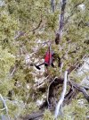
Here is where I think it might have "landed" (see yellow circles).
There seems to be only a very small observation window which allow to spot this somehow mavic shaped object. Only 2 of dozens of images display this specific location, as trees and bushes usually block the view to the surface.

Images:

Crash site (Summer 2021) with position marker
CS_Summer-21LM

Crash site (Spring 2021) with position marker
CS_Spring-21LM


What do you think?

This area is hard to reach, as it is half way down a steep 100m/300ft rock face, with some vegetation which seem to make it even more slippery and difficult to climb. A rope would be mandatory, therefore there will be not many options to explore a larger area in case of a "false positive".

My advice would be to go look if you look at the outing as more of an adventure and less of a "I want to find my drone". I kind of think finding it would be unlikely, but those spots do look pretty similar and do look like it could be a drone.

If you do go, be safe - that does look pretty crazy to get to. And if you do go, let us know what happens.
 
  • Like
Reactions: PeRo
Yes, you both are right, @TonyPHX and @rwilliam99.
It all started with some kind of forensic exercise, getting to know what caused the sudden disappearance of the MPP.
Inspired by well known members in the forum, which are able to precisely analyse flightlogs and narrow down the point of impact / landing to few m/ft, I was curious whether basic Maths and Physics can guide me to the missing Mavic.

The final step of performing the recovery attempt might not be the smartest move, but still interested to verify my results and experience the condition of the AC remains after such a freefall and staying out in the mountains that long time.

I have to say I completely understand where you are coming from. With the info you've been able to gather, it sounds like quite an interesting adventure to see if you can indeed find it, and if so, what does it look like. I'd probably opt to go and try and find it as well - but then again I like hiking cross country and/or on old abandoned trails.... :)
 
  • Like
Reactions: PeRo
Be sure to update us no matter how your rescue mission proceeds. It is an interesting story. Wish you well of course!!
 
  • Like
Reactions: PeRo
Here is where I think it might have "landed" (see yellow circles).
...
What do you think?
My eye was draw to exactly this without having seen your location markers. Did you check what areal images exist in Google/Bing Maps of this site? Depending on the quality and availability of multiple years, you might achieve additional info.
 
  • Like
Reactions: PeRo
My eye was draw to exactly this without having seen your location markers. Did you check what areal images exist in Google/Bing Maps of this site? Depending on the quality and availability of multiple years, you might achieve additional info.
Thats an interesting idea. Unfortunately, the maps resolution of that part of the region - and Alps in general - is significantly lower than in cities or POIs. So, seems, we need to trust our eyes and imagination.
In a few days, I hopefully will know...
 
  • Like
Reactions: tubemkr
Success – MPP found!

Finally, weather conditions permitted this 3rd recovery attempt.

Equipped with climbing equipment, I went down the steep rocky slopes according to the path, which was selected from the aerial images.

Usually, its easier to climb up than down, because you can see where to go and hold on. In opposite, On the contrary, rope climbing can be tricky in the way that you can rappel down more easily because even if you loose yozr footing you will be secured by the rope. Climbing up however requires a secure step to pull yourself up. Honestly, my biggest worry was getting stuck under a rock face.

And that's what almost happened and why I would not repeat that attempt again. Downwards, I slipped twice, just hanging on the rope until reaching a lower plateau. Next, even with the coordinates of the object, this terrain of rocks, trees, fallen trees and bushes looked very confusing – 3D can be very different compared to a 2D image.

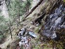
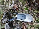
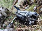
The target was a fallen tree, which should lie next to the suspected MPP, with branches pointing to it. Again, 3D vs. 2D. The tree was huge, its branches were high up in the air, but after climbing over it, after more than two years, the missing MPP came into my view. It lay there, framed by a couple of small rocks and – surprise – had not been smashed into pieces. Midair shutdown altitude was 60m/180ft above HP, but approx. 260m/780ft AGL of the crash site.

MPP-1s.jpg

MPP-2s.jpg

Condition:

Upright position
3 arms were folded, 1 arm broken but still hanging on its cables.
2 props were gone, 1 prop blade and one complete prop in almost perfect shape were still attached.
The gimbal was separated from the body with the camera and ND-Filter still connected. Strange for me, the cable isolation has completely disappeared, only blank wires were left.
The battery has some dents and small holes but is still sitting on the AC.

Reg. folded arms, my assumption would be that during the free fall, it must have crashed against the rock wall. The broken arm probably was in oposite rotation direction and therefore could not fold away.

There was dirt and plants all over and partially inside the AC. See image where AC was already lifted and turned around.

MPP-3s.jpg


Finally, I managed to climb up again with expected big difficulies at spots where I slipped before. (therefore never again – at least without more intensive training).

At home, a functional test showed following results:

Battery sits extremely tight, removed with tool-support
Startup with new battery showed the familiar sound at startup.
No gimbal reaction, no camera life feed
Starting the motors: front left, back right (broken arm) ok
front right, back left dead
Fan started after a while
LED signals not further evaluated

Given the 2 years in the harsh climate of the mountains, this robustness is remarkable.

Last but not least: SD card could not be read at first. Chemical cleaning of connections solved the problem, footage saved!

I do not intend to attempt a repair, but will keep it as is to remember a really weird flight, pushing and thereby exceeding the physical limits of the AC..
 
Lycus Tech Mavic Air 3 Case

DJI Drone Deals

New Threads

Forum statistics

Threads
130,584
Messages
1,554,099
Members
159,588
Latest member
gfusato