

I know, but you need to tell us what direction that was. In which direction did it fly away, and which hills do you keep referring to?The aircraft was flying fine during my first flight, check my reply PhillusFogg. The drone turn around after disconnection and flew away from me like it had another homeport in its system ( as hard as that is to believe).
You are using an out of date browser. It may not display this or other websites correctly.
You should upgrade or use an alternative browser.
You should upgrade or use an alternative browser.
My Mavic 3 flew away - Any Help Please with Location
- Thread starter Suren
- Start date
- Status
- Not open for further replies.
So this is a drone issue as I suspect. I did tell the dealer I have a lemon because of all the vision sensor issues I was having and they said the firmware update will fix this.Can also add in this ...
The velocity difference between the GPS & IMU takes a turn to the worse at 150sec into the flight, pink area in the chart is the period when you make the dronie, circle & pitch up+fly forward.
Something is clearly going on ... this can possibly indicate IMU problems ...
View attachment 141552

That is very strange as my max altitude is set at 306 meters and RTH is set at 52 meters. Something is not looking right here.I not challenging your knowledge or statement but at 3:50 of the video it shows this
View attachment 141553
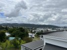
If you check this picture the hills in the distance is where it was flying towards. I lost it at the bottom there, could not see it anymore.I know, but you need to tell us what direction that was. In which direction did it fly away, and which hills do you keep referring to?
Attachments
Those number are both correct as set for that flight.That is very strange as my max altitude is set at 306 meters and RTH is set at 52 meters. Something is not looking right here.
Okay - so it was facing SE when your device disconnected, and then it flew away (backwards?) towards the NW. You mentioned previously that it turned around - did you actually see it rotate, or was that just a figure of speech?If you check this picture the hills in the distance is where it was flying towards. I lost it at the bottom there, could not see it anymore.
The hills to the NW are 2 km from the home point - did you actually follow it and observe it fly over those hills - i.e. you drove after it in your vehicle and somehow regained visual contact with it? Which road were you on?
D
Deleted member 103366
Guest
The values shown at 3:50 are the default value for the app when the app is not connected to the controller.That is very strange as my max altitude is set at 306 meters and RTH is set at 52 meters. Something is not looking right here.
Because the drone was so close to me I could see it. When it disconnected the drone hovered in place for a few seconds and did nothing then it turned around and flew towards those hills. I had visual site of it when driving hoping it would reconnect but the RC kept flashing and screen was blank. I lost sight of the drone at those hills as I could not proceed any further by car.Those number are both correct as set for that flight.
Okay - so it was facing SE when your device disconnected, and then it flew away (backwards?) towards the NW. You mentioned previously that it turned around - did you actually see it rotate, or was that just a figure of speech?
The hills to the NW are 2 km from the home point - did you actually follow it and observe it fly over those hills - i.e. you drove after it in your vehicle and somehow regained visual contact with it? Which road were you on?
Ah, that makes senseThe values shown at 3:50 are the default value for the app when the app is not connected to the controller.
Etdronehome
Well-Known Member
OK thanks. I use those limits to keep drone within my VLOS. I thought perhaps one of the auto - picture modes overrides the limit(s).It's disconnected by then. The max height was 306 m throughout the flight - it's one of the logged parameters.
Yep, aware about the scale... but at 150sec the pattern change compared to earlier in the flight.No - you have to pay attention to the scale - those numbers are very small and well within expected bounds:
View attachment 141554
But as said... too little data, all is up for speculation, perhaps DJI can see more in the encrypted mobile device DAT log.
Okay - well if you had confirmed visual on the drone flying off to the NW and going further than those hills then that is a quite inexplicable failure that I've certainly never seen before. And since it was at 132 m AMSL it did not have the altitude to clear the hills unless it also climbed. It should have returned home on either disconnect or low battery.Because the drone was so close to me I could see it. When it disconnected the drone hovered in place for a few seconds and did nothing then it turned around and flew towards those hills. I had visual site of it when driving hoping it would reconnect but the RC kept flashing and screen was blank. I lost sight of the drone at those hills as I could not proceed any further by car.
I apologize for having to ask, but are you quite certain that you were following your aircraft when you drove after it?
That is unusual - VPS was disabled for the entire recorded flight.Can anyone also explain how the drone vision system assumed it was night and gave that error message at the beginning of the flight.
The IMU/GPS discrepancy changes when it starts moving - that's not unusual. Here are the same data visualized in position space - the data clearly show that the IMU is fine:Yep, aware about the scale... but at 150sec the pattern change compared to earlier in the flight.
But as said... too little data, all is up for speculation, perhaps DJI can see more in the encrypted mobile device DAT log.

So if it did not clear the height it might be some where in the forest still, will need to spend some time combing those hills. Yes I had my eye on it( well my son did) as I was driving and I saw it fly by the hill which is where is topped with the car. When you say the VPS was disabled for the entire flight, where did you see that. How could that be possible because the ap was set to bypass?Okay - well if you had confirmed visual on the drone flying off to the NW and going further than those hills then that is a quite inexplicable failure that I've certainly never seen before. And since it was at 132 m AMSL it did not have the altitude to clear the hills unless it also climbed. It should have returned home on either disconnect or low battery.
I apologize for having to ask, but are you quite certain that you were following your aircraft when you drove after it?
That is unusual - VPS was disabled for the entire recorded flight.
Yes, that is what it is set for and did work during my first flight this morning when it disconnected.Isn't it suppose to RTH on disconnect?
Is it not the default?
That is the default and it's uncommon for users to change it.Isn't it suppose to RTH on disconnect?
Is it not the default?
But there are many things that can prevent a drone returning such as wind, obstacles, insufficient battery, hardware failure etc.
I've seen it happen before where someone mistook a different drone for their own during flight. Ended badly, of course. An unusual event of course, but not as unusual as the alternative - that it just took off by itself away from the home point. Is that possible here or would you completely rule it out?So if it did not clear the height it might be some where in the forest still, will need to spend some time combing those hills. Yes I had my eye on it( well my son did) as I was driving and I saw it fly by the hill which is where is topped with the car.
OSD.isVisionUsed = FALSE for the entire flight. No reason given in the TXT log.When you say the VPS was disabled for the entire flight, where did you see that. How could that be possible because the ap was set to bypass?
@slup - has anyone actually checked to see if the M3 mobile device DAT files are readable, or is it just being assumed that they are not?
Fully understand your need of answers... but with the limited data we have, your best bet will be DJI & their access to the mobile device DAT log... both when it comes to the cause & where it might have ended up.
The below video is from my first flight today and is evident there was an issues. As you will see it only reconnects above me
- Status
- Not open for further replies.
Similar threads
- Replies
- 13
- Views
- 1K
- Replies
- 23
- Views
- 1K
- Replies
- 5
- Views
- 955


DJI Drone Deals
New Threads
-

-
-
-
Air 3 The Battle of Bannockburn
- Started by Coconut Island Drones
- Replies: 0
-

Members online
Total: 2,750 (members: 13, guests: 2,737)
Forum statistics
