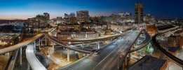
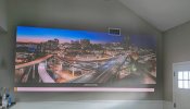
Appreciate all the comments. I believe the trail is called the Floodwall trail and is mixed use. There is a spot where you can launch and fly directly up between multiple elevated roads and railways. No need to even use the right stick.
For this pano I actually shot on Auto using the Pano mode because there was a bit of sunset sky glow to the left and complete shadows to the right. Shutter speeds were 1/8s to 1/12s, iso floated around 1100 to 1340. Exposure bias was +0.3 step. The dng files were pretty dark so what the heck... try the new Adobe Adaptative profile. You should have it if you are on the subscription model. Open an image in Lightroom, I selected Adaptive profile from the Profile dropdown menu, instantly better image. Then: Shadows +21, Temperature 5500, tint 0, vibrance +10, saturation +9, Texture +6 and Yellow Saturation -80 for the city lights. I used those settings to create a preset that I just applied to the rest of the images. Finally, Denoise amount set to 40 and export all images as tiffs. Then I used the free Autopano Giga 4.4 to arrange and render. For whatever reason, the 10th image was not readable by the software when I imported .dng files. Total 24 images with the 3x camera.
BTW, if anyone knows where I could get documentation for Autopano 4.4, it would be much appreciated.


