DJI Mavic, Air and Mini Drones
Friendly, Helpful & Knowledgeable Community
Join Us Now

rgprints

New Member
Joined
Jan 14, 2021
Messages
3
Reactions
13
Age
77
Location
Blue Bell, PA 19422 USA
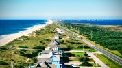
While on vacation in Frisco on Hatteras Island in the Outer Banks a couple of weeks ago I took some photos with my Mini 2. This is my favorite. It shows how very narrow the Outer Banks are in some (many) places. Understandably, all it takes is a major storm to cut right through some of these spots and create new islands by cutting one off the mainland or in the location shown below, by cutting an island in half.

On the left is the Atlantic and on the right is Pamlico Sound. The houses in the forefront are the west edge of Frisco and the houses in the distance make up the town of Hatteras.

The dunes along the left (the lumpy vegetated bumps along the beach) were man made by the WPA during the Depression (in 1933 or so). There are natural dunes in some other places of the Outer Banks, the most notable being Jockey's Ridge and the nearby dunes from which the Wright Brothers launched their flights. However, many people don't know that most of the dunes on the Outer Banks, particularly the ones protecting the sea-front houses and that we see on the evening news as having been washed away by nor'easters and hurricanes were man made nearly a century ago.

The road is NC Highway 12 that runs the length (148 miles) of the Outer Banks and includes several ferry crossings. The town of Hatteras, in the distance, is at the far end of Hatteras Island and to continue from there by ferry to the Island of Ocracoke where NC 12 continues takes about 45 minutes to an hour, depending on conditions and not including the hour (or more) wait for the ferry.

The picture was automatically post processed in Photos.Google by the Google Assistant and suggested as an enhancement.

FYI, this more or less duplicates a post I made in Ugly Hedgehog, so apologies if you've encountered it twice.Photo_6553822_DJI_222_jpg_4602470_0_20211016102822_photo_original-EFFECTS.jpg
 
Thanks for posting the photo, I only looked this up on Google maps the other day as one of the forum members in NC mentioned he is going there soon on holiday.
I was thinking it'd be a really interesting drive & ferry road trip.
It is a very interesting drive. Be aware that there can be long waits to get onto a ferry. Some ferries have reservations, some don't and are sort of first come first serve. When we were there a couple of weeks ago we thought we might take the Hatteras to Ocracoke ferry for a day trip to Ocracoke. After waiting through one ferry departure and moving up in line to get on we were about ready to board the next ferry when I found out that only 2 of the 4 ferries normally used on that crossing were out of service. So we decided to abandon our plans as I was quite concerned about being able to catch the return ferry.

Also know that on the Hatteras-Ocracoke ferry residents of Ocracoke and almost all commercial traffic (UPS trucks, plumbers, heating oil trucks, etc.) have priority and have their own waiting line. Sometimes it happens that there are so many cars and trucks in the priority line that they fill the ferry and everyone else has to wait for the next one. Of course during that waiting period (half hour or hour depending on the current schedule) more priority traffic will arrive.

That last bit entered into my reasoning for abandoning our plans that day as I could foresee that for the return trip I might have to sit through 3-4-5 departures (or more!) if the priority traffic filled each ferries because overall capacity was only half the usual.

The NC DOT has a website with information on all of the ferries that could be very useful to you: NCDOT: Ferry Schedule
 
While on vacation in Frisco on Hatteras Island in the Outer Banks a couple of weeks ago I took some photos with my Mini 2. This is my favorite. It shows how very narrow the Outer Banks are in some (many) places. Understandably, all it takes is a major storm to cut right through some of these spots and create new islands by cutting one off the mainland or in the location shown below, by cutting an island in half.

On the left is the Atlantic and on the right is Pamlico Sound. The houses in the forefront are the west edge of Frisco and the houses in the distance make up the town of Hatteras.

The dunes along the left (the lumpy vegetated bumps along the beach) were man made by the WPA during the Depression (in 1933 or so). There are natural dunes in some other places of the Outer Banks, the most notable being Jockey's Ridge and the nearby dunes from which the Wright Brothers launched their flights. However, many people don't know that most of the dunes on the Outer Banks, particularly the ones protecting the sea-front houses and that we see on the evening news as having been washed away by nor'easters and hurricanes were man made nearly a century ago.

The road is NC Highway 12 that runs the length (148 miles) of the Outer Banks and includes several ferry crossings. The town of Hatteras, in the distance, is at the far end of Hatteras Island and to continue from there by ferry to the Island of Ocracoke where NC 12 continues takes about 45 minutes to an hour, depending on conditions and not including the hour (or more) wait for the ferry.

The picture was automatically post processed in Photos.Google by the Google Assistant and suggested as an enhancement.

FYI, this more or less duplicates a post I made in Ugly Hedgehog, so apologies if you've encountered it twice.View attachment 137421
Have to be extremely careful when flying on South Hatteras - as it is National Park on much of it from Nags Head down to Frisco. There are splotches of open area along the route; but so much of it is RESTRICTED. Most open areas are around towns and places with homes, but always check B4UFLY / Aloft / etc to make sure.

Took the ferry over (did wait like an hour or more and got there early - but a line already) to Ocracoke. It's okay, but a very small place with not a lot to see /do. Did get the drone up and flew near the Ocracoke Lighthouse (which is park property) and some shots of the bay / inlet area. The route the ferry takes is quite circuitous, as it follows a channel deep enough to not hit bottom.

Flying on north side of Hatteras is almost wide open except at NC State Parks (Jockeys Ridge Sand Dune) and Wright Brothers Museum / park. The Currituck Lighthouse in Corolla is private, so flying it is fine. Also Carova 4x4 beach and the wild horses is cool too.

Hope to be there soon.
 
Nice place to visit but wouldn’t want to live there. We have the same situation where I live in Florida, people living on sandbars. All of us subsidize the flood insurance and beach renourishment for beachfront homes and highrise condos. Then they block the beach access and the view. Bummer
Anyways, nice picture 😎
 
Lycus Tech Mavic Air 3 Case

DJI Drone Deals

New Threads

Members online

Forum statistics

Threads
131,127
Messages
1,560,117
Members
160,099
Latest member
tflys78