DJI Mavic, Air and Mini Drones
Friendly, Helpful & Knowledgeable Community
Join Us Now

Official DJI Response to the GPS Issue

All GPS satellite systems are open access.
There is no licensing.
Ripped right from the FCC - "The Federal Communications Commission (FCC) rules require licensing of non-federal receive-only equipment operating with foreign satellite systems, including receive-only earth stations operating with non-U.S. licensed radionavigation-satellite service (RNSS) satellites."

There is a waiver process to waive this requirement; on November 15, 2018, the European Union received the first waiver of the FCC's licensing requirements under the process described above.
That requirement primarily restricts the use of non-US un-waivered GNSS signals services such as E911. It's not a requirement for legal personal use of a multi-system receiver such as on a drone.
 
That requirement primarily restricts the use of non-US un-waivered GNSS signals services such as E911. It's not a requirement for legal personal use of a multi-system receiver such as on a drone.
It was for consumer devices for "regular stuff". You can see mention in the report associated with that waiver that it was for the E1 and E5 bands of Galileo; E911 was specifically called out in the report as not being allowed via the waiver; additional requirements needed to be met for E911. The FCC press release at the time said:

"With today’s action, consumers and industry in the United States will now be permitted to access certain satellite signals from the Galileo system to augment the U.S. Global Positioning System (GPS), and thus benefit from improved availability, reliability, and resiliency of these position, navigation, and timing services in the United States."

Broadcom and Qualcomm petitioned the FCC with regard to PNT services, which is the broad set of services we enjoy on our mobile devices and other navigation systems, beyond the narrower E911 service.
You are correct that technically a waiver or license is required in the US for any receiver to receive foreign satellite signals, but as far as I can tell it's never been enforced with consumer GNSS devices, especially as used in drones. Some manufacturers (especially mobile phones) have in the past implemented some form of geofencing to ignore Galileo or BeiDou signals (although not GLONASS) but I would be very surprised if DJI did that.
 
You are correct that technically a waiver or license is required in the US for any receiver to receive foreign satellite signals, but as far as I can tell it's never been enforced with consumer GNSS devices, especially as used in drones. Some manufacturers (especially mobile phones) have in the past implemented some form of geofencing to ignore Galileo or BeiDou signals (although not GLONASS) but I would be very surprised if DJI did that.
Yes, the author of GPS Test has a blog post from a while ago about a user discovering geofencing was likely implemented for Galileo on their phone, as they could see Galileo sats listed in Europe on their device, but not in the US. I'd guess that GLONASS was effectively, quietly, grandfathered in as it's use pre-dated the FCC rule implementation.

I would also be surprised if DJI geofenced out BeiDou in the US, and without mentioning it. They have previously released products specifically with either BeiDou for Asia and GLONASS for every other market, but given the timeframe of those product releases, it was before BeiDou 3 was fully implemented and thus probably necessary, due to lack of Global coverage.

I'm getting ever closer to just seeing if I can tap into the GNSS chip itself inside the M3 while operating, to see wtf is going on :)
Just as a sanity check I looked through a number of M3 log files. Not statistically conclusive, but none of the US logs I found show more than around 20 satellites locked, while those elsewhere in the world are closer to 30. Perhaps the M3 GNSS chip is ignoring the BeiDou constellation when operated in the US.
 
Last edited:
  • Like
Reactions: BigAl07
Just as a sanity check I looked through a number of M3 log files. Not statistically conclusive, but none of the US logs I found show more than around 20 satellites locked, while those elsewhere in the world are closer to 30. Perhaps the M3 GNSS chip is ignoring the BeiDou constellation when operated in the US.
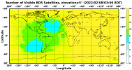
Without the breakdown of what constellation those 20 satellites belong to, hard to gauge if that is the case, unfortunately. However, taking the coverage map from the BeiDou website for today:

W020220208432993476091.png

Shows that most of the US sees 8-10 at an elevation threshold of >=5 degrees, and the rest of the world sees 12-16, so that delta of 2-8 added to what you see in US logs also takes it "closer to 30". The discrepancy may be related to the fact the rest of the world just see more, rather than BeiDou being ignored in the USA, but without knowing the specifics of what those sats are and the elevation threshold DJI configured, hard to gauge.
 
Without the breakdown of what constellation those 20 satellites belong to, hard to gauge if that is the case, unfortunately. However, taking the coverage map from the BeiDou website for today:

View attachment 143607

Shows that most of the US sees 8-10 at an elevation threshold of >=5 degrees, and the rest of the world sees 12-16, so that delta of 2-8 added to what you see in US logs also takes it "closer to 30". The discrepancy may be related to the fact the rest of the world just see more, rather than BeiDou being ignored in the USA, but without knowing the specifics of what those sats are and the elevation threshold DJI configured, hard to gauge.
Yes - it could be just the difference in coverage. The DAT file will be reporting the numbers of each individual system, but unfortunately that's not currently readable.
 
It may be just a translation/second language thing, but "hardware fault issue discovered in the Mavic 3 involving GPS unit failure" may be referring to a completely different issue.

I wouldn't characterize the slow acquisition time as a hardware fault, particularly if it arose after a firmware update. And there have been many instances where DJI customer service reps completely misunderstood the question or issue.
 
  • Like
Reactions: Meta4
It may be just a translation/second language thing, but "hardware fault issue discovered in the Mavic 3 involving GPS unit failure" may be referring to a completely different issue.

I wouldn't characterize the slow acquisition time as a hardware fault, particularly if it arose after a firmware update. And there have been many instances where DJI customer service reps completely misunderstood the question or issue.
And if there is a hardware fault in the M3 then obviously they will be replacing them, not offering $100 for the inconvenience.
 
And if there is a hardware fault in the M3 then obviously they will be replacing them, not offering $100 for the inconvenience.

You have more faith in them than I do. Totally sounds like something they'd do to me, "Here's a hundred DJI bucks, enjoy your broken drone. Thank you for your supportings and understandments".
 
  • Like
Reactions: langcpht and Meta4
You have more faith in them than I do. Totally sounds like something they'd do to me, "Here's a hundred DJI bucks, enjoy your broken drone. Thank you for your supportings and understandments".
It's not a matter of faith. Firstly - a widespread hardware problem in a critical system would kill the sales of that model, especially if DJI simply offered a token compensation rather than fixing or replacing affected units. Secondly, I've had the opportunity to watch numerous cases of firmware and hardware problems, and DJI doesn't do anything like you suggested.
 
Well, as long as it was "inentional" I suppose it's ok. Hah.

Did anyone have a problem with the accuracy of home points prior to the update? Did it need optimizing?
I'm not sure about my Mavic 3 yet, but I am certainly having very scary RTH issues with my M2P.
Last map I did, drone landed in middle of construction site instead of where it took off - this is new as it always came straight back to the RTH spot
 
I'm not sure about my Mavic 3 yet, but I am certainly having very scary RTH issues with my M2P.
Last map I did, drone landed in middle of construction site instead of where it took off
That won't be a problem with GPS hardware or software.
The most likely explanation would be that the homepoint was not set at your launch point, but was recorded as you flew out, right above the place where the drone landed.
It should be easy to confirm if this was the case with the recorded flight data.

If you ever find yourself in a similar situation, it quick and easy to cancel the automated flight or landing by flicking the flight mode switch out of P-GPS and back again and land the drone manually wherever you want it to go.
 
  • Like
Reactions: calmar81
You have more faith in them than I do. Totally sounds like something they'd do to me, "Here's a hundred DJI bucks, enjoy your broken drone. Thank you for your supportings and understandments".
The email above is fake it was posted first on the DJI forum (not by Suren). It has now been debunked by DJI who have said there is no problem with their hardware. Incidentally the guy who originally posted it has been banned from DJI forum 3 times in the last week.🤣 Although he’s still very much present on this forum. DJI are advising those who are having longer waiting times of 2/3 minutes to contact them with logs and video.
 
  • Like
Reactions: Suren and oztx
Lycus Tech Mavic Air 3 Case

DJI Drone Deals

New Threads

Forum statistics

Threads
131,392
Messages
1,562,736
Members
160,318
Latest member
hippysmavic