


You are using an out of date browser. It may not display this or other websites correctly.
You should upgrade or use an alternative browser.
You should upgrade or use an alternative browser.
Official Mavic Pro Range Leaderboard!
- Thread starter Long Ranger
- Start date


I assume that flights are always out and back? IOW, just going as far as you can beyond the battery RTH point (if you still have a connection) isn't included here?
As mentioned, my flightlog was corrupted. I'm currently extracting the data from mavic with a Datcon and CSViewer app. I have the data, but can't get the google API to work correctly to show map data. I'll upload later when I have time to finish extracting flight data.
The flight was about 89,000 ft in total.
Thanks Nate (and WOW!)As mentioned, my flightlog was corrupted. I'm currently extracting the data from mavic with a Datcon and CSViewer app. I have the data, but can't get the google API to work correctly to show map data. I'll upload later when I have time to finish extracting flight data.
The flight was about 89,000 ft in total.
I worded my question poorly... I was asking in general, not your flight specifically. I.e. the 20 leaders in the first post -- those are all out and back, right?
Natedoggz
Well-Known Member
- Joined
- Jan 25, 2017
- Messages
- 180
- Reactions
- 75
- Age
- 43
How much power was left in those hv's after flight, im about to take the plunge on those, and with my hardwired MP if it would match my mavic perfectly (also a couple posts back I seen the sacrifice a MP battery and thinking hmmmm combine those two options and see what I can get) wishful thinking!I keep the tachometer/power below 80% and usually between 60-70%. I don't push the motors too hard this way and get the maximum efficiency out of the batteries. I don't see any issue with running 4000mah batteries as long as you don't push the motors beyond 80%. This means you need to be careful with ascents, reducing pitch and also not flying in excessive winds. I had to slow to 13 mph at points to keep the tach below 80%. Great thing about going into the wind is I can always turn around and ride the wind back. I had low wind going out until half way out, but once I got close to the bay, the wind picked up drastically, but I managed by motor speed to avoid stress. On the way back I went 40mph all way and only used 35% battery for 44,500ft, leaving mavic at 11% (turn around at 46%).
Here are the pictures. Yes, they are HUGE compared to the 3000s
View attachment 13552
View attachment 13551
View attachment 13550
How much power was left in those hv's after flight, im about to take the plunge on those, and with my hardwired MP if it would match my mavic perfectly (also a couple posts back I seen the sacrifice a MP battery and thinking hmmmm combine those two options and see what I can get) wishful thinking!
3.69v/cell. So in the end it was the battery, not the clip. The lipo version would be at 3.75v it higher. The multistar lipos are terrible, while their LiHV are excellent.
How much power was left in those hv's after flight, im about to take the plunge on those, and with my hardwired MP if it would match my mavic perfectly (also a couple posts back I seen the sacrifice a MP battery and thinking hmmmm combine those two options and see what I can get) wishful thinking!
The batteries took 3800 each, which about right for 11% remaining on Mavic battery.
So I went out for a long run today. I reached somewhere around 44,500 feet, but I had very bad signal today. Somehow my flight log just stopped recording at 30,626.8ft out, perhaps because of the poor signal? My last entry in the flight log has me out over 30,000ft with 69% battery remaining. Is there another place to extract the log, perhaps off the Mavic itself? I pushed the mavic to 46% battery before turning around. I had a STRONG headwind come on and at points was only going 13mph. I think on a good day, 50,000 might be possible. This was with my dual 4000mah LIHV batteries that I just received.
Here is where my flight log cut off
View attachment 13546
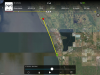
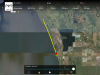
Ok, so I was able to get the DAT file off of the Mavic directly and view the entire flight path. Unfortunately I don't see distance shown, but using google maps to map the same, I get just under 45,000, like 44,900ft.
Here is the path from DAT file on Mavic:

Here is the path mapped on Google Maps for measuring distance:

8.51 miles is 44,943ft or 13.696 meters.
Anyone know how to properly read DAT files? Seems like a useful tool with a lot of information. I just can't get it to display everything I want. There must be a way to show the precise distance, perhaps longitude and latitude start and end.
digdat0
Well-Known Member
- Joined
- Oct 30, 2016
- Messages
- 298
- Reactions
- 278
- Age
- 45
Ok, so I was able to get the DAT file off of the Mavic directly and view the entire flight path. Unfortunately I don't see distance shown, but using google maps to map the same, I get just under 45,000, like 44,900ft.
Here is the path from DAT file on Mavic:
View attachment 13570
Here is the path mapped on Google Maps for measuring distance:
View attachment 13569
8.51 miles is 44,943ft or 13.696 meters.
Anyone know how to properly read DAT files? Seems like a useful tool with a lot of information. I just can't get it to display everything I want. There must be a way to show the precise distance, perhaps longitude and latitude start and end.
postup the data file and send me the link, i should be able to make you a KML file so you can use in Google earth.
Also in the converted data file there should be a column named distanceHP find this and the farthest distance is the number you want. This file may be in meters, so be sure to multiply it. I've spent alot of time in the logs
")
The signal you want is distanceTravelled(M) for total distance. distanceHP(M) will give the distance to the home pointOk, so I was able to get the DAT file off of the Mavic directly and view the entire flight path. Unfortunately I don't see distance shown, but using google maps to map the same, I get just under 45,000, like 44,900ft.
Here is the path from DAT file on Mavic:
View attachment 13570
Here is the path mapped on Google Maps for measuring distance:
View attachment 13569
8.51 miles is 44,943ft or 13.696 meters.
Anyone know how to properly read DAT files? Seems like a useful tool with a lot of information. I just can't get it to display everything I want. There must be a way to show the precise distance, perhaps longitude and latitude start and end.
dirtybum
Well-Known Member
- Joined
- May 4, 2017
- Messages
- 538
- Reactions
- 460
- Age
- 49
postup the data file and send me the link, i should be able to make you a KML file so you can use in Google earth.
Also in the converted data file there should be a column named distanceHP find this and the farthest distance is the number you want. This file may be in meters, so be sure to multiply it. I've spent alot of time in the logs
I've never seen somebody post a Dat file to prove their distance record! I think your best bet is to try again and hope your logs/screenshots/air data works out for you next time, we've all been there, most distance flyers you talk to have been skunked by a bad or missing flight log.[emoji41]
This was your first run with those good batteries, they're only going to get better, you will re-create it again this week
Ok, so I was able to get the DAT file off of the Mavic directly and view the entire flight path. Unfortunately I don't see distance shown, but using google maps to map the same, I get just under 45,000, like 44,900ft.
Here is the path from DAT file on Mavic:
View attachment 13570
Here is the path mapped on Google Maps for measuring distance:
View attachment 13569
8.51 miles is 44,943ft or 13.696 meters.
Anyone know how to properly read DAT files? Seems like a useful tool with a lot of information. I just can't get it to display everything I want. There must be a way to show the precise distance, perhaps longitude and latitude start and end.
Ok, not as good as I measured with Google. I reached 13501m (44295 ft) distance from home and 27,043m ((88,724ft) total distance:


@JakeMaxxUAV pencil me in for 44,295ft. I upgraded my batteries to LiHV.
I've never seen somebody post a Dat file to prove their distance record! I think your best bet is to try again and hope your logs/screenshots/air data works out for you next time, we've all been there, most distance flyers you talk to have been skunked by a bad or missing flight log.[emoji41]
This was your first run with those good batteries, they're only going to get better, you will re-create it again this week
Yes, I know. I just like tinkering with the dat file and software. I'm relatively new to this hobby. Nice to have a new tool to use. This record is weak sauce. Someone needs to push this up to the high 40K near 50K.
dirtybum
Well-Known Member
- Joined
- May 4, 2017
- Messages
- 538
- Reactions
- 460
- Age
- 49
Ok, not as good as I measured with Google. I reached 13501m (44295 ft) distance from home and 27,043m ((88,724ft) total distance:
View attachment 13571
View attachment 13572
@JakeMaxxUAV pencil me in for 44,295ft. I upgraded my batteries to LiHV.
I like what I've seen and learned from you so far, and completely nothing personal, but just fly it again and repost. Yer flight prob stands up and will easily be recreated, but many of yer piers have had this issue and chalked it up to bad luck! No DJI log,no screenshot, no airdata. Just redo the flight.
You got the skills! Some of the flyers on this thread, from the other a/c's have scratched flights for running out of juice 200' from homepoint! So "pencil me in" on an incomplete log seems pointless. Again nothin personal & I'm a new fan.
Jakes requirements/requests in post#1

Unknown Caller
Well-Known Member
- Joined
- Feb 28, 2017
- Messages
- 93
- Reactions
- 126
- Age
- 47
Cybernate I'm sorry that happened to you bro. DB and me have had that happen to us a couple times before ourselves. That's a great flight right there bro. I'm sure on your next flight you go even further.
Unknown Caller
Well-Known Member
- Joined
- Feb 28, 2017
- Messages
- 93
- Reactions
- 126
- Age
- 47
**** I just got done flying the mavic I made it out to 45,600 turned it 48% I was only 2500 feet away from home and I accidentally let it landit was still dark didn't realize how low I was. Lol that was a really good run 2 it's a shame. I only use my single 5200 again getting pretty good battery life out of just that battery. Can't wait to get batteries I ordered hopefully redeem this flight.
Attachments
Last edited:
**** I just got done flying the mavic I made it out to 45,600 turned it 48% I was only 2500 feet away from home and I accidentally let it land. Lol that was a really good run 2 it's a shame. I only use my single 5200 again getting pretty good battery life out of just that battery. Can't wait to get batteries I ordered hopefully redeem this flight.
Wow! You nailed it on that flight! How did you let it land? You had plenty of battery left to make it. You must have been flying low. Nice flight. Now we're getting to some serious range.
Unknown Caller
Well-Known Member
- Joined
- Feb 28, 2017
- Messages
- 93
- Reactions
- 126
- Age
- 47
Look at the altitude almost nine miles 62 ft. Stock controller I think that's crazy!!!
Look at the altitude almost nine miles 62 ft. Stock controller I think that's crazy!!!View attachment 13668
Yes, very good! You have the perfect spot there. Are you running the lipo version of multistar? I think you are. You definitely should get an Lihv. Or maybe you shouldn't. You need a handicap ;-).
Unknown Caller
Well-Known Member
- Joined
- Feb 28, 2017
- Messages
- 93
- Reactions
- 126
- Age
- 47
Dark out still let off the stick didn't realize until I was on the groundWow! You nailed it on that flight! How did you let it land? You had plenty of battery left to make it. You must have been flying low. Nice flight. Now we're getting to some serious range.
Similar threads
- Replies
- 11
- Views
- 1K
- Replies
- 0
- Views
- 1K
- Replies
- 10
- Views
- 2K
- Replies
- 6
- Views
- 1K


DJI Drone Deals
New Threads
-
-
-
-

-
 3 From Govedartsi to Mechit peak and back
- Started by alex_markov
- Replies: 4
Forum statistics
