Greetings,
We recently released a new update of our free and open source OpenAthena™ for Android app which contains some significant new features.
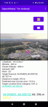
The app introduces a novel terrain-raycast technique which allows you to instantly obtain a precise ground location for any single pixel of any single drone image:


The software can enhance the use of drones for many use cases such as search and rescue, public safety, law enforcement, agriculture, land management and more. It excels wherever speed and accuracy of location calculation are key.
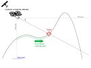
The software's terrain-raycast technique fuses the sensor metadata embedded within drone images with a digital elevation model (which represents the height of terrain) to calculate a precise ground location for any pixel of an image. It allows drones without a laser rangefinder to achieve a similar functionality for location calculation from remote sensing.
New in v0.21.0 is an AutoDEM feature which may download and manage elevation model files automatically. This means that you can tap to locate within your drone image immediately after loading it within the app (and the app downloads an elevation model of the surrounding area). We've noticed this is a significant usability improvement which makes it much easier to operate out in the field.
Some older DJI drone models are not compatible with this app due to their metadata format. The following drones are known to be incompatible:

 github.com

 github.com
The OpenAthena app is free and open source software and is available on Google Play and the Apple App Store:


We develop the project out in the open on GitHub, where any developer can inspect the code and propose their own modifications to it. This is our key differentiator, where we can advance the technology faster and provide better support and features through a collaborative, community-led development effort:

 github.com
Rather than software sales, our primary business interest is support and customization around the software as well as technology licensing for paid clients.
We're cant wait to hear what you can do with this technology! We're reachable at any time via the email [email protected] and would love to hear about your experience with the program
We recently released a new update of our free and open source OpenAthena™ for Android app which contains some significant new features.
The app introduces a novel terrain-raycast technique which allows you to instantly obtain a precise ground location for any single pixel of any single drone image:


The software can enhance the use of drones for many use cases such as search and rescue, public safety, law enforcement, agriculture, land management and more. It excels wherever speed and accuracy of location calculation are key.
The software's terrain-raycast technique fuses the sensor metadata embedded within drone images with a digital elevation model (which represents the height of terrain) to calculate a precise ground location for any pixel of an image. It allows drones without a laser rangefinder to achieve a similar functionality for location calculation from remote sensing.
New in v0.21.0 is an AutoDEM feature which may download and manage elevation model files automatically. This means that you can tap to locate within your drone image immediately after loading it within the app (and the app downloads an elevation model of the surrounding area). We've noticed this is a significant usability improvement which makes it much easier to operate out in the field.
Some older DJI drone models are not compatible with this app due to their metadata format. The following drones are known to be incompatible:
- DJI Phantom 4 (not inc. Pro or Advanced versions, FC330 only)
- DJI Mini 2
- DJI Mini 3 (not inc. Pro version)
- DJI Air 2 S (old firmware)
GitHub - Theta-Limited/camera-calibration: Python script for manual camera calibration using OpenCV with images of a B/W Chessboard pattern
Python script for manual camera calibration using OpenCV with images of a B/W Chessboard pattern - Theta-Limited/camera-calibration
DroneModels/droneModels.json at main · Theta-Limited/DroneModels
Contribute to Theta-Limited/DroneModels development by creating an account on GitHub.
The OpenAthena app is free and open source software and is available on Google Play and the Apple App Store:


We develop the project out in the open on GitHub, where any developer can inspect the code and propose their own modifications to it. This is our key differentiator, where we can advance the technology faster and provide better support and features through a collaborative, community-led development effort:
GitHub - Theta-Limited/OpenAthenaAndroid: OpenAthena allows common drones to spot precise geodetic locations
OpenAthena allows common drones to spot precise geodetic locations - Theta-Limited/OpenAthenaAndroid
Rather than software sales, our primary business interest is support and customization around the software as well as technology licensing for paid clients.
We're cant wait to hear what you can do with this technology! We're reachable at any time via the email [email protected] and would love to hear about your experience with the program


