


Attention Litchi and Google Earth Pro users:
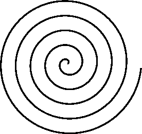
A type of mission that I like to fly when capturing video is a "spiral reveal". This is where the drone revolves around a point of interest (POI) while gaining in altitude. Geometrically, this is probably better described as a "coil" or "helix". Even though you can manually design such a mission in Litchi, it is difficult to get a perfect circle, spiral, or coil in a waypoint mission. Dronelink has an “Orbit” component that does this. However, Litchi does not.
I’ve created an application that takes a kml file from Google Earth Pro and converts it into a csv file that can be imported into Litchi as a waypoint mission, giving you a perfectly circular path. It allows you to specify the starting, ending, and POI height then generates a path and gimbal pitch angles based on those (and other) parameters making the whole process rather easy.
Since I am a software developer and do a bit of web development, I decided to take this stand-alone application and turn it into a web application that you can use.
My general workflow is this:
If interested please give it a try. I am open to feedback and would like to see any videos where you used this to help generate your mission. The URL of this web application is:
A type of mission that I like to fly when capturing video is a "spiral reveal". This is where the drone revolves around a point of interest (POI) while gaining in altitude. Geometrically, this is probably better described as a "coil" or "helix". Even though you can manually design such a mission in Litchi, it is difficult to get a perfect circle, spiral, or coil in a waypoint mission. Dronelink has an “Orbit” component that does this. However, Litchi does not.
I’ve created an application that takes a kml file from Google Earth Pro and converts it into a csv file that can be imported into Litchi as a waypoint mission, giving you a perfectly circular path. It allows you to specify the starting, ending, and POI height then generates a path and gimbal pitch angles based on those (and other) parameters making the whole process rather easy.
Since I am a software developer and do a bit of web development, I decided to take this stand-alone application and turn it into a web application that you can use.
My general workflow is this:
- Use Google Earth Pro to define a perfectly circular path around the POI.
- Export that path as a kml file.
- Import that circular path into my web application and specify heights and other parameters.
- Export the path as a csv file.
- Import that csv file into the Litchi Mission Hub (usually VLM).
- Tweak as necessary.
- Export the mission as a csv file which opens back up in Google Earth Pro.
- View and validate the virtual Litchi mission in Google Earth Pro.
- Go fly!
If interested please give it a try. I am open to feedback and would like to see any videos where you used this to help generate your mission. The URL of this web application is:

")


