DJI Mavic, Air and Mini Drones
Friendly, Helpful & Knowledgeable Community
Join Us Now

Testing a New Weather Forecast Visualization Tool – Free & Open

the_apple_cart

New Member
Joined
Jul 1, 2025
Messages
2
Reactions
3
Age
30
Location
Canada
Good day everyone,

I’m a developer working on weather forecast visualization tools, and my colleague and I have been developing a program to display meteorological data in an intuitive and visually appealing way.

The tool includes features such as:
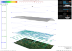
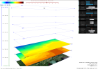
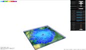
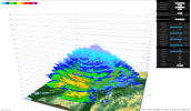
  • Sun angle and cloud edge height visualization
  • Wind, temperature, humidity, and gusts at adjustable altitudes (starting from 10m and above)
  • Multiple display modes (isolines, wind barbs, planes, etc.)
  • Interactive controls to navigate forecast times
  • And more
To make it publicly available, we’d like to gather feedback if some of you are interested in trying it out? It’s completely free, of course!
I’ve attached a few screenshots to give you an idea of how it works. If there’s enough interest, we’ll make the necessary adjustments for a wider release.
Let me know your thoughts.
 

Attachments

  • screenshot1.png
    screenshot1.png
    631.5 KB · Views: 11
  • screenshot2.png
    screenshot2.png
    500.1 KB · Views: 11
Any chance your app will incorporate single scan radar so storms can be tracked in real-time (within seconds as opposed to waiting 5 minutes for 3D radar)?

Will this be for iOS , Android, or both?

I would be glad to give it a chance on my iPhone XS.
 
Any chance your app will incorporate single scan radar so storms can be tracked in real-time (within seconds as opposed to waiting 5 minutes for 3D radar)?

Will this be for iOS , Android, or both?

I would be glad to give it a chance on my iPhone XS.
Our primary target is browsers. However, since our tool is web-based, it can also be easily accessed on mobile devices via mobile browsers.
As for native apps, we currently lack the human resources to develop them, as there are only two of us working on this.

Could you provide more details about the specific data and radars you're referring to? It would be helpful if you could share sample files containing the radar data.

You mentioned waiting about 5 minutes for 3D radar scans. Interestingly, another software project we’re developing involves processing and displaying 3D radar scans.
For radar data, we use Canadian sources from ECCC (Environment and Climate Change Canada). As you probably aware, they provide 17 radar scans every 6 minutes, covering elevation angles from 0.4° to 24.4°.
Our application processes and renders a web-based 3D model of all scans in just ~1 second. When accessed via a browser, it runs extremely fast—nearly real-time for a single scan.
I’ll attach a few screenshots for reference.
I’d like to share a demo HTML file containing the actual program you see in the screenshots with 17 radar scans for Blainville, Quebec, but the forum restricts file attachments due to size limits. If there’s another way to send it to you, let me know
 

Attachments

  • screenshot4.png
    screenshot4.png
    1 MB · Views: 3
  • screenshot3.png
    screenshot3.png
    1.8 MB · Views: 3
  • Like
Reactions: 1gratefulflyingdawg

DJI Drone Deals

New Threads

Members online

Forum statistics

Threads
137,546
Messages
1,628,433
Members
166,118
Latest member
Jiddles
Want to Remove this Ad? Simply login or create a free account