DJI Mavic, Air and Mini Drones
Friendly, Helpful & Knowledgeable Community
Join Us Now

When Mavic Pro is flying to a waypoint, how does it react to changing side winds ?

swb_mct

Well-Known Member
Joined
Apr 12, 2018
Messages
66
Reactions
21
Age
79
I need to know if the cameras forward view stays pointed in a specific direction when it has to compensate for changing side winds when it is on its way to a GPS waypoint.
In other words does it compensate for changing side winds exclusively with ROLE keeping the camera pointed at its target?

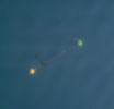
These are two buoys 8 feet feet below the surface of a lake, attached to a 4 foot horizontal spreader.

This image was from a flyover straight from my location over the location of buoys with 0 wind. I need to know if orientation of the buoys as it appears from the straight down view of the camera will be the same if the there is a slight west breeze or a slight east breeze ? I am hoping the cameras looks straight at it its GPS target and not YAW left and right with the breeze.

What's this about ? Its about a submersible Slalom Course. I am hoping this orientation of these buoys changes in the next 6 months. Without a boat between now and May 2022, the drone is my only way to inspect this pair of buoys 700 feet from shore.

These buoys are on a single rope that passes through a pulley 68 feet down. There is a twist in the rope and I need to get it untwisted. Its a puzzle because there is no way to know how to untwist it without diving and that's not easy to arrange. I am hoping the 4 foot spread at the top and 30 pounds of buoyancy will slowly unwind the twist over the next few months.
green-red.png
 
Last edited:
When the drone is over the target could you not centre a land mark in the screen then point the camera down. If there is no current then the buoys should be above the anchor and that would ensure the camera's heading was a constant.
 
  • Like
Reactions: swb_mct
When the drone is over the target could you not centre a land mark in the screen then point the camera down. If there is no current then the buoys should be above the anchor and that would ensure the camera's heading was a constant.

I don't understand your question . . not that sharp with drones. The buoys aren't a waypoint because I have no way to manually input the coordinates which I know. I am able to find them with the down facing camera when the drone is on a line of sight trajectory and I know 700 foot distance when I expect a siting.

If a drone is blown off its original course to a waypoint, does it go back to the original course, or just change its heading creating a new course to the target ?
 
Last edited:
If your drone is oriented properly (heading 0), located physically over the same geographic location (42.0000,-125.0000), and at the same elevation (100M), it should always capture the same area of water in the image. Except that, the GNSS error for the location will be large; the angle of the buoys will be the same (within the repeatability of the drone compass and your ability to control the drone heading), but the X,Y positions will change in the image due to the GNSS errors.

Here's my drone hovering inside my garage. It is not moving, yet, the GNSS coordinates are.
Capture.jpg

As sar104 said, the drone flies a true course. Sidewinds do not affect the line it draws over the ground (very much).

To test this yourself, fly the drone, push it out forward 200 yards in a crosswind, then pull it back 200 yards. How far is it from where you started?
 
If your drone is oriented properly (heading 0), located physically over the same geographic location (42.0000,-125.0000), and at the same elevation (100M), it should always capture the same area of water in the image. Except that, the GNSS error for the location will be large; the angle of the buoys will be the same (within the repeatability of the drone compass and your ability to control the drone heading), but the X,Y positions will change in the image due to the GNSS errors.

Here's my drone hovering inside my garage. It is not moving, yet, the GNSS coordinates are.
View attachment 136944

As sar104 said, the drone flies a true course. Sidewinds do not affect the line it draws over the ground (very much).

To test this yourself, fly the drone, push it out forward 200 yards in a crosswind, then pull it back 200 yards. How far is it from where you started?
When I manually fly the drone to a landmark in the lake and hover over it, I I think I am hearing you say there is a way to get the drone to record that location . . is that right ? And then have the drone fly to that landmark on another flight . . is that right. If that is true do the coordinates get saved somewhere for the next day etc. ?
 
When I manually fly the drone to a landmark in the lake and hover over it, I I think I am hearing you say there is a way to get the drone to record that location . . is that right ? And then have the drone fly to that landmark on another flight . . is that right. If that is true do the coordinates get saved somewhere for the next day etc. ?
Not what I am saying. There are apps for some drones that may help do this - Litchi is one; DroneDeploy another; and others.
 
  • Like
Reactions: swb_mct
Have a look in the special programs section (only available when linked to the MP1 ) of Go4 for waypoints. You can fly a route and record waypoints for the drone to visit repeatedly.
Syonyk’s blog has a complete rundown of all the MP1 Go4 settings that are missed in the pathetic but normally unread DJI manual. I think that the original blog may have gone missing but someone has archived it HERE.
 
  • Like
Reactions: eEridani
When I manually fly the drone to a landmark in the lake and hover over it, I I think I am hearing you say there is a way to get the drone to record that location . . is that right ? And then have the drone fly to that landmark on another flight . . is that right. If that is true do the coordinates get saved somewhere for the next day etc. ?
I think that you can record waypoints with the C1 and C2 buttons.
I have never done it that way but I think that it is possible on a Mavic pro. Search the web.
 
I don't understand your question . . not that sharp with drones. The buoys aren't a waypoint because I have no way to manually input the coordinates which I know. I am able to find them with the down facing camera when the drone is on a line of sight trajectory and I know 700 foot distance when I expect a siting.
OK, my understanding is that you take off, probably from one specific location, then fly out in a general direction to a set distance where you then look for the buoys by using the drone's camera and looking at the image seen on the screen of your 'phone'.
Taking that as correct the camera is pointed downward.
What I was suggesting is that once the drone is over the buoys, you tilt the camera upwards and, yawing the drone, you look for a landmark. Once you find a suitable landmark yaw the drone so that the landmark is in the centre of the phone's screen.
Assuming that the buoys do not drift much in any variable current then the above procedure has your drone hovering over a specific point with the camera facing in a specific direction. Tilt the camera down to verify the drone is still over the buoys, if not adjust the drone's position as needed, then recheck that the landmark is still centred in the phone's. Once you have confirmed that the drone is over the buoys and the camera is facing in a specific direction take a picture of the buoys. The specific direction serves as a basis against which you can compare the orientation of the buoys.

I would add to Sar104's post that lateral thrust means it adds sideways flight, into the wind, to fight the side wind.

With regards to your current manual flight out to the buoys, it is my experience that whilst I am making a drone climb or descend I often, inadverently, add yaw to the climb or descent. Even if you do not do that you would need to be careful to orientate the drone in a consistant direction prior to take off to ensure that you arrive over the buoys with the drone/camera on a consistant compass heading. This is one reason why I think making the camera face in a specific direction when the drone is over the buoys etc. is a better than simply relying on the drone/camera having a specific compass heading when you do get it over the drone.
 
Last edited by a moderator:
f a drone is blown off its original course to a waypoint, does it go back to the original course, or just change its heading creating a new course to the target ?
Unlike navigating in an airplane or crossing a stream the drone doesn't offset it's heading while correcting for a crosswind it banks therefore the longitudinal axis is always straight ahead. Very clever these drones!
 

DJI Drone Deals

New Threads

Forum statistics

Threads
134,484
Messages
1,595,517
Members
163,011
Latest member
Rckern85
Want to Remove this Ad? Simply login or create a free account