I just re-read what you wrote and I now see that you understand the 400' AGL rule… but I spent a lot of time drafting this up so I'm still posting the 400' stuff for others who do not understand…
But I am confused, I have read various accounts by other members recounting the altitude issues as you have mentioned that your maximum altitude is 500 meters but I always just figured that was self-imposed by them making that setting in the App.
But now that you mention it, I went to the
Mavic 3 Pro User Manual and it is pasted below and it indicates that you can fly way higher… So I do not understand… DJI says it's a lot more…
By the way, my
Mini 2 also has specs like this but I have never tried to fly that high…
View attachment 153356
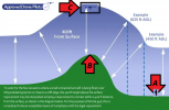
Be that as it may, here is a visual graph to indicate what you can do relative to flying over that hill… If you are standing at position "A" and that hill is "B" that is 1,241' high and you fly your drone over the hill to position "C", your drone would still be only 400' above ground level (AGL)…
View attachment 153357
If the FAA did not take land contours into consideration when they wrote the rules, then the folks who live in Denver, Colorado, could only fly their drones if someone dug a really deep hole 5,600' down…
You live in Alaska and if you took a "short" hike up Mount McKinley and it's what 20,000 some odd feet high… And you've packed your drone with you and you want to fly your drone up there ***
And with all the might that your little bird can muster, it manages to lift off and hover at face level so you can take a "selfie"… Even at this stratospheric altitude where the air is rarified, you are only about 5' AGL…
*** I know your drone cannot fly in such rarified air, heck, there's hardly enough air up there to breathe… I'm just using Mt. K. as an example of terrain…


