DJI Mavic, Air and Mini Drones
Friendly, Helpful & Knowledgeable Community
Join Us Now

DJI NFZ recently change? 2 Yrs now getting blocked

Dougcjohn

Well-Known Member
Joined
Nov 18, 2017
Messages
969
Reactions
527
Age
66
Has there been a recent update to Go4App or Aircraft that has changed the NFZ GeoZone and the behavior to acknowledge "restricted zones" ?

I've been flying a Downtown City Construction site for nearly 2 years. Always received an In-App popup warning about a Jail in the vicinity (8-10 blocks away) and I was able to touch a little radio button icon that acknowledged the warning & indicated I took responsibility. Done!

Today, I was prevented to fly due to Jail in vicinity. Got a similar looking DJI Popup Warning, but without any method to acknowledge and ability to accept. Message stated a Jail was in the vicinity and Jail was restricted and needed to use FLYSafe to apply. Went to FlySafe and that appears to have changed too... now it requests you upload "authorization letter head document" by the authority of the restriction. In my case, I need to obtain a letter of authorization from Jail Admin or City Police that indicates I'm authorized to fly.

As of 2 weeks ago, this didn't exist! I simply acknowledged the jail warning and continued with my flight plans.
A question in thought, I've ignored an in-app prompt to update the aircraft geozones that last several weeks. If this isn't updated, does a restriction preventing flight get applied?
I've not experienced that before, but I've not experienced a distant Jail preventing flight either.

Another irritant, the NFZ unlocking used be accessible via Cellular Phone. Now you get a message, Phone App not useable, need to use regular Browser.

Just curious if anyone has noticed a change in DJI NFZ GeoZone approvals.
 
Zones change all the time, and different types of zones allow for different unlock methods.

Seems they changed the type of the zone you're in to a more restrictive level.
 
Zones change all the time, and different types of zones allow for different unlock methods.

Seems they changed the type of the zone you're in to a more restrictive level.
actually not... still shows the exact same thing... a Jail in vicinity, which is 8 blocks away.
The various zones still look the same & same color. The Jail was always "red" but you could acknowledge and move forward. Jail still shows "red" but now states restricted and unable to unlock.
 
I've been getting the message "flysafe data update" (or something like that) and I plan to hit ignore until it won't let me ignore it any more.

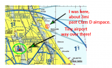
Just today I was doing a practice flight by Lake Michigan, far away from everything, and a NFZ warning popped up that I was "near" Chicago Executive Airport". As you can see from the sectional map I was nowhere near it, totally in Class G space. Yet, DJI in its infinite wisdom decided I needed a warning, even though my M2 would have a difficult time getting to the perimeter of Class D space and returning on one battery. At least I wasn't geofenced.

Without getting too far off the reservation, I think that the need for third party geofencing indicates the general condition of society today where a third party has to put up electronic fences and too many imbeciles are too willing to break the rules that actually protect life and property creating the need for geofencing (and other non-related and often non-effective laws) in the first place.

And as I've said here on the forum several times:
"Coffee leads to donuts, donuts leads to ants"... And the ants are on their way in 20 months with remote ID.

1609707351691.png
 
I submitted a request to FlySafe, they rejected but provided an email channel. I inquired as to the change and not able to fly. They responded “ request“ was rejected because I indicated altitude above the FAA Grid of 100 ft.

Hmm? I provided screen clips of the FAA LAANC Grid of 400 ft, my present & past LAANC authorizations for location. Again explained problem was Jail, not altitude within request. Received response my Request has been approved with instructions how to implement to both App and Aircraft... that’s gotten more drawn out too.

So I’m approved for the short period I requested, but unclear as to why the Jail status to self-authorize changed and why that wasn’t the focus of the approval... focus being altitude due to difference in FAA Altitude data.
 
@Dougcjohn

Pack the Mavic and bring out the H520 and the problem is solved. No more flight nanny. ?
Ya know it! DJI NFZ normally doesn't smack me this sort... if the H520 could comfortably give the range it'd be out there... this area of town with power substation across the street the 520 has it's own issues.

We need a combo of the two... Ocusync on a smooth flying 520 would be a hit!
 
  • Love
Reactions: DoomMeister
I had heard that some managed to self-unlock red restricted zones when the new flysafe method was implemented about 2 years ago, but that wasn't supposed to be possible. Only blue authorization zones were supposed to be able to be self-unlocked. I'm sure that was fixed soon after. 8 blocks is pretty close so there could be precision inaccuracies that you lucked out on until now. The warning could have been it considering you outside the zone, but making you aware that it is nearby so that you can avoid running into it.
Now it seems to think you're in the zone, not just near it.

Its hard to say without being there and seeing the actu outcome before and now.
 
I've been getting the message "flysafe data update" (or something like that) and I plan to hit ignore until it won't let me ignore it any more.

Just today I was doing a practice flight by Lake Michigan, far away from everything, and a NFZ warning popped up that I was "near" Chicago Executive Airport". As you can see from the sectional map I was nowhere near it, totally in Class G space. Yet, DJI in its infinite wisdom decided I needed a warning, even though my M2 would have a difficult time getting to the perimeter of Class D space and returning on one battery. At least I wasn't geofenced.

Without getting too far off the reservation, I think that the need for third party geofencing indicates the general condition of society today where a third party has to put up electronic fences and too many imbeciles are too willing to break the rules that actually protect life and property creating the need for geofencing (and other non-related and often non-effective laws) in the first place.

And as I've said here on the forum several times:
"Coffee leads to donuts, donuts leads to ants"... And the ants are on their way in 20 months with remote ID.

View attachment 120750
This is a different situation.
FAA does not consider the executive airport to be that tiny. It is a class D controlled airspace. I live in a similar airspace.

Comparing DJI's flysafe map for that area with what Airmap shows:

The spot you're flying in just along the shore is outside the airspace but that spot you point to is along a runway approach. From what I see in Flysafe map, DJI extended the runway approach as an altitude zone, limiting you to 400ft. Actually 150m

As you get closer and are near rt 43, the altitude is down to 60m. It shouldn't really be that low as facilities map shows 400ft over there. The adjacent squares in line between botanical and airspace center goes 300, 200 then zero. Pretty steep drop, but it does look like DJI may have overextended the altitude zone. They may have a set template for runway approaches at regional airports that might not accurately fit FAA's map.

Nearby O'Hare airspace doesn't help matters even if it's airspace is to the south of what you're concerned about.

I would contact DJI [email protected] and explain the problem.
 
I had heard that some managed to self-unlock red restricted zones when the new flysafe method was implemented about 2 years ago, but that wasn't supposed to be possible. Only blue authorization zones were supposed to be able to be self-unlocked. I'm sure that was fixed soon after. 8 blocks is pretty close so there could be precision inaccuracies that you lucked out on until now. The warning could have been it considering you outside the zone, but making you aware that it is nearby so that you can avoid running into it.
Now it seems to think you're in the zone, not just near it.

Its hard to say without being there and seeing the actu outcome before and now.
Getting zone reconized would be acceptable, but as indicated... the request was rejected and later approved based on Altitude... no mention of Jail. The Altitude would have been limiting but able to take off. This was just odd... approval should have been for Jail, which it wasn't... that's the odd part. That all said, I personally think a small jail shouldn't be a restricted zone like the Prison 4-5 miles away.


Similar to a Elec Substation... it's across the street as sited as aware, not treated the same as a full power station.

Going forward, my request to unlock is viewed for Altitude. It appears that DJI isn't aware the onscreen self approve hasn't changed. Made 3 attempts to clarify Jail block, and they only understood Altitude.
 
Try No Limit Dronez
I will be... but wasn't mentioning since it's frowned upon within the forums.
It's fully available for Inspire 2, but it's not for several of the last FW versions with Mavic 2 series platforms.
Actually, for M2P/E platforms it's not very useful and rather limited.
It's good for the M1 series though.
 
Getting zone reconized would be acceptable, but as indicated... the request was rejected and later approved based on Altitude... no mention of Jail. The Altitude would have been limiting but able to take off. This was just odd... approval should have been for Jail, which it wasn't... that's the odd part. That all said, I personally think a small jail shouldn't be a restricted zone like the Prison 4-5 miles away.


Similar to a Elec Substation... it's across the street as sited as aware, not treated the same as a full power station.

Going forward, my request to unlock is viewed for Altitude. It appears that DJI isn't aware the onscreen self approve hasn't changed. Made 3 attempts to clarify Jail block, and they only understood Altitude.
I often get class D warnings at a park, and I'm a couple miles from the class D airspace border when at the park. I just realized the park is in a yellow warning (not enhanced) zone as part of extension of runway approach.
 
Getting zone reconized would be acceptable, but as indicated... the request was rejected and later approved based on Altitude... no mention of Jail. The Altitude would have been limiting but able to take off. This was just odd... approval should have been for Jail, which it wasn't... that's the odd part. That all said, I personally think a small jail shouldn't be a restricted zone like the Prison 4-5 miles away.


Similar to a Elec Substation... it's across the street as sited as aware, not treated the same as a full power station.

Going forward, my request to unlock is viewed for Altitude. It appears that DJI isn't aware the onscreen self approve hasn't changed. Made 3 attempts to clarify Jail block, and they only understood Altitude.
Like I said, can't say much more without examining the location specifics in Flysafe map. Zone overlap can be a pain though.

Definitely jail should be blocked. Drones can be used to smuggle contraband. Being 8 blocks away should be far enough to not get a false trigger, but if you were a block away, I could see the fluctuation.
Whowever you were talking to wasn't looking very carefully. Probably didn't zoom in enough.
I could tell from writing, there was a little language barrier too. Although, I stipulated Jail restriction... the Altitude has zero bearing to prevent a take-off. He used my LAANC indicated coordinates to locate the request.
I think he misunderstood out the gate and got it in his head I was wanting more Altitude.

The DJI zone color is odd... within DJI even the power substation is indicated as Red but doesn't even present a self-authorization prompt. But on other charts neither are red or indicated as a restriction. 2 Hospital 4 blocks away, 3 Heli ports, 2 blocks away from Police HQ, and 3 blocks from Federal US Marshal Jail not showing up on any as a concern.
 
The problem with the geozones implemented by DJI is that they do not correlate with regulations in the USA. They do match more closely with the rules in Europe with the runway extensions. The programmers write to the more restrictive regulations and implement it for all areas
 
  • Like
Reactions: Dougcjohn
I could tell from writing, there was a little language barrier too. Although, I stipulated Jail restriction... the Altitude has zero bearing to prevent a take-off. He used my LAANC indicated coordinates to locate the request.
I think he misunderstood out the gate and got it in his head I was wanting more Altitude.

The DJI zone color is odd... within DJI even the power substation is indicated as Red but doesn't even present a self-authorization prompt. But on other charts neither are red or indicated as a restriction. 2 Hospital 4 blocks away, 3 Heli ports, 2 blocks away from Police HQ, and 3 blocks from Federal US Marshal Jail not showing up on any as a concern.
Red restricted zones aren't supposed to be self-unlockable.
DJI never restricted hospitals and the like but might zone them as warning zones.
The US Marshall jail should be restricted.

But like I said before twice, it would be hard for me to analyze without seeing the location.
 
  • Haha
Reactions: Ex Coelis
The problem with the geozones implemented by DJI is that they do not correlate with regulations in the USA. They do match more closely with the rules in Europe with the runway extensions. The programmers write to the more restrictive regulations and implement it for all areas
Just because it's legal to fly somewhere doesn't mean it's safe. Even runways at smaller airports in G space can be risky so DJI adds safeguards so you check twice.
Only the altitude restrictions lately seem to overextend.
 
Red restricted zones aren't supposed to be self-unlockable.
DJI never restricted hospitals and the like but might zone them as warning zones.
The US Marshall jail should be restricted.

But like I said before twice, it would be hard for me to analyze without seeing the location.
DJI has issues with their app regarding their zone, apparent in multiple situations. Their position in my opinion shouldn't be as a final authority to impose a restrictive block. They're not a regutory body, and haven't requested by a regutory body, it's been more self imposed more as a legal defense. That should be out of their scope of control... at most they should attempt to provide informational warnings that are acknowledged releasing DJI from legal actions. That "was" the original intention of their acknowledged zones. Furthermore, if they're wanting to attempt this level of zone control with a method to request unlocks, then they need to be much more accurate and staff with individuals that can communicate clearly and understand requests to accomplish the task promptly.

Many situations this self imposed oversight has created more grief or frustration completing a project ranging from SAR, FEMA, and sUAV businesses.

Yes, you've mentioned "three" times now you'd need more on-site information... that isn't necessary nor requested... I was focusing the question inquiring if others have recently experienced similar change in DJI app behavior.

I'm very capable to assess my area, overlaps or various zones. Regarding Jails, not all jails are a potential threat to aerial delivered contraband. Many jail yards, particularly within cities aren't open on ground like a court yard. Most have modified the "yard" for multiple reasons (not motivated by drone) to have 100% closed barriers. Normally City Jails have yard on upper floors with enclosed ceilings providing openings too small to throw, or drop contraband.

I can understand a Prison, where there are large courtyards located behind multiple parameter barriers. Although even some prisons have installed upper barriers... that was motivated by drone as one of the variables.

I also disagree that a jail 8-10 blocks away through multiple tall building requiring FPV flight through multiple RF Interferences is a grave concern. It is a concern and should be noted as aware, but not a high concern. That in itself is indicating the inaccuracies and need for more precise data before a stop action block is enacted.

DJI zone colors is their own design, and that should be modified. Again, their primary motivation is legal protection of their Company, that can be accomplished without a hard no take-off block that provides "minimal information" and poor methodology to resolve. Again, they aren't the regutory decision.. that is handled by others.

If that was a strong regutory concern, it'd first need to have high frequency to escalate, which it doesn't at all; and all manufacturers of sUAV would be requested to install controls... specified by the regutory bodies.

Point of thread was the frustration of app changes and also lack of upstream department to be aware and part of the app changes and to address the changes.
 
Last edited:
To bring humor to this ridiculous restriction of Jail.
I had appt today with Law Enforcement to obtain a letter head document to authorize my sUAV flights downtown for a period of 1 year intervals.

He shared that the Jail was closed, gutted and rebuilt about 3 years ago, and a YMCA structure occupies the land.

So No Jail in the area, the Jails were combined & moved outside City limits about 4 years ago.
No Jail, so DJI's map & zone location is behind 3-4 years for this particular zone.
 
Lycus Tech Mavic Air 3 Case

DJI Drone Deals

New Threads

Forum statistics

Threads
130,586
Messages
1,554,112
Members
159,586
Latest member
DoubleBarS