DJI Mavic, Air and Mini Drones
Friendly, Helpful & Knowledgeable Community
Join Us Now

Drone crash

cjungblom

Member
Joined
Jan 9, 2023
Messages
10
Reactions
3
Age
28
Location
Charleston, SC, USA
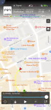
Hello all! 2 days ago I crashed my drone. Long story. Anyways I can’t find the dang thing. In my flight log it shows the yellow flight path and then shows where the path stops and the drone continues. Why did the yellow stop? Is it estimating where it landed? How accurate is this? It even shows directionally where it was facing

Also how can I download my flight log? When I export to csv it says successful and then even tells me where on the iPhone it saved it. I can’t find the dang thing to get it to my computer. Please don’t tell me iTunes… it’s 2022–how can I get my flight log?

It was a Mavic 2 pro


figured out flight plan. DJI Flight Log Viewer - PhantomHelp.com
 

Attachments

  • 325DAB6E-B1EA-42CE-AED0-BC8E53D4653F.png
    325DAB6E-B1EA-42CE-AED0-BC8E53D4653F.png
    2.5 MB · Views: 47
Last edited:
DJI Flight Log Viewer | Phantom Help

  • Post your flight data to get help
  • Go to DJI Flight Log Viewer | Phantom Help
  • Follow the instructions there to upload your flight record from your phone or tablet.
  • That will give you a detailed report on the flight data.
  • Come back and post a link to the report it provides.
You are also welcome to just post the txt file here.

Upload and view DJI Phantom, Mavic, and Spark flight logs online

@Meta4 is great at offering explanations from the data.
 
  • Like
Reactions: Drone Master
DJI Flight Log Viewer | Phantom Help

  • Post your flight data to get help
  • Go to DJI Flight Log Viewer | Phantom Help
  • Follow the instructions there to upload your flight record from your phone or tablet.
  • That will give you a detailed report on the flight data.
  • Come back and post a link to the report it provides.
You are also welcome to just post the txt file here.

Upload and view DJI Phantom, Mavic, and Spark flight logs online

@Meta4 is great at offering explanations from the data.
I figured it out. It’s at the end of my post!
 
Also can someone help me out w the settings. Like what did I do wrong here? The thing was going and then took off upwards vertically and then just like did a loop and crashed. Wtf?
 
Hello all! 2 days ago I crashed my drone. Long story. Anyways I can’t find the dang thing. In my flight log it shows the yellow flight path and then shows where the path stops and the drone continues. Why did the yellow stop? Is it estimating where it landed? How accurate is this? It even shows directionally where it was facing

Also how can I download my flight log? When I export to csv it says successful and then even tells me where on the iPhone it saved it. I can’t find the dang thing to get it to my computer. Please don’t tell me iTunes… it’s 2022–how can I get my flight log?

It was a Mavic 2 pro


figured out flight plan. DJI Flight Log Viewer - PhantomHelp.com
You didn't wait to get GPS reception before flying away from the home point.
Perhaps the the skyview at the starting location was blocked?
Flying without GPS limited your height to 5 metres and prevents climbing higher.
It also means that your drone was flying without horizontal position holding.

You didn't get good GPS reception until 1:27 and the drone was finally able to record a homepoint where the drone was at that time ... not where you launched from.

But there was a bigger problem as well.
You must have launched from a site where magnetic interference caused a yaw error.
When the drone finally got GPS reception, this started to act and fly the drone on an accelerating curved flight path, without you touching the right stick.

The conflicting data form compass and GPS caused by the yaw error meant that the drone was not able to hold position and as it detected motion, each attempt to correct flew the drone further and faster on a smooth curved flightpath.

Do you remember what direction the drone was pointing at takeoff?
The data shows that it was facing northwest (317°), but this will be wrong.
What was the surface you launched from?

When signal was lost the drone was in high speed curved flight and out of your control which is typical in a yaw error.
You had climbed to 170 ft higher than the launch point.
When the data ends the drone was still flying and had not crashed.
It had plenty of battery and would have kept flying until the battery reached critical low voltage level.
It is not possible to tell where it ended up.
 
Also can someone help me out w the settings. Like what did I do wrong here?
The main problem was that you launched from an area where magnetic interference caused teh compass to give incorrect data at startup.
That incorrect directional data was used to initialise the gyro sensors.
Launching and flying some distance without GPS might have caused issues too, but as it turns out the yaw error was a much bigger problem.

The thing was going and then took off upwards vertically and then just like did a loop and crashed. Wtf?
The data does not show any evidence of a crash.
The drone climbed because you pushed the right stick full forward and held it there.
 
If it looped a prop broke or came undone
Losing a prop does not cause the kind of flight shown in this incident.
With only 3 propellers, the drone can only spiral down into the ground.
 
You didn't wait to get GPS reception before flying away from the home point.
Perhaps the the skyview at the starting location was blocked?
Flying without GPS limited your height to 5 metres and prevents climbing higher.
It also means that your drone was flying without horizontal position holding.

You didn't get good GPS reception until 1:27 and the drone was finally able to record a homepoint where the drone was at that time ... not where you launched from.

But there was a bigger problem as well.
You must have launched from a site where magnetic interference caused a yaw error.
When the drone finally got GPS reception, this started to act and fly the drone on an accelerating curved flight path, without you touching the right stick.

The conflicting data form compass and GPS caused by the yaw error meant that the drone was not able to hold position and as it detected motion, each attempt to correct flew the drone further and faster on a smooth curved flightpath.

Do you remember what direction the drone was pointing at takeoff?
The data shows that it was facing northwest (317°), but this will be wrong.
What was the surface you launched from?

When signal was lost the drone was in high speed curved flight and out of your control which is typical in a yaw error.
You had climbed to 170 ft higher than the launch point.
When the data ends the drone was still flying and had not crashed.
It had plenty of battery and would have kept flying until the battery reached critical low voltage level.
It is not possible to tell where it ended up.
Well ****. Thank you very insightful. I launched off a sidewalk.
I’m assuming DJI will tell me to shove it as it’s mostly my fault.
 
I want to get another one but honestly I’m struggling to find the use. This was just a hobby for me and you can’t fly them in most cities, can’t fly them at national parks, can’t fly them within like 15 miles of an airport. I mean where the hell am I supposed to take this thing lol?
 
  • Like
Reactions: djwak59
Well ****. Thank you very insightful. I launched off a sidewalk.
I’m assuming DJI will tell me to shove it as it’s mostly my fault.
Launching from reinforced concrete surfaces can cause a yaw error.
In the past DJI would have said it was your fault, but recently thay haven't been very good at flight analysis and quite a few people have had warranty replacements when the data showed similar things to what yours does.
Try a claim and you might be lucky.
 
  • Like
Reactions: SeaPig
Launching from reinforced concrete surfaces can cause a yaw error.
In the past DJI would have said it was your fault, but recently thay haven't been very good at flight analysis and quite a few people have had warranty replacements when the data showed similar things to what yours does.
Try a claim and you might be lucky.
Dang. I will try. I’m assuming a claim is only good for a certain time frame by original owner
 
will it have continued to fly in an arc of that radius?
I am just wondering if it would have orbited until battery exhaustion?
Possibly, but under the circumstances it's hard to be certain.
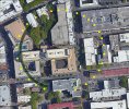
If it stayed on the same path, the drone (or wreck) would be somewhere here.

cp.jpg
 
Possibly, but under the circumstances it's hard to be certain.
If it stayed on the same path, the drone (or wreck) would be somewhere here.

View attachment 159274
Yeah :( I went around and looked a few hours but roof access is nearly impossible. If it hit the street someone took off w it I’m guessing. Either that or it’s in a tree somewhere. Tragic

Thanks for your time on this
 
Lycus Tech Mavic Air 3 Case

DJI Drone Deals

Forum statistics

Threads
130,591
Messages
1,554,152
Members
159,592
Latest member
BHU