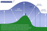
I just wanted to check the right way to achieve this. I am doing a flight from a starting height of 55m (we are in the foothills of North Wales) and opposite is a smallish mountain that tops out around 100m or so.
With the flying guidance that you can fly 120M above the ground, once i crest that hill i should be able to ascend to 220m (based on 120m) above ground rather than sea level.
The app caps my height at 120m above sea level, and i'm not sure what the correct thing to do is here to allow the drone to ascend to the full height? Currently annoying sheep if i go futher at daisy cutting height so i turn around, and with the undulations around here i will often be flying low to high. Any suggestions appreciated. Link to video below so you can see the terrain..
Flight up the hill


