- Joined
- Mar 4, 2017
- Messages
- 19
- Reactions
- 5
- Age
- 71
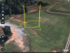
Google has finally released last week a major update to Google Earth so it runs in the iPad. If you currently upload your flights AirData (HealthyDrones) then it very simple to get a great 3D map of any of your flights. I’ve created a simple video to outline the steps below.