DJI Mavic, Air and Mini Drones
Friendly, Helpful & Knowledgeable Community
Join Us Now

Help! My Mavic Mini is like Rhett Butler: Gone With the Wind

If it made any progress it would have been single digit mph. More likely it went into fight the wind mode, and lost the battle until the battery died.

I'd start looking for the drone where the signal was lost, then trend downwind. I wouldn't expect it to be too far away.

View attachment 142742
Those Airdata wind calculations are known to be wrong when dealing with a Mini that suffers from flattened props which can't create enough thrust to pitch the craft according to spec ...

The Mini should be able to reach a tilt angle in P-mode (which RTH uses) of 20 degrees ... here we see an average of 10 degrees.

So the wind wasn't at all that strong as Airdata indicate ... but this condition with bad thrust creating props makes the Mini very prone to "Blow away" even it light winds ... which happened here.

Red = tilt angle & green = elevator stick (value 1024 equals neutral), pink area ongoing RTH that pushes towards the HP with P-mode specs.
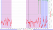
1643237291224.png

...I found my drone safely nestled in the tall grass. Not even a hard landing!


View attachment 142740

View attachment 142741
The actual location was just beyond the projected drop zone, which could have easily been pushed by the wind gusts.
Wow ... great, & thank's for reporting the actual location, good to validate the calculations from time to time Thumbswayup 😁

Now ... change all those 4 props with a couple pairs of new ones.
 
  • Love
Reactions: Daddystu
@slup: Yeah - bad props are problems, but local weather reported 20 mph winds, gusts to 26. So the AirData estimates aren't that far off what the locals reported.

I'm curious what the drone heading was when the signal was lost. Was it pointed southward in the direction of drift or northward?

@Daddystu: Congrats on the recovery. My apology for the knee jerk initial reaction of "You ignored the warnings?"
 
  • Like
Reactions: Daddystu
Those Airdata wind calculations are known to be wrong when dealing with a Mini that suffers from flattened props which can't create enough thrust to pitch the craft according to spec ...

The Mini should be able to reach a tilt angle in P-mode (which RTH uses) of 20 degrees ... here we see an average of 10 degrees.

So the wind wasn't at all that strong as Airdata indicate ... but this condition with bad thrust creating props makes the Mini very prone to "Blow away" even it light winds ... which happened here.

Red = tilt angle & green = elevator stick (value 1024 equals neutral), pink area ongoing RTH that pushes towards the HP with P-mode specs.

View attachment 142744


Wow ... great, & thank's for reporting the actual location, good to validate the calculations from time to time Thumbswayup 😁

Now ... change all those 4 props with a couple pairs of new ones.
Right away, sir! BTW I have a lot of ancestors from the Dalarna region, so we're probably related somehow, ha ha. Thanks, Cuz!
 
All hail, King Slup! With his expert analysis (and a lot of luck, for sure), after a couple hours of searching outward from the first circle, I found my drone safely nestled in the tall grass. Not even a hard landing!


View attachment 142740

View attachment 142741
The actual location was just beyond the projected drop zone, which could have easily been pushed by the wind gusts.

This was over 1,500 ft from its last known position.


I haven't fired it up yet, but everything seems to be in order, but I might need to replace some props.

Thanks to everyone for your support!

Well congrats !!
That has to be up there with the best of the Crash analysis results on here, and there are some great ones.
Awesome work @slup

That has to be about the best landing place you could have wished for, up high and visible, soft-ish landing, really a gift of a 2nd life for that Mini.

Do watch the wind in particular in future, and try keeping it a bit more in VLOS, you should not have to go through this again.
Cheers.
 
@slup: Yeah - bad props are problems, but local weather reported 20 mph winds, gusts to 26. So the AirData estimates aren't that far off what the locals reported.

I'm curious what the drone heading was when the signal was lost. Was it pointed southward in the direction of drift or northward?

@Daddystu: Congrats on the recovery. My apology for the knee jerk initial reaction of "You ignored the warnings?"
No worries, eEridani. You were right, I did ignore the warnings!
 
All hail, King Slup! With his expert analysis (and a lot of luck, for sure), after a couple hours of searching outward from the first circle, I found my drone safely nestled in the tall grass. Not even a hard landing!


View attachment 142740

View attachment 142741
The actual location was just beyond the projected drop zone, which could have easily been pushed by the wind gusts.

This was over 1,500 ft from its last known position.
View attachment 142743

I haven't fired it up yet, but everything seems to be in order, but I might need to replace some props.

Thanks to everyone for your support!
Excellent. You are a very lucky guy. Bet your heart leapt when you found it. Your drone wanted to be home with its owner. Next job, mark with your phone number and email on the chassis and in a file on the mem card. I also attached a Bluetooth "tile" to mine to help with finding when the battery dies, but this has its pros and cons. Personal choice but this helped me a couple of times when I first started in this hobby. Have since removed it as, having moved up to the bigger drones, I leave the mini at home on everything but the calm days.

Live, learn and fly
 
Last edited:
  • Like
Reactions: Daddystu
...BTW I have a lot of ancestors from the Dalarna region, so we're probably related somehow, ha ha. Thanks, Cuz!
😁 Probably ... I'm living in the region called "Närke" just south of Dalarna.

...but local weather reported 20 mph winds, gusts to 26
Local weather reports are rarely usable for this kind of investigations.

I'm curious what the drone heading was when the signal was lost. Was it pointed southward in the direction of drift or northward?
Oh ... I thought you had looked into the log ... it was pointing towards the HP most of the later flight & so also when it lost connection.
 
😁 Probably ... I'm living in the region called "Närke" just south of Dalarna.


Local weather reports are rarely usable for this kind of investigations.


Oh ... I thought you had looked into the log ... it was pointing towards the HP most of the later flight & so also when it lost connection.
Regarding that, is there a way to see the heading while I am using the DJI app if I have lost the connection? Someone mentioned in another thread rotating their drone 180 degrees, but I can only do that if the video is connected. I was using the sticks trying to move it closer to home to re-establish the RC connection, but I have to do it by watching for the distance from home reading to decrease. Sometimes I am pushing it farther away by doing that.
 
...is there a way to see the heading while I am using the DJI app if I have lost the connection?
If you by "losing connection" means that you just have lost the live view but still have control signal connection with your drone ... then the answer is yes. You have the map view in the app, bring that up and you will see that your drone icon there is always attached to the HP by a line. So if you lose just the camera live view you can on the map turn the drone icon, line it up with the line that goes to the HP & apply stick for forward speed. Or ... you could initiate RTH manually from the RC.

If you instead mean a completely loss of RC-drone connection (both control signal & live view) ... then the answer is no, your drone is on it's own & in the hands of the failsafe action you have set in your app earlier when you lastly had the drone connected.
 
  • Like
Reactions: Daddystu

DJI Drone Deals

New Threads

Forum statistics

Threads
130,593
Messages
1,554,197
Members
159,598
Latest member
fast54