DJI Mavic, Air and Mini Drones
Friendly, Helpful & Knowledgeable Community
Join Us Now

High Altitude Flying. Anyone else flying higher than this? Notes and thoughts. Yours?

KI5RLL

Well-Known Member
Joined
Oct 10, 2022
Messages
200
Reactions
166
Location
Fort Worth, TX, USA
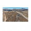
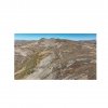
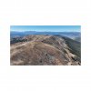
I did several flights between 13000 and 14000ft MSL.

DJI specs the Mavic 3 max service ceiling at 5KM (16,000ft) MSL. The Mavic Air 2 also. Maybe more of their series too.

It flew great! No motor rpm warnings or other warnings. It flew fine and climbed right up a 45° mountainside easily. Cruised at 33 mph across the peak ridge no problem. It did not sound like the motors were screaming max rpm.

DJI also flew the Mavic 3 well above the peak of Mt. Everest which is over 29000 ft. They posted great pics and vids of it.

I plan to go up to 14-15000 MSL and try it again.
I was above the vegetation line so it felt moonscape weird where no human items or frame of references were there. I posted several of the videos on YouTube yes.

How did yours handle at high altitude?

You think DJI maybe used hi-pitch props for the thin air over Everest?

Does DJI think 5KM MSL is where it can’t get lift anymore, without hi-pitch props? Mine was doing great.
Anyone else flying higher with the Air 2 or Mavic 3?
 
Yea I never notice much difference flying in the mountains either.

Max service ceiling generally refers to the maximum altitude at which the aircraft can continue to climb at a certain speed. Since DJI doesn’t define what that speed is it’s very ambiguous. It certainly doesn’t mean the altitude at which it can no longer operate.

I always took it as maximum altitude at which the aircraft can continuously climb at top vertical speed and top horizontal speed simultaneously in sport mode but who knows.

If you full throttle up and forward at 16,000 feet I would expect you might get a max motor speed or max amp draw warning before long but there are very few places in the US you can legally test that out (all in Alaska as far as I know)

As far as I could tell they were using stock props in that Everest video. The MAS props have a higher prop pitch and can effectively be used as high altitude props.
 
Contact DJI support they were flying at 30000 ft over Everest possibly you can get some insite from there experience in 1/4 density air.
 
I flew my Mavic Pro1 twice at high altitude, at the border between Argentina and Chile, using its standards propellers and batteries. Location: Mina Julia, Puna Argentina, Salta Province, Argentina (25°05'55.81 S, 68°21'23.59 W and 25° 01' 57.60" S, 68° 13' 02.33" W)
I went there first in January 2018 flying it at 5,500m (18,333ft) starting from 5,225m (17,416ft), visible here:


and then again in January 2020 flying it at 5,674m (18,913ft) also starting from 5,225m (17,416ft), visible here:


I put on YT a short video resuming the problems I had in 2020: loss of focus in Autofocus mode and sudden rotations of the drone out of control, but maintaining quote and position. They are visible here:


I also had a Motor's Max Speed warning a couple of times at the highest altitude, certainly due to thin air: I also had difficulties breathing up there!

A part these problems, the drone came home both times safely. Yes, don't tell me, I know: I've been lucky, both times.
I wish I could test there my Mavic Pro2 now, to see the difference and enjoy Hasselblad's superior images...
 
Last edited:
BigBoozer I am jealous!
That was some awesome flying and experiences. Well done and thank you for the insight, videos, and thoughts.
 
I fly at 12,000 to 14,000 feet quite often around Breckenridge. I like to fly over Quandary Peak, Quandary Peak is the highest summit of the Tenmile Range in the Rocky Mountains of North America and tops out at 14,271. I look for mountain goats and evidence left from old mines. I am blown away that humans built structures that high and on such steep cliffs. My Air2 has never had a problem at altitude unless major wind comes up.DJI_0066.JPG
 
You have access to an incredible area for flying. I think I could spend a liftetime just flying The Rockies. I was over Eisenhower pass flying above the I-70 tunnel last time.
Yes I am always searching for anything manmade up there above the vegetation line. Is a beautiful kind of stark moonscape.
Out west in the deserts I look for ancient settlements and archaeological areas and mines and such also.

Safe flying,
KI5RLL
 
I fly at 12,000 to 14,000 feet quite often around Breckenridge. I like to fly over Quandary Peak, Quandary Peak is the highest summit of the Tenmile Range in the Rocky Mountains of North America and tops out at 14,271. I look for mountain goats and evidence left from old mines. I am blown away that humans built structures that high and on such steep cliffs. My Air2 has never had a problem at altitude unless major wind comes up.View attachment 156122
Makes me homesick for Colorado - Spent my 1st 42 years there. :)
 
  • Like
Reactions: KI5RLL
How did you guys all get permission to exceed the 120 metres height limits, and the LOS regulations, which the moderators on here assure me that most of we drone owners do actually get, and very few of us fly illegally. I would be very interested, because I fly illegally regularly, and we like to keep the moderators happy, who believe that people like me are endangering the free use of drones .....
 
How did you guys all get permission to exceed the 120 metres height limits, and the LOS regulations, which the moderators on here assure me that most of we drone owners do actually get, and very few of us fly illegally. I would be very interested, because I fly illegally regularly, and we like to keep the moderators happy, who believe that people like me are endangering the free use of drones .....
Flying at about 13,000 MSL here (pics below) as I explained when I started this thread. So just how high above ground do you think it is?
 

Attachments

  • 7313D13D-D1E3-41B2-BE62-92B8CE78055E.jpeg
    7313D13D-D1E3-41B2-BE62-92B8CE78055E.jpeg
    277.8 KB · Views: 18
  • 0CC16B64-81FE-445A-9457-B5C9D22B6A59.jpeg
    0CC16B64-81FE-445A-9457-B5C9D22B6A59.jpeg
    277.7 KB · Views: 17
  • 273D821B-D878-469D-986C-B8714EB190EA.jpeg
    273D821B-D878-469D-986C-B8714EB190EA.jpeg
    240.7 KB · Views: 16
  • B0A9BAA2-3952-4641-923C-F6EEC2209A58.jpeg
    B0A9BAA2-3952-4641-923C-F6EEC2209A58.jpeg
    242.6 KB · Views: 18
How did you guys all get permission to exceed the 120 metres height limits, and the LOS regulations, which the moderators on here assure me that most of we drone owners do actually get, and very few of us fly illegally. I would be very interested, because I fly illegally regularly, and we like to keep the moderators happy, who believe that people like me are endangering the free use of drones .....
How far above ground (feet or meters either one) do you think brouigu1 is flying in his picture above in the US State of Colorado?
 
I dunno, could only guess, but you did state that you flew up a 45 degree slope easily, then flew over a peak, so the assumption I made was that you were above 140m and beyond LOS. If I have misinterpreted your post, plase forgive me ...
 
@Suzygs1000 AMSL is the key here.
Fine and legal to fly up a slope to whatever altitude you like too, as long as you keep the drone within the 120m / 400’.
Like you could fly up Bartle Frere, or Bellenden Kerr and keep your drone within 120m AGL, and legally if your eyes are really good 😉
Keeping to VLOS is another matter, and like you probably most pilots do break this one occasionally.
 
I dunno, could only guess, but you did state that you flew up a 45 degree slope easily, then flew over a peak, so the assumption I made was that you were above 140m and beyond LOS. If I have misinterpreted your post, plase forgive me ...
MSL = mean sea level. In some of the places mentioned above, they could still be only 200 feet above ground level, but still well past the rated ceiling.

What they're discussing is that at certain altitudes it becones a challenge to create and maintain lift, the air density drops and higher prop speeds are required to prevent stalling. That can further become more challenging once you start trying to bank and move, can potentially start losing altitude as you try to get from point a to b because there's not enough speed or power to maintain both lift and thrust with such low density air.

And while vlos is a must in the US and most places, it's not expected that you'll be staring at your drone the whole time as you would be looking at your screen as well as regularly scanning the area for manned aircrafts and other potential problems. At least they're flying areas of congestion with plenty of potential harm to people or property.
 
Ok, I get that ... bit of a loop hole, isn't it? I'm not far of 80, and I can't see mine when it's 50metres away .... but I generally fly over a lot of bushland or canefields, so even tho illegal, pretty safe .... but thanks for the info .... Dave

(60 metres up, and about 50 metres away from home)
 

Attachments

  • DJI_0010.JPG
    DJI_0010.JPG
    4 MB · Views: 7
  • Like
Reactions: MAvic_South_Oz
Ok, I get that ... bit of a loop hole, isn't it? I'm not far of 80, and I can't see mine when it's 50metres away .... but I generally fly over a lot of bushland or canefields, so even tho illegal, pretty safe .... but thanks for the info .... Dave

(60 metres up, and about 50 metres away from home)
Varies from person to person I'm sure and not like you're constantly looking at it. Can be easy to lose if you look away.

Personally on a good weather day I find that at 300 feet up or so, my visual limit of seeing where my drone is, is about 1000 feet or so. Less if I'm flying the smaller mini 2 with just it's standard gray color. But even tho I can see it, doesn't necessarily mean I can visually determine its orientation or precise proximity to other objects.

The real question is, if you do lose sight of your drone, do you have a plan in place on what to do from there? If not then that's worse than just losing vlos.
 
  • Like
Reactions: lorpal
I dunno, could only guess, but you did state that you flew up a 45 degree slope easily, then flew over a peak, so the assumption I made was that you were above 140m and beyond LOS. If I have misinterpreted your post, plase forgive me ...
MSL: Mean Sea Level. AGL: Above Ground Level.
In the US the legal max altitude is 400ft AGL (120 meters) considered to be the pilot standing where the craft took off. But as I flew up the side of mountain from where I was parked staying about 30ft from rocks, I am still 30ft above ground level (AGL). I climbed LOS a couple hundred feet to the top/ridge/edge. Straight right there in clear air. Still 30-60ft AGL. Still visible up in front of me. AGL legal ✅, LOS legal ✅.
My takeoff point was around 13000ft MSL. Above seal level. I was parked at Eisenhower Pass on the vehicle highway on the mountain. High altitude flying. So I gained a couple hundred feet above there, staying 30-60ft above dirt and rocks. Well in theory, I could have kept climbing higher still, as long as within LOS. But I already reached the peak there. So I kept low because of the thin air.
Land altitude varies unless you are really in a flat country or area (Australia example.)
Across the US you can drive from sea level to near 14000ft (State of Colorado, Rocky Mountains) and walk or hike higher, drone in your hand. Several states are over 7000ft also. Drive up to where you park. Then fly from there. High altitude flying.
BUT:
If I fly from where I am parked straight out over the downslope of the mountain, I can be way over 400ft AGL pretty quickly. Could be a couple thousand feet AGL quickly in many areas. Though only 5 feet above takeoff point. So then that is far above 400ft AGL and ❌ Not legal then. Even if close near me and easy LOS. Craft could be 2000ft AGL but only 300ft from me standing on dirt. Straight over the edge.
Yes I may be well below in a valley with peaks on either side, but AGL is AGL.
So we stay under 400ft above dirt. Where we can see our craft. We are just doing it on a mountain.

Is this the explanation you are asking about?

Safe flying,
KI5RLL
 
How far above ground (feet or meters either one) do you think brouigu1 is flying in his picture above in the US State of Colorado?
I am physically up at that altitude, my drone does not go above the 400 foot limit so I stay legal. VLOS is another question entirely mainly due to colors matching the ground. While I do maintain a visual on my drone there are times, I am either looking at my screen or I can’t see it because it blends in with the landscape on the side of the mountain. Perhaps this is illegal for a short time. However, if a maned aircraft is flying under 400 feet next to a mountain like this, there is a whole new problem brewing that will be more pressing and I doubt it has nothing to do with my drone.

The actual mountain I am flying over in the picture is called North Star and it lies at 39.37610°N / 106.1211°W and tops out at 13,614 feet. Its directly across from Mt. Quandary. When I do fly over Mt. Quandary, I still maintain 400 feet AGL or less and never fly over people. The topic that started this thread was flying at altitude and any challenges. There are potential challenges as noted here but so far, my drone with standard off the shelf equipment handles it.
 
  • Like
Reactions: lorpal and KI5RLL
Lycus Tech Mavic Air 3 Case

DJI Drone Deals

New Threads

Members online

Forum statistics

Threads
131,132
Messages
1,560,143
Members
160,103
Latest member
volidas