rodrigocoelho
Active Member
- Joined
- Jan 13, 2018
- Messages
- 29
- Reactions
- 5
- Age
- 44
The red line is the supposed line from the last point to the home base. The circles are the last control info (from fatal.log) distance.


Not directly, not lat/lon, but maybe a relative position.
I'm sending the log. It was recorded on litchi.
When I lost the video, I started the return to home. It started ok, but, after some time, started landing. After that point, I'm lost.
View attachment 53309

That data shows you flying out with Litchi.I'm sending the log. It was recorded on litchi.
When I lost the video, I started the return to home. It started ok, but, after some time, started landing. After that point, I'm lost.
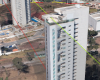
Yes, that is exactly the building where I'm searching it.
Yes, that is exactly the building where I'm searching it.
The problem is that, when returning to home, it started landing and stopped moving forward, because of battery level. And I wasn't with video feed, so, I did some movements on stick, in a blind way. Not so much. That's why I'm wanting to understand if fatal.log of RC can help with something more than just altitude, speed and distance from home.
Because It was connected. Only the connection between the controller and the mobile that was interrupted.Why do you think that the RC still had connection with the aircraft?
Because It was connected. Only the connection between the controller and the mobile that was interrupted.
I saw everything on controller until it was landed.
And all this is confirmed on the fatal.log file
503m.OK, so what was the home distance shown on the RC when it landed?
503m.
Yes. Exactly that.
And the landing was below 0, since the HP was on a rooftop of my apartment, on the 24 floor.


Rth was on 148m. Far above the buildings.At what height was your RTH altitude set to? If it was below 50m then it may have not got past that or nearby building. Green line is for RTH set to 50m relative to home point.
View attachment 53404
I'm thinking in use the angle x speed X time to estimate the distance ran from the rth original line.From your logs it seems it force landed with 6% battery left while RTH at 503 meters from home point at height -7m or -16m below home point altitude(24th floor). It may be crashed after connection lost as clearance sensor still showed value 255 so it may not have been close to ground while still landing and battery could have been shutdown in mid-air.
Draw some lines with possible angles from fatal.log but doesn't seem to align with Litchi log so these values indeed may not make any sense.View attachment 53393
Also tried to visualize RC data:
View attachment 53401

What mean the yellow line on your map? I was searching it more centered on the central line of the rth. 503m centered on it. But, if your yellow line shows some angle it was moving thru, it can be some meters aside from it.From your logs it seems it force landed with 6% battery left while RTH at 503 meters from home point at height -7m or -16m below home point altitude(24th floor). It may be crashed after connection lost as clearance sensor still showed value 255 so it may not have been close to ground while still landing and battery could have been shutdown in mid-air.
Draw some lines with possible angles from fatal.log but doesn't seem to align with Litchi log so these values indeed may not make any sense.View attachment 53393
Also tried to visualize RC data:
View attachment 53401


We use essential cookies to make this site work, and optional cookies to enhance your experience.