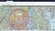
ALERT! ALERT! The reason why are all of the airplanes that are currently flying around Washington D.C. is because the Federal Aviation Administration (FAA) placed a Temporary Flight Restriction (TFR) over the entire Washington D.C. area. This is the largest TFR that I have ever seen before. Here are the details directly from the FAA: FDC 1/1155 ZDC DC .. FLIGHT RESTRICTIONS, WASHINGTON, DC. EFFECTIVE 1101102040 UTC [1:11pm 1/12/2021 EST] UNTIL FURTHER NOTICE. THIS NOTICE WILL REPLACE NOTAM 0/9463 DUE TO TECHNICAL ERROR, NO CHANGES IN RESTRICTIONS. PURSUANT TO TITLE 14 CFR SECTION 99.7, SPECIAL SECURITY INSTRUCTIONS. A. EXCEPT FOR FAA APPROVED DOD, LAW ENFORCEMENT, AND WAIVERED LIFEGUARD/AIR AMBULANCE FLIGHTS, ALL VFR AIRCRAFT OPERATIONS WITHIN 30NM OF 385134N/0770211W OR THE WASHINGTON /DCA/ VOR/DME, FROM THE SURFACE UP TO BUT NOT INCLUDING FL180 [18,000 feet], ARE RESTRICTED TO AN INDICATED AIRSPEED OF 180 KNOTS OR LESS, IF CAPABLE. IF UNABLE, THE PILOT MUST CONTACT THE APPROPRIATE ATC FACILITY AND ADVISE THEM OF THE AIRCRAFT'S OPERATIONAL LIMITATIONS. B. ALL VFR AIRCRAFT OPERATIONS WITHIN THE AIRSPACE BETWEEN 30 NMR AND 60 NMR [Nautical Mile Radius OF 385134N/0770211W OR THE WASHINGTON /DCA/ VOR/DME, FROM THE SURFACE UP TO BUT NOT INCLUDING FL180, ARE RESTRICTED TO AN INDICATED AIRSPEED OF 230 KNOTS OR LESS, IF CAPABLE. IF UNABLE THE PILOT MUST CONTACT THE APPROPRIATE ATC FACILITY AND ADVISE THEM OF THE AIRCRAFT'S OPERATIONAL LIMITATIONS PRIOR TO ENTERING THE 60 NMR OF THE WASHINGTON /DCA/ VOR/DME. This information is telling all AIRMEN [pilots] to slow their airspeed to less than 180 knots inside the 60-mile radius around Washington D.C.
"THIS IS NOT A DRILL". Go to: skyvector.com, scroll and minimize the map of the USA. Then scroll across to the Washington D.C. area. Move your mouse into the red and yellow area to see the TFR 1/1155 box will open, double click your mouse when you see a new page that shows the same information that I provided above is the in fact the REAL TRUTH. The TFR tells pilots that there is a SPEED LIMIT in the area around and above Washington D.C... until further notice from the FAA.
Shall we discuss about this issue that is currently happening in the United States!


