


You are using an out of date browser. It may not display this or other websites correctly.
You should upgrade or use an alternative browser.
You should upgrade or use an alternative browser.
Large MB 360 pano
- Thread starter DaveLewin
- Start date
The biggest I have created is a 46 mp from the mavic air 2. Greater than 100 mp would be a lot of pictures.

Thanks for that. I've managed to create 120MB files from 26/27 photos, which don't come out equirectangular, but can be turned into 2:1 with some photoshop manipulation. Turning that into a 360 is the bit I don't know how to do. [emoji51]The biggest I have created is a 46 mp from the mavic air 2. Greater than 100 mp would be a lot of pictures.
vfrailing
Active Member
I haven't done a 360 with the Mavic, but I have with both my P4P and I2. I do it manually, shooting each image with AEB5, and try to overlap each image by at least 40%.
I then process the HDR with Photomatix, and then use PhotoShop to File-Automate-Photomerge. I use auto layout option, and then select blend images, vignette removal, content aware fill. (Not Geo Distortion!). The file is then huge, but I have a pretty good machine. I work then to adjust any flaws.
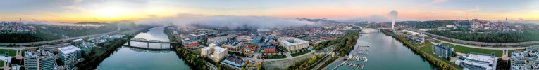
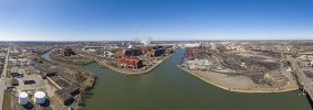
Here's are 2 360's. Pittsburgh is 401 full res (tif) and Church Pan is 1 GB. (That's from the I2)
Hope that gives you an idea of how to do it. I'm sure I could do it easier, it's just what I have developed.
I then process the HDR with Photomatix, and then use PhotoShop to File-Automate-Photomerge. I use auto layout option, and then select blend images, vignette removal, content aware fill. (Not Geo Distortion!). The file is then huge, but I have a pretty good machine. I work then to adjust any flaws.
Here's are 2 360's. Pittsburgh is 401 full res (tif) and Church Pan is 1 GB. (That's from the I2)
Hope that gives you an idea of how to do it. I'm sure I could do it easier, it's just what I have developed.
Attachments
Last edited:

Will try that, thank you.I haven't done a 360 with the Mavic, but I have with both my P4P and I2. I do it by had, shooting each image with AEB5, and try to overlap each image by at least 40%.
I then process the HDR with Photomatix, and then use PhotoShop to File-Automate-Photomerge. I use auto layout option, and then select blend images, vignette removal, content aware fill. (Not Geo Distortion!). The file is then huge, but I have a pretty good machine. I work then to adjust any flaws.
Here's are 2 360's. Pittsburgh is 401 full res (tif) and Church Pan is 1 GB. (That's from the I2)
Hope that gives you an idea of how to do it. I'm sure I could do it easier, it's just what I have developed.
JimWest
Well-Known Member
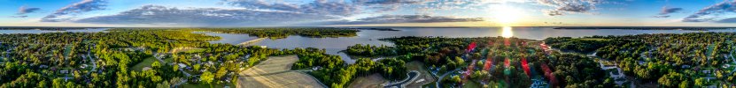
I've been doing it some. You can set the M2P to automatically take vertical shots (3 images) or horizontal, panoramic, or sphere (with 21+ images). You don't need to direct the drone once you've set it up. Just push the shutter button and don't touch anything else until you see the message "panorama successfully completed." You can then use the result that the Mavic automatically stitches together (which will produce a pretty small file), or you can take the individual images and stitch them together in Photoshop or another program. Fairly easy in Photoshop (File-- Automate-- Auto Merge), but it takes a while because you'll end up with real big files. This image of the Ford Rouge plant was stitched together from 21 shots and I ended up with a 245MB file.
Attachments
Awesome thank you. So how would I then turn it into an equirectangular size, for sharing (eg Facebook, Kuula). My objective, is to create really detailed 360 spherical panos. ThanksI've been doing it some. You can set the M2P to automatically take vertical shots (3 images) or horizontal, panoramic, or sphere (with 21+ images). You can use the result that the Mavic automatically stitches together (which will produce a pretty small file), or you can take the individual images and stitch them together in Photoshop or another program. Fairly easy in Photoshop (File-- Automate-- Auto Merge), but it takes a while because you'll end up with real big files. This image of the Ford Rouge plant was stitched together from 21 shots and I ended up with a 245MB file.
JimWest
Well-Known Member
Not sure what you mean by equirectangular.Awesome thank you. So how would I then turn it into an equirectangular size, for sharing (eg Facebook, Kuula). My objective, is to create really detailed 360 spherical panos. Thanks
Equirectangular, meaning 2:1 ratio.Not sure what you mean by equirectangular.
JimWest
Well-Known Member
I use Photoshop. Cropping is pretty easy to whatever ratio you want with the crop tool. Shouldn't be hard in other image editing programs, but I don't have experience with them.Equirectangular, meaning 2:1 ratio.
Cool, will give that a go. Thanks for your input. [emoji106]I use Photoshop. Cropping is pretty easy to whatever ratio you want with the crop tool. Shouldn't be hard in other image editing programs, but I don't have experience with them.
vfrailing
Active Member
Correct, using just yaw. The more overlap, the easier the stitch. With the P4P, I think it takes around 12 - 15 images to go 360. I try to start 180 from the object I am trying to get in the center.So from what I am getting you take the picture, turn the drone slightly and then take another picture...
Seldenm
Member
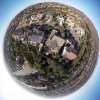
Try the free Microsoft Image Composite Editor. Google to find the download. I've used it for all my panoramas. Besides stitching, it gives you many different projection alternatives, cropping and export to a file. It does a fantastic job to stitching without artifacts, and it's fast too. Here is one example, a "tiny planet" projection. There were 25 or so 20mpixel images in the original. I output to a jpeg, that's why the file size is pretty small. Good luck!
Attachments
Thank you [emoji106]Try the free Microsoft Image Composite Editor. Google to find the download. I've used it for all my panoramas. Besides stitching, it gives you many different projection alternatives, cropping and export to a file. It does a fantastic job to stitching without artifacts, and it's fast too. Here is one example, a "tiny planet" projection. Good luck!
wordzenpix
Member
Nice work!I haven't done a 360 with the Mavic, but I have with both my P4P and I2. I do it manually, shooting each image with AEB5, and try to overlap each image by at least 40%.
I then process the HDR with Photomatix, and then use PhotoShop to File-Automate-Photomerge. I use auto layout option, and then select blend images, vignette removal, content aware fill. (Not Geo Distortion!). The file is then huge, but I have a pretty good machine. I work then to adjust any flaws.
Here's are 2 360's. Pittsburgh is 401 full res (tif) and Church Pan is 1 GB. (That's from the I2)
Hope that gives you an idea of how to do it. I'm sure I could do it easier, it's just what I have developed.
I tried this yesterday (AEB photos and merge them together) and it worked great! I love the result. I would say the automatic panorama feature works good, but if you want a custom pano or dont like how the auto one works, this is the way to do it!!I haven't done a 360 with the Mavic, but I have with both my P4P and I2. I do it manually, shooting each image with AEB5, and try to overlap each image by at least 40%.
I then process the HDR with Photomatix, and then use PhotoShop to File-Automate-Photomerge. I use auto layout option, and then select blend images, vignette removal, content aware fill. (Not Geo Distortion!). The file is then huge, but I have a pretty good machine. I work then to adjust any flaws.
Here's are 2 360's. Pittsburgh is 401 full res (tif) and Church Pan is 1 GB. (That's from the I2)
Hope that gives you an idea of how to do it. I'm sure I could do it easier, it's just what I have developed.
Cymruflyer
Well-Known Member
Take a look here in case it might be helpful to you.Has anyone ever created a large 360 pano (> 100MB)? If so, what is the workflow?
The 'normal' 360 is only about 20MB, but it would be great to create a more granular / detailed view.
Many thanks.
How to Shoot Drone Panoramas
In this video lesson, professional photographer David Johnston takes you into the woods for a tutorial on shooting drone panoramas.
 www.outdoorphotographyguide.com
I am not the owner of this thread but i tried this and it says i have to pay to watch the whole video. Am I doing something wrong?Take a look here in case it might be helpful to you.
How to Shoot Drone Panoramas
In this video lesson, professional photographer David Johnston takes you into the woods for a tutorial on shooting drone panoramas.
Similar threads
- Replies
- 39
- Views
- 7K
- Replies
- 0
- Views
- 798
- Replies
- 7
- Views
- 1K
- Replies
- 20
- Views
- 10K


DJI Drone Deals
New Threads
-

-
 2 Genuine DJI Mini 4 Pro, Mini 3 Series Plus Intelligent Flight Battery
- Started by Dogpilot
- Replies: 0
-

-
 Mini 4 Pro Istanbul where the East meets West - Eminönü
- Started by MPone
- Replies: 1
-
 Wanting to understand "Power Banks" and what I'll need....
- Started by MavicFlyer2
- Replies: 7
Forum statistics
