Hello all. I'm new here, and of course the 1st thing I post is a 'Please help me' thread. TIA, as I'm sure someone will be able to help me with a flight analysis and recommend if I have any chance to file a warranty claim for the loss. As well, if you have any recommendations on what to send DJI and how best to present the claim I'd appreciate it.
1st disclosure, total noobs, Mavic Mini is 1st drone and we have pretty limited flight time. This was an Xmas gift for my son and we haven't spent a lot time with it, and this is the 1st we've ever tried to analyze the flight data logs.
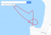
Short story is, flying over water (actually 1st time to do that) and having a blast. 3 minute flight total at a high elevation with an 8628' take-off elevation. Starting battery 39% with 24% remaining at the time of the incident. On returning the drone to home, manually, it began losing altitude. Drone was in sight, a couple hundred feet away and at about a 50' elevation. It began losing altitude, gradually at 1st then at an increasing rate. Lowered all the way to the water, hovered at the surface momentarily causing splash from the prop wash. Then it began to climb again, but after about 10' of gain it settled back all the way to the surface and slowly sank away.
It was a traumatic scene to stand there helplessly and watch it sink away, unretrievable, while my kid loses his ever-loving mind! Not fun. Although it wasn't far away, water was too cold and deep to attempt a retrieval.
Ok, so obviously high elevation flight with a relatively low starting battery is not a prudent move. Did it just not have enough volts to maintain altitude in that thin air? We had made several prior flights at these elevations with no issues, getting battery as low as 10% once with no ill effects. Not sure how to calculate the air density altitude, but wouldn't the software adjust the ceiling accordingly?? Probably No I suspect...****.
If someone could look over our flight data, or advise me on how to do the same, the link to airdata is below and Flight Record attached. I was hoping to find telemetry data on flight control input. While pilot error seems the most probable suspect here, at the time of the loss we thought we were doing everything we could to get it home. I believe it was in S Mode. What all else should we scrutinize?
Do I need to obtain the upgraded version of Airdata? Is PhantomHelp better? So....what do you see in there that I don't at the time of loss????
We appreciate any input and guidance.
Jim & Jaiden
1st disclosure, total noobs, Mavic Mini is 1st drone and we have pretty limited flight time. This was an Xmas gift for my son and we haven't spent a lot time with it, and this is the 1st we've ever tried to analyze the flight data logs.
Short story is, flying over water (actually 1st time to do that) and having a blast. 3 minute flight total at a high elevation with an 8628' take-off elevation. Starting battery 39% with 24% remaining at the time of the incident. On returning the drone to home, manually, it began losing altitude. Drone was in sight, a couple hundred feet away and at about a 50' elevation. It began losing altitude, gradually at 1st then at an increasing rate. Lowered all the way to the water, hovered at the surface momentarily causing splash from the prop wash. Then it began to climb again, but after about 10' of gain it settled back all the way to the surface and slowly sank away.
It was a traumatic scene to stand there helplessly and watch it sink away, unretrievable, while my kid loses his ever-loving mind! Not fun. Although it wasn't far away, water was too cold and deep to attempt a retrieval.
Ok, so obviously high elevation flight with a relatively low starting battery is not a prudent move. Did it just not have enough volts to maintain altitude in that thin air? We had made several prior flights at these elevations with no issues, getting battery as low as 10% once with no ill effects. Not sure how to calculate the air density altitude, but wouldn't the software adjust the ceiling accordingly?? Probably No I suspect...****.
If someone could look over our flight data, or advise me on how to do the same, the link to airdata is below and Flight Record attached. I was hoping to find telemetry data on flight control input. While pilot error seems the most probable suspect here, at the time of the loss we thought we were doing everything we could to get it home. I believe it was in S Mode. What all else should we scrutinize?
Do I need to obtain the upgraded version of Airdata? Is PhantomHelp better? So....what do you see in there that I don't at the time of loss????
We appreciate any input and guidance.
Jim & Jaiden
Attachments
Last edited: