DJI Mavic, Air and Mini Drones
Friendly, Helpful & Knowledgeable Community
Join Us Now

Lost mavic on 12-22-18 Can the RC files be analyzed?

CarRamrod

Member
Joined
Jan 4, 2017
Messages
10
Reactions
4
I was flying via, pix4d app. MY phone loast connection to my controller, but the controller was still connected to the mavic. Battery was extremely low and then lost connection. I believe it was returning to home but was far away and count get back in time. I was able ot get my flight record off my phone and showed my path and i searched there but nothing. So i dont thin my flight log from my phone is any good. the phone disconnected and i believe it continued flying. unless it doesnt do that.

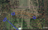
Is there anything you can get off the files on the RC. I think it continued on its programmed path, then either died, or started to RTH. i have walked the projected path and found nothing.

location to the RC files. Black box Files

I do remember the RC said the drone was 700ft away
 

Attachments

  • DJIFlightRecord_2018-12-22_[16-43-37][1].txt
    1.7 MB · Views: 15
Last edited:
It's not clear what happened at the end. The log just stops, and so the flight may have ended right there due to a battery disconnect. Or, if it was just a phone disconnect then it may have continued on the waypoint mission.

If the aircraft failed at the end of the log then it will be at that location - the last recorded point, or very close. If it kept going then it will have continued until it commenced RTH. Extrapolating the smart battery RTH level and battery % indicates that it would have just arrived at the end of the next leg (if the mission profile continued as it had been going), and would then have entered RTH at 18% at around 1300 seconds. Predicted autoland at 11% would have been 120 seconds later, and so it would have had plenty of reserve to get home - that would only take 35 seconds at regular RTH speed.

rth.png

motion.png

The image below shows the estimated RTH path had it made it that far.

1546617148083.jpeg

However - I don't like that hypothesis, because it requires two separate failures. Firstly the phone would have had to disconnect, then the aircraft would have failed to RTH as programmed. My first guess would be that the aircraft lost power of the FC crashed at the last recorded point.
 
Than you for the reply. I know for a fact the phone disconnected at some point and the drone continued to either fly its path or hover. it began its RTH at some point but when i pick the remote back up the mavic power was at 2% before it disconnected. and i believe the remote said it was 700ft away. i did a 700 foot radius and have a few areas i have my FIL going to look since i dont live there. It is his land. here are the couple places i tink it might be. I did go to the last location (end of the last known location) with no luck. SO my image shows the 4 areas i think i might be in.
 

Attachments

  • Capture.png
    Capture.png
    2.3 MB · Views: 25
Than you for the reply. I know for a fact the phone disconnected at some point and the drone continued to either fly its path or hover. it began its RTH at some point but when i pick the remote back up the mavic power was at 2% before it disconnected. and i believe the remote said it was 700ft away. i did a 700 foot radius and have a few areas i have my FIL going to look since i dont live there. It is his land. here are the couple places i tink it might be. I did go to the last location (end of the last known location) with no luck. SO my image shows the 4 areas i think i might be in.

Okay - well I can guarantee that it did not make it past the estimated location for low battery RTH unless you have some unusual aircraft flight settings. If it continued to fly then it will have started RTH from around that location.

1546621122208.jpeg

That does not explain, of course, why it didn't make it home. I guess it's worth checking the 700 ft intersection with that return path.
 
do you have that exact GPS cood. of the pin i can send to my FIL to go to and search?

Here's the full kml file with all those points and constructs. You will need to change the file extension back to .kml.
 

Attachments

  • 2018-12-22_[16-43-37].txt
    119.4 KB · Views: 10
  • Like
Reactions: CarRamrod
Was it a sunny afternoon? Just wondering, because that RTH path (233°) would have been almost directly into the sun (az. 238°, el. 4°), and that might have triggered obstacle avoidance and significantly delayed RTH.
I would just like to come back here and give an update. I went back up to the area I lost the Mavic and did another walk through. This was the 3rd walkthrough. Well... It was found. About 15 feet from the intersection of the 700 ft mark and path. It it crazy I hadn't found it yet as it was right near where I kept parking the sxs. But this field has about waist hight brush and bushes. So you really couldn't see mush around you unless you were on top of it .

Looks great, but had moister in it as a bunch of rain storms has rolled through on the past few months. I am drying it out a few days before I try to turn it back on.

I pulled the card out and saw it slowly reduced altitude before it hit a bush, so there really is no cosmetic damage to the drone.
 

DJI Drone Deals

New Threads

Members online

Forum statistics

Threads
131,131
Messages
1,560,132
Members
160,100
Latest member
PilotOne