DJI Mavic, Air and Mini Drones
Friendly, Helpful & Knowledgeable Community
Join Us Now

Mavic 2 Pro fly away upon pressing return home button.

A question for Slup and or Meta 4, what message appears in the txt flight log if a M2P disconnects from the controller whilst the drone is in flight? (reason = I want to check something)

I have had at least one proper disconnection with a Mavic 2 but I can not remember which flight, scanning the csv's produced by a command line usage of TXTlogToCSVtool i.e.

FORFILES /m *.txt /C "TXTlogToCSVtool /c @file @fname.csv"

I find 5 flights where a "Weak signal" message is recorded but I am not certain it relates to a disconnection.
The Fly app will report both weak signal and signal lost, aircraft disconnected, but the GO 4 app only reports weak signal, which means download link lost.
Except that most fresh water is non-conductive and won't short out electronics. If the lake was brackish, very brackish, or salt water, maybe, but even then probably not a rapid death. Loss of signal was the antenna altitude being sub-zero (perhaps even underwater) and the trees. And the drone reported WEAK SIGNAL; not loss of signal.

View attachment 137334
It doesn't need to short out all the electronics - an underwater antenna won't radiate. And that is a loss of downlink message - that's what "weak signal" means in the GO 4 app.
 
Have you tried to drop your phone in water ... a phone which isn't water tight & have a detachable battery, I have & it died instantly.

And to be honest ... will this lead to another possible outcome for the drone in this incident ?
You are right as to outcomes.

A phone may stop working when dunked in fresh water for an entirely different reason; but it's not the conductivity of the water shorting it out.
 
... "Weak signal" message is recorded but I am not certain it relates to a disconnection.
That message doesn't need to mean a full disconnect (telemetry + live view stopped)... usually a full disconnect without a reconnect just end the log recording... but can show "weak ..." in the end if the connection glitches somewhat before it goes out.
 
My Mavic 2 pro was returning and a police officer approached me and wanted me to move my car.I pressed the return home button and it came close, but then disconnected and drifted away. I lost all contact with It and I can not seem to locate it using the "find My drone" function on my controller. I have a smart controller.
doesn't it have a honing device in it so that I can find it? Why did it disconnect? It is dark out and late, so I will go out in the morning, but I really could use some insight!!!!
Thanks!!!
Did the cop scare you at all?


The drone didn't drift away. It was going to it's home point you failed to update when you moved your car.
 
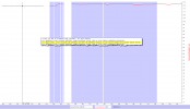
@PhiliusFoggg ... some additional info from how the GO4 app can do this with "weak signal". The blue areas is RTH & you can see where the gaps are in the height graph (= telemetry is missing), where I have placed the chart pointer, there it is a weak signal message. No other signal relevant message exists in the log.

1635354213419.png
 
The Fly app will report both weak signal and signal lost, aircraft disconnected, but the GO 4 app only reports weak signal, which means download link lost.
Thanks Sar104, sorry I should have included you along with Slup and Meta4. In each of the five logs, from 3 different M2Z's, the message appears only once in each log and the log seems to carry on recording perfectly well on the following lines. The time increment seems consistant across the line carrying the message, that puzzles me.
Maybe as Slup suggests, they were momentary glitches.

It prompts another question. If any, what channel, or in my language, "column" ( by name) in a csv of the logs tracks the signal strength?
I have gone throught the chart menus of CsvView and the column titles in a csv and saw nothing that leapt out at me.
 
Cheers Slup I have seen gaps like that in the CsvView charts before or straight line traces and took them to stem from interrupted connections but I haven't yet looked at the charts for these 5 M2Z logs. The logs in which I noticed those gaps etc. could well be from Phantoms or Mavic Minis.
 
Last edited by a moderator:
What my questions are leading to is an extension of
usually a full disconnect without a reconnect just end the log recording... but can show "weak ..."
i.e. is it possible that the drone did not crash but that it did suffer a full disconnection, recovered and then flew as Honeybush Swami witnessed? With the second 'part' of the flight being recorded in the next log.
I do see that there is a freaky pitch change right at the end of Honeybush Swami's log but I have seen at least one unbelievable pitch or roll angle for my Mavic Mini when it was caught in a gust and it was in mid air and remained flying.
 
Last edited by a moderator:
Cheers Slup I have seen gaps like that in the CsvView charts beforeor straight line traces ...
In CsvView for a TXT it's gaps ... but for a DAT the graph straight lines (keeping value until a new is reported)

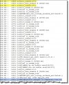
In the DAT log event stream for the very same flight as the chart I showed you earlier you can see a lot of the "glitches" marked the 2 first in yellow ... but then in blue, the connection is lost & RTH kicks in.

DAT.jpg

...i.e. is it possible that the drone did not crash but that it did suffer a full disconnection, recovered and then flew as Honeybush Swami witnessed?
I do see that there is a freaky pitch change right at the end of Honeybush Swami's log ...

Too be fully honest ... nobody knows (as it isn't recorded in the log), but that scenario is slim to none. The drone was in auto landing mode (descending with 3m/s) & the OP also kept the throttle down & the last reported height was well below the HP height in a reasonably flat landscape. To this you also need to add in a certain time after a disconnect until the failsafe action kicks in ... this just after the craft have reported a pitch of over 70 degrees down.

Nah ... the last rapid movements in the end of the log is when the drone hit the water surface.
 
Thanks Sar104, sorry I should have included you along with Slup and Meta4. In each of the five logs, from 3 different M2Z's, the message appears only once in each log and the log seems to carry on recording perfectly well on the following lines. The time increment seems consistant across the line carrying the message, that puzzles me.
Maybe as Slup suggests, they were momentary glitches.

It prompts another question. If any, what channel, or in my language, "column" ( by name) in a csv of the logs tracks the signal strength?
I have gone throught the chart menus of CsvView and the column titles in a csv and saw nothing that leapt out at me.
The Computed:downlinkSigQuality:C signal is a rough proxy for actual signal strength. It’s computed by CsvView and not actually in the .txt. CsvView assumes that records are produced at 10 hZ. Deviations from that are used compute the ”signal strength” as well as create gaps in the charts.
 
Sorry for your loss ... but your recollection of the events & what you commanded the drone to do doesn't marry up with what the flight log show ... not at all.

I agree with DJI's assessment to 100% & you will not be able point this to any other than yourself.

At 978sec into the flight you gave the drone a land command through the app (that button is next to the RTH button on the app ...) ... probably by mistake.

Immediately the drone started to descend with 3m/s ... just in the end of the log at about 1008sec you apply a combination stick input (full forward speed + full down) ... when you started to do this the drone was at approx 13m above your HP. Shortly after the drone hit the water surface, still with you applying full stick inputs for forward & down... & the connection was lost as the water shorted the electrical system.

All is shown here in this chart with data from your shared flight log.

Blue background color is appcommanded autolanding.
Red graph is height relative your HP
Black graph is horizontal heading speed
Light blue is Zspeed (vertical speed ... positive value = descend)
And all 4 dashed graphs is stick inputs

(Click on the chart to make it larger)

View attachment 137323

And your drone went under here where the red circle is ...

View attachment 137324

Here on a 3D pic with the green flight path there in the end together with comments ...

(Click on the pic. to make it larger)
View attachment 137328

Thanks so much for this analysis.
I can see why DJI and you see this as a pilot error and the drone is in the lake.
But I just talked to the officer that was with me when I was flying it back and pressed the landing button (By mistake thinking I was pressing the RTH). I pressed it right around where the drone was seen last on this map.

As I have stated and the officer cooperated, the drone come over us at the home point and continued to fly slowly into the forest behind us. He verified that it flew to us and was over land and slowly flew into the forest as I was franticly trying to communicate with it. He was called to respond to an accident and I stayed at the home point (where I could see the water and it was a quiet and windless night) for 1 hour after and did not see the drone.

The controller lost communication with the drone and it is beyond my understanding why.

But all this could be easily answered if the drone had a honing device on it. As you know, the find my drone feature is useless without communication with the controller.
And my insurance is contingent on me retrieving the drone, so the lack of a honing device is even more necessary.
My friends cat has a little chip imbedded to find her, why does the drone not have that????!!!

Thanks again !!!
 
A question for Honeybush Swami, since you are so adamant that the log is in error I have to ask, are you certian it is the correct log? Check the date and time stamp. I would also have a look and see if you can find any cached videos with a corroborating date and time stamp.
You would not be the first person to mix up logs.

Do you have the DAT flightlog for the posted log? See Sar104's post #27 in the MCDatFlightRecord foider, the name is probably 2021-10-20_18-13-04_FLY046.DAT.
yes. it is the correct log
 
As an aside, there may have been another drone in the sky that evening; drones aren't common things we see, but they're are up there. Especially in that neighborhood - those houses you flew over - enough money they might have a security company flying drones around and might even explain why cops showed up.

This camera view is also a hint your drone really was below tree level and descending into the lake.

View attachment 137338
I do not agree with that. Is that the last picture? also, that is pointing in the opposite direction which it was heading.
thanks
 
Have you tried to drop your phone in water ... a phone which isn't water tight & have a detachable battery, I have & it died instantly.

And to be honest ... will this lead to another possible outcome for the drone in this incident ?


And yeah ... it's a guess, but not based on the info provided in the log ... that message comes at 1014,8sec & the pitch, roll & yaw data doesn't show the drone to be nowhere near upside down. And there you also can see that it's 2 connection glitches before the drone goes off-line ... explaining the "weak signal" message.

View attachment 137340
I watched it come to me and over me on land. I was with a police officer who witnessed it and I just got off the phone with hime and he cooperated it! It did not flip over. I was coming toward the home point at a steady slow pace, but continued on int the dark forest behind the road.
I lost all communication when I pressed (acidentily thinking I was pressing RTH button) the landing button. I pressed it about the last place the log registered.
I see that it says it depended to the ground, but IT DID NOT.

Having just talked to the police officer that saw the same thing, I know that I am not crazy.

Thanks
 
The data shows what actually happened.
What you think you saw and what actually happened are two different things.
The drone went into the water 800 ft out from the launch point.
see the responses. but I just got off the phone with the police officer that was with me and witnessed the drone slowly fly over our heads and into the forest on the other side of the road. I am not crazy.

it was 800 ft. from the launch point where I pressed the landing button by mistake and then franticly pressed the RTH button on the smart controller.
The cop made me a bit nervous, but he just needed me to move my car.
But he did witness the same thing I did in relation to the drone flying slowly into the forest.
 
I lost all communication when I pressed (acidentily thinking I was pressing RTH button) the landing button. I pressed it about the last place the log registered.
I see that it says it descended to the ground, but IT DID NOT.

Having just talked to the police officer that saw the same thing, I know that I am not crazy.
You were flying in the dark and disoriented.
The police officer is probably not an experienced night time drone flyer either.

Now you just have to explain what the 3rd witness says about the incident.

How do you account for the recorded flight data showing the drone in autolanding descent for the last 36.8 seconds?
In that time it descended from 229 ft at 978.3 sec to water level at 1015.1 seconds, assisted by you holding the throttle full down right to the end where the drone hits an obstacle at water level and tips forward 70 degrees and signal is lost.

Pressing RTH after signal is lost won't have any effect (because signal has been lost).
Pressing RTH after the drone has crashed and sunk won't bring it back.

You know what you think you saw, but the 3rd witness doesn't get disoriented in the dark or flustered by police officers.
The recorded data shows the drone's position, speed, height and attitude as well as your joystick inputs for each 1/10th of a second, with high precision.
The 3rd witness is a lot more credible.
I understand this and this is why it is frustrating. I am determined to find the drone at this point.

The drone was all lit up and over our heads moving slowly and it was just getting dark. It was not a UFO, it was my drone.
I really wouldn't be pushing this if it was just operator error. I would be embarrassed and would not even post!
I hope you can stay tuned to find out the conclusion!
 

DJI Drone Deals

New Threads

Forum statistics

Threads
135,471
Messages
1,606,456
Members
163,916
Latest member
chrusse
Want to Remove this Ad? Simply login or create a free account