DJI Mavic, Air and Mini Drones
Friendly, Helpful & Knowledgeable Community
Join Us Now

Mavic Air Fly-away

Thanks ... this graph makes it much more clear. So in a nutshell you are saying the wind just blew it away ?

Yes - that was the end result. Drifting at 16 m/s (35 mph) with attitude maxed out implies a wind speed of at least 25 m/s (i.e. over 50 mph).
 
  • Like
Reactions: Kevjones777
Yes - that was the end result. Drifting at 16 m/s (35 mph) with attitude maxed out implies a wind speed of at least 25 m/s (i.e. over 50 mph).

Thank you for your help!

The drift caused by weak GPS signal + wind I had control over. It drifted really slow, no where near 16 m/s.

The true wind was at max 3 m/s.

Do you think that the warranty of DJI or the reseller will cover this?
 
Thank you for your help!

The drift caused by weak GPS signal + wind I had control over. It drifted really slow, no where near 16 m/s.

The true wind was at max 3 m/s.

Do you think that the warranty of DJI or the reseller will cover this?

The drift was quite slow to start with, until you climbed to 30 m where it looks like the wind was much stronger. Then it was fast, as indicated by the data. The aircraft was over 100 m away from you by then.

It's always worth asking DJI, but I would not be very optimistic. You took off with no GPS lock and no home point set, and when it started to drift with the wind you climbed instead of descending. After that you made no attempts at all to control the aircraft - it was simply trying to hold position. Those are very basic pilot errors.

DJIFlightRecord_2018-03-25_[10-03-43]_conv_03.png
 
So my Mavic Air flew away today. I started off with 100% battery, recorded RTH point with gps signal and all,
So basically none of this was true? No attack or disrespect towards the OP, but it’s interesting to note just how inaccurate witness recollection can be, especially when a more accurate recollection might make the witness look bad, even to only themselves (theoretically). The human mind. Almost as amazing as the Mavics’s mind.


Mike
 
The drift was quite slow to start with, until you climbed to 30 m where it looks like the wind was much stronger. Then it was fast, as indicated by the data. The aircraft was over 100 m away from you by then.

It's always worth asking DJI, but I would not be very optimistic. You took off with no GPS lock and no home point set, and when it started to drift with the wind you climbed instead of descending. After that you made no attempts at all to control the aircraft - it was simply trying to hold position. Those are very basic pilot errors.

View attachment 34377


I understand that the data indicates that there were 25 m/s of wind. Well, the data is wrong. The attached screenshot is of my local weatherstation's windlog, it shows 2,5 m/s. And that is a lighthouse a couple of km's from here. I promise you... 2,5 m/s at that lighthouse means practically no wind at all at my house.

I get why I should've waited for full GPS signal before take off, I made a mistake, I am a beginner. Although, this seems to be something that you learn from experience, as it doesn't say in the manual that you never should fly without GPS-signal. Should DJI just assume that I know this?

So how is the drone drifting 16 m/s in 2,5 m/s of wind without me doing anything? And why isn't it flying back to home?
 

Attachments

  • Skärmavbild 2018-03-25 kl. 16.44.11.png
    Skärmavbild 2018-03-25 kl. 16.44.11.png
    83.7 KB · Views: 125
So basically none of this was true? No attack or disrespect towards the OP, but it’s interesting to note just how inaccurate witness recollection can be, especially when a more accurate recollection might make the witness look bad, even to only themselves (theoretically). The human mind. Almost as amazing as the Mavics’s mind.


Mike


The 100% battery thing was my bad. I assumed it was fully charged and I didn't pay attention to battery %.
And it did have GPS signal at first, just weak signal. I assumed that it set the RTH point the moment it got a signal. Yeah I was dumb. Apologies. Yay for logs
 
  • Like
Reactions: mcjoshin
I understand that the data indicates that there were 25 m/s of wind. Well, the data is wrong. The attached screenshot is of my local weatherstation's windlog, it shows 2,5 m/s. And that is a lighthouse a couple of km's from here. I promise you... 2,5 m/s at that lighthouse means practically no wind at all at my house.

I get why I should've waited for full GPS signal before take off, I made a mistake, I am a beginner. Although, this seems to be something that you learn from experience, as it doesn't say in the manual that you never should fly without GPS-signal. Should DJI just assume that I know this?

So how is the drone drifting 16 m/s in 2,5 m/s of wind without me doing anything? And why isn't it flying back to home?

Those look like ground level wind measurements, so it's difficult to estimate the wind higher up, especially in that kind of terrain. The log data are self-consistent. Look at the second graph. The aircraft is facing 320° (NW). It is pitched up (backwards) by 21°, but is moving forwards at 8.5 m/s. It is rolled left by 29°, but is moving right at 14 m/s. That is only possible in a very strong NNE wind (clarification - blowing to the NNE).

That is also why it is not returning to the home point that was eventually set - the wind is too strong. It is already at max attitude (pitch + roll) and cannot even hold position, let alone return into the wind.

Beyond that I don't know what to say. If you want to believe that the log data are all incorrect then that's your prerogative. And maybe they are, but it would be very unusual for them to be both wrong and self-consistent. The event described by the log is also not inconsistent with your account - except for your insistence that there was no significant wind.


Well, something is off. There is just no possible way that it was 25 m/s of wind. That is full on storm. I cant remember the last time we had 25 m/s of wind here.
 
Well, something is off. There is just no possible way that it was 25 m/s of wind. That is full on storm. I cant remember the last time we had 25 m/s of wind here.

I agree that is a very strong wind. Do you get significant vertical wind shear in your area? Contact DJI and send them the log file. Maybe they will see something else amiss.
 
I'm not one of the pros who can interpret this data intelligently, but I do have a curiosity because I like to learn from other pilot's mistakes (sorry, but that is something we should all be doing).

I think the following is clear:

- Pilot took off before GPS lock (0 satellites at takeoff and only 4-5 when the pilot ascended). There was an app message about weak signal and positioning compromised.
- Without GPS lock, the Air would be relying on its downward VPS system, which is really only effective up to about 8m (according to the manual).
- Pilot ascended to 30m, which would be the maximum altitude without GPS lock and VPS is ineffective at that altitude, so drifting occurs.
- When 10 GPS satellites finally lock 46 seconds into the flight, speed shows 81.3 MPH, which is obviously bad data (likely due to the GPS repositioning), but drifting increases?
- Pilot loses transmission signal, making it difficult to fly the Air without line of sight (could the pilot see the drone at this point to attempt flying it back home?)

SO, it's clear that the biggest mistake made was not waiting for strong GPS and Home Point lock. But none of this explains why the Air drifted so quickly on its own if the actual wind speed was low and it locked on to 10+ satellites after 48 seconds into the flight . Should it not have just hovered without any pilot input? Surely the Air can compensate for mild winds when it has GPS lock, so either 1) the wind was much stronger than indicated, or 2) the pilot attempted to fly using the sticks or 3) something else was causing the Air to drift quickly.

Could it have been trying to fly to a home point that was somewhere else due to inaccurate GPS data? There was no indicate of return to home, but the manual mentions something interesting that I don't know is relevant or not:

"If the aircraft flies out of the max radius, it will fly back within range automatically when the GPS signal is strong" - Page 48 in the Flight Limits section

Could that have something to do with it? Maybe it didn't know where the flight radius was since the home point wasn't recorded and the GPS data was wonky? Just an idea, probably irrelevant.
 
  • Like
Reactions: Moon Man
I agree that is a very strong wind. Do you get significant vertical wind shear in your area? Contact DJI and send them the log file. Maybe they will see something else amiss.

I live by the sea in a generally flat terrain, so no, no vertical wind shear.
Will do.
 
I'm not one of the pros who can interpret this data intelligently, but I do have a curiosity because I like to learn from other pilot's mistakes (sorry, but that is something we should all be doing).

I think the following is clear:

- Pilot took off before GPS lock (0 satellites at takeoff and only 4-5 when the pilot ascended). There was an app message about weak signal and positioning compromised.
- Without GPS lock, the Air would be relying on its downward VPS system, which is really only effective up to about 8m (according to the manual).
- Pilot ascended to 30m, which would be the maximum altitude without GPS lock and VPS is ineffective at that altitude, so drifting occurs.
- When 10 GPS satellites finally lock 46 seconds into the flight, speed shows 81.3 MPH, which is obviously bad data (likely due to the GPS repositioning), but drifting increases?
- Pilot loses transmission signal, making it difficult to fly the Air without line of sight (could the pilot see the drone at this point to attempt flying it back home?)

SO, it's clear that the biggest mistake made was not waiting for strong GPS and Home Point lock. But none of this explains why the Air drifted so quickly on its own if the actual wind speed was low and it locked on to 10+ satellites after 48 seconds into the flight . Should it not have just hovered without any pilot input? Surely the Air can compensate for mild winds when it has GPS lock, so either 1) the wind was much stronger than indicated, or 2) the pilot attempted to fly using the sticks or 3) something else was causing the Air to drift quickly.

Could it have been trying to fly to a home point that was somewhere else due to inaccurate GPS data? There was no indicate of return to home, but the manual mentions something interesting that I don't know is relevant or not:

"If the aircraft flies out of the max radius, it will fly back within range automatically when the GPS signal is strong" - Page 48 in the Flight Limits section

Could that have something to do with it? Maybe it didn't know where the flight radius was since the home point wasn't recorded and the GPS data was wonky? Just an idea, probably irrelevant.

The home point was recorded at 49 s and was less than 100 m from the takeoff point, so that was not the problem. There were no recorded stick inputs after that time. The aircraft did not exceed maximum flight radius during the recorded part of the flight. The high and very high wind warning flags were set at 54.3 s, with a high wind warning on the app at 54.4 s.
 
OK - here is an alternative and more likely explanation. The initialized IMU heading for this flight, which is determined by the compass data at power up, was 44° - i.e. NE. Subsequent rudder inputs produce reasonable changes in yaw, and there are no indications in the log of any compass problems:

DJIFlightRecord_2018-03-25_[10-03-43]_conv_05.png

However, if you are correct and the initial yaw (heading) was actually 220° (SW), then the IMU yaw value was almost exactly 180° off. If that offset continued unnoticed (and there are no compass errors indicated during the recorded flight), then it will have had very serious consequences.

Specifically, if the aircraft started to drift on the wind, even slightly, then in order to hold position it will have applied directional thrust to counter the motion. In this case, the wind was blowing from the SW, and so it started drifting NE or NNE. Since the IMU indicated that the aircraft was facing that direction, the FC pitched the aircraft backwards to counter it. If the aircraft was actually facing SW then the backward pitch accelerated the drift rather than countering it. Similarly with the roll.

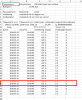
Correcting the initialized yaw value to your estimated original heading, and recomputing the forwards and sideways velocities with the revised yaw gives the following:

DJIFlightRecord_2018-03-25_[10-03-43]_conv_04.png

Now the recorded velocities are consistent with the applied pitch and roll - no significant wind needed to account for the motion.

If this analysis, based on your estimated initial yaw, is correct, then the problem was not wind driven at all (apart from some initial low-speed drift), but was instead due to significant magnetic interference at the launch point that was not detected by the FC, leading to the aircraft orientation being 180° off from reality. The FC cannot navigate in that situation, and attempting to hold position led to the aircraft flying NE at full speed.

I've seen a couple of these cases, where the aircraft would normally detect the problem and switch to ATTI returning full control to the pilot, but doesn't do so in time. Compass errors of around 90° cause the toilet bowl flight path (as predicted) and 180° errors cause full speed linear flight in the wrong direction.

DJI have replaced aircraft due to this kind of event where the takeoff location was the problem, probably because of a lack of notification of the compass error (even though it may inherently be undetectable), so it is worth pointing out what happened and asking them to cover it.
 
As a followup comment, if this is what happened then it is another example of the **extreme** importance of checking, before takeoff, that the aircraft heading indicated on the display by the arrow agrees with the actual direction in which the aircraft is facing. If it doesn't then you know you have magnetic interference or a compass problem. The FC has no way to perform that check - its only information on heading comes from the compass.
 
Lycus Tech Mavic Air 3 Case

DJI Drone Deals

New Threads

Members online

Forum statistics

Threads
131,282
Messages
1,561,633
Members
160,234
Latest member
jw312569