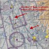
View attachment 75012
See that blue dashed line surrounding Salina airport? That’s class D from the surface up to 3800’ AGL, stay away from that. The Outer magenta shaded line is Class E starting at 700’ AGL, and there’s Class G below most of it except in the southwest quadrant where the blue hatched border is a restricted area due to the ICBM bunker

I’d be extra careful anywhere around your area near the agricultural fields during crop dusting time! Call those private fields near you (Silers and Tamarack on the map) in case they’re flying out from there. You can get their contact info here by searching for (Tamarack, KS), etc.
Up-to-date airport and fuel prices information. Communication frequencies, navigation and runway details. Extensive listing of FBO services and features, plus contacts. Browse by identifier and any geographic element
www.airnav.com


