DJI Mavic, Air and Mini Drones
Friendly, Helpful & Knowledgeable Community
Join Us Now

Photos for Counting Cars at shopping plaza

racervt911

Member
Joined
Apr 2, 2021
Messages
21
Reactions
35
Location
North Attleboro, MA
I have a project request to take birds eye view photos of a shopping plaza’s multiple parking lots during Black Friday between 11am-1pm. They want to count the cars to gauge shopping traffic.
I went to check out the site to see where the best place to launch my drone and still maintain VLOS. The plaza is fairly large and has some visual obstructions (trees, buildings) so I may have to land 2-3 times to relocate and/or change batteries. But, my main concern is making sure I don’t fly over people. Any tips or words of advice?
 
Even though the client is requesting birds-eye view photos, I am realizing that I probably won’t be able to do that without flying over people. Your suggestion is my most favorable option.
Thank you!
 
Not sure what drone you have, and while a drone parachute is not cheap, but a handy thing to have in such cases.
A quick search found these, reusable and pilot repackable.

Drone and UAV Parachute Recovery

Still not sure the US FAA would allow overflight of people / vehicles in mass, but it would certainly mitigate risks of crashing onto someone / something with force.
 
I have a project request to take birds eye view photos of a shopping plaza’s multiple parking lots during Black Friday between 11am-1pm. They want to count the cars to gauge shopping traffic.
I went to check out the site to see where the best place to launch my drone and still maintain VLOS. The plaza is fairly large and has some visual obstructions (trees, buildings) so I may have to land 2-3 times to relocate and/or change batteries. But, my main concern is making sure I don’t fly over people. Any tips or words of advice?
When the FAA says don’t fly over people they mean like crowds and not to loiter over them. They don’t want to you to fly your drone over a concert or festival for example. You can traverse over people on your way somewhere and you just have to try to avoid it if you can.

If the FAA literally meant you can’t fly over a person not even for a moment none of us would be able to get any kind of real actual work done.
 
Even though the client is requesting birds-eye view photos, I am realizing that I probably won’t be able to do that without flying over people. Your suggestion is my most favorable option.
Thank you!

Remind your client that birds look at most things at an angle from above and seldom look straight down. It's an interesting job and it sounds like the client is willing to do all the tedious counting.
 
I have a project request to take birds eye view photos of a shopping plaza’s multiple parking lots during Black Friday between 11am-1pm. They want to count the cars to gauge shopping traffic.
I went to check out the site to see where the best place to launch my drone and still maintain VLOS. The plaza is fairly large and has some visual obstructions (trees, buildings) so I may have to land 2-3 times to relocate and/or change batteries. But, my main concern is making sure I don’t fly over people. Any tips or words of advice?

Do you have a satellite image of the area?
We could get an idea of the best angles for the flight.

I think it would make a cool picture, ( a time lapse video would be great too!). However, I really don’t think it’s a good way of gauging their traffic.

I think they need a clicker.
Good luck and please keep me posted! I wanna see the crowded parking lot!
 
Last edited:
  • Like
Reactions: racervt911
There would be software that could count items in a photo that was represented of an item like vehicles.
They have this for trees, all sorts of things.

Local councils (cities) have software that can look at satellite / aircraft / drone images, and tell them if a photo from a few years ago has changed today in surface type (roofs) by X% (for planning offences).

Maybe it's an add on service some commercial drone operators could investigate and offer clients in such circumstances.
 
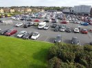
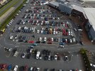
Here are two shots I took of a local car park a couple of months ago. Both were taken from the same place but at different heights. There's no need to overfly anything if you can find a a suitable take off spot near the perimeter of the car park and angle the camera like I've done here, unless they're insisting their bird's eye shot is 'straight down'. Maybe something like this would do them?

DJI_0314.JPG

DJI_0310.JPG
 
We've done this for retail clients several times. Fortunately, our clients gave us specific parameters (altitude, samples of angles needed etc etc). This was for counting cars going through an intersection and for cars going through a Drive-Thru during a specific time.

One client wanted video and the other wanted still images. On all of them we determined areas we could "loiter" and not be directly over traffic and not over areas of "people" congestion (building entrances, outdoor congregation areas etc etc). With just a little practice you can fly over cars & people without directly flying over them (mostly).
 
Great stuff from others, but I would suggest perhaps an obvious addition to your flight. INSURANCE. Let us know how it goes.
 
When the FAA says don’t fly over people they mean like crowds and not to loiter over them. They don’t want to you to fly your drone over a concert or festival for example. You can traverse over people on your way somewhere and you just have to try to avoid it if you can.

If the FAA literally meant you can’t fly over a person not even for a moment none of us would be able to get any kind of real actual work done.
I appreciate your perspective, and do understand where you are coming from. But, having worked for an aviation defense law firm for a short time years ago, and currently holding other FAA certificates for over 30 years, the FAA means “generally” not over people until your drone drops out of the sky and injures someone, then they mean “literally“ not over people.
I will probably just angle my camera up a little and shoot from along the perimeter just to be safe. Thanks again for the input, that why I put this out there. I wanted to hear all angles.
 
  • Like
Reactions: ratjr15
I appreciate your perspective, and do understand where you are coming from. But, having worked for an aviation defense law firm for a short time years ago, and currently holding other FAA certificates for over 30 years, the FAA means “generally” not over people until your drone drops out of the sky and injures someone, then they mean “literally“ not over people.
I will probably just angle my camera up a little and shoot from along the perimeter just to be safe. Thanks again for the input, that why I put this out there. I wanted to hear all angles.
Fair enough. Just make sure you don’t fall out of the sky and injure anyone then.
 
  • Like
Reactions: racervt911
There would be software that could count items in a photo that was represented of an item like vehicles.
They have this for trees, all sorts of things.

Local councils (cities) have software that can look at satellite / aircraft / drone images, and tell them if a photo from a few years ago has changed today in surface type (roofs) by X% (for planning offences).

Maybe it's an add on service some commercial drone operators could investigate and offer clients in such circumstances.
I thought there was software that did the counting for you, but I guess they don’t have it.
 
Here are two shots I took of a local car park a couple of months ago. Both were taken from the same place but at different heights. There's no need to overfly anything if you can find a a suitable take off spot near the perimeter of the car park and angle the camera like I've done here, unless they're insisting their bird's eye shot is 'straight down'. Maybe something like this would do them?

View attachment 139039

View attachment 139040
Thanks for sharing the photos! That helps me a lot! I think I can obtain the data they want with the camera angled up just a little.
 
  • Like
Reactions: The Fat Controller
Thanks for sharing the photos! That helps me a lot! I think I can obtain the data they want with the camera angled up just a little.
I've just checked back over the flight data for that day and my highest point was 55m (180ft). That would still leave you a fair amount of leeway to get a more useful height or angle.
 
I thought there was software that did the counting for you, but I guess they don’t have it.
There are quite a few packages that will do the counting. Cars in a carpark woulld be very easy to setup. We are using algorithms that can identify a shark among fish or swimmers. Its all about a learning software. Cool stuff becoming available all the tine
 
Do you have a satellite image of the area?
We could get an idea of the best angles for the flight.

I think it would make a cool picture, ( a time lapse video would be great too!). However, I really don’t think it’s a good way of gauging their traffic.

I think they need a clicker.
Good luck and please keep me posted! I wanna see the crowded parking lot!
I tried to attache a couple of contextual photos, but the files where too big. I was able to capture about 50% of the photos from birds eye view, mostly when that area of the lot was mostly empty and no people below. The rest I captured while hovering over the trees or buildings.
 
  • Like
Reactions: dozzn

DJI Drone Deals

New Threads

Forum statistics

Threads
134,490
Messages
1,595,594
Members
163,017
Latest member
al3597
Want to Remove this Ad? Simply login or create a free account