DJI Mavic, Air and Mini Drones
Friendly, Helpful & Knowledgeable Community
Join Us Now

Range issues. How to read the "Transmission" graph.

Ben_McPhee

Well-Known Member
Joined
Jan 15, 2018
Messages
120
Reactions
49
Age
43
Hey guys, I'm having some range issues with my Mavic Air 2. I get around 600m to 1.2km at best (Advertised range is 10km). I don't believe it's interference as I had the same issues in the middle of Australia where there definitely was none (I was in flight mode too).

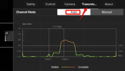
Among the trouble shooting steps DJI has asked me to perform is to "Check the transmission status during the flight", and they provided the photo below. The problem is, I have no idea how to interpret that. I understand that orange is sketchy, and red is bad, but the graph as a whole isn't explained anywhere, so what am I looking at?

It seems that the higher the peak, the more unstable the signal, but I don't understand how it correlates to the 1km/4km thing, or what the dBm/MHz read on on the left is. Or what the rectangle represents. And I can't find any literature on what are acceptable numbers to be seeing here.
1613147028158.png

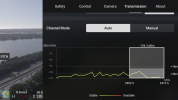
Today I undertook 2 flights, as far as I could before losing connection. (Not just image transmission - actual connection to the drone). 600m, and 1.2km. I didn't watch the transmission page the entire time, but all it seemed to be doing before the connection was lost was cycling approximately every 2 seconds between various green squiggly lines. No red that I could see. (And unfortunately I was concentrating on flying when the signal dropped out, so I didn't record the signal at that stage).

Below is a screencrab from my flight, taken AFTER the Auto RTH had been engaged after losing connection on the 1.2km flight. Only 400m from home, so everything was working as normal here.
IMG_7875.PNG

What are DJI expecting from me here? Because I'm definitely not happy with the range, but I need to be able to explain why.

Thanks in advance. :)

Ben
 
Hey guys, I'm having some range issues with my Mavic Air 2. I get around 600m to 1.2km at best (Advertised range is 10km). I don't believe it's interference as I had the same issues in the middle of Australia where there definitely was none (I was in flight mode too).

Among the trouble shooting steps DJI has asked me to perform is to "Check the transmission status during the flight", and they provided the photo below. The problem is, I have no idea how to interpret that. I understand that orange is sketchy, and red is bad, but the graph as a whole isn't explained anywhere, so what am I looking at?

It seems that the higher the peak, the more unstable the signal, but I don't understand how it correlates to the 1km/4km thing, or what the dBm/MHz read on on the left is. Or what the rectangle represents. And I can't find any literature on what are acceptable numbers to be seeing here.

View attachment 123714

Today I undertook 2 flights, as far as I could before losing connection. (Not just image transmission - actual connection to the drone). 600m, and 1.2km. I didn't watch the transmission page the entire time, but all it seemed to be doing before the connection was lost was cycling approximately every 2 seconds between various green squiggly lines. No red that I could see. (And unfortunately I was concentrating on flying when the signal dropped out, so I didn't record the signal at that stage).

Below is a screencrab from my flight, taken AFTER the Auto RTH had been engaged after losing connection on the 1.2km flight. Only 400m from home, so everything was working as normal here.

View attachment 123719

What are DJI expecting from me here? Because I'm definitely not happy with the range, but I need to be able to explain why.

Thanks in advance. :)

Be

Just to clarify are you using a clear line of sight with no obstructions such as flying from a vantage point. ?
You may want to try Manual mode with no HD at 5.8 to see if there is not a significant change.

I am also wondering are you using the lattest firmware in the fly app.

I recently added the Alien Dual Booster attena and the results were no so sweet with the Air 2 and some changes have been suggested.

 
You might like to install a video capture app. They are useful for this sort of otherwise dividing your attention thing.
Any recommendations?

iphone has one built in and I definitely ran it. But I have no idea why it only saved the last 5 minutes of my 2 flights to my phone. It was on for 2 entire batteries. :/

Even so, it was my own fault that I didn't check transmission the moment it dropped. Might need to test it again.
 
Just to clarify are you using a clear line of sight with no obstructions such as flying from a vantage point. ?
You may want to try Manual mode with no HD at 5.8 to see if there is not a significant change.

I am also wondering are you using the lattest firmware in the fly app.

I recently added the Alien Dual Booster attena and the results were no so sweet with the Air 2 and some changes have been suggested.

On this occasion, there was a row of trees that was probably slightly blocking my line of site. But a while ago I was in the middle of Australia with nothing in the way, but the same issues.

Latest firmware installed. (Actually, I think there was new firmware last week? So second latest. I updated literally 2 weeks ago).
 
I use xrecorder on an android phone. I recollect Iphones have a built in one and if you have an iPhone I do not know if xrecorder will work, sorry. Could the last 5 minute thing be some ting to do with permissable storage space?
 
Hey guys, I'm having some range issues with my Mavic Air 2. I get around 600m to 1.2km at best (Advertised range is 10km). I don't believe it's interference as I had the same issues in the middle of Australia where there definitely was none (I was in flight mode too).

Among the trouble shooting steps DJI has asked me to perform is to "Check the transmission status during the flight", and they provided the photo below. The problem is, I have no idea how to interpret that. I understand that orange is sketchy, and red is bad, but the graph as a whole isn't explained anywhere, so what am I looking at?

It seems that the higher the peak, the more unstable the signal, but I don't understand how it correlates to the 1km/4km thing, or what the dBm/MHz read on on the left is. Or what the rectangle represents. And I can't find any literature on what are acceptable numbers to be seeing here.

View attachment 123714

Today I undertook 2 flights, as far as I could before losing connection. (Not just image transmission - actual connection to the drone). 600m, and 1.2km. I didn't watch the transmission page the entire time, but all it seemed to be doing before the connection was lost was cycling approximately every 2 seconds between various green squiggly lines. No red that I could see. (And unfortunately I was concentrating on flying when the signal dropped out, so I didn't record the signal at that stage).

Below is a screencrab from my flight, taken AFTER the Auto RTH had been engaged after losing connection on the 1.2km flight. Only 400m from home, so everything was working as normal here.

View attachment 123719

What are DJI expecting from me here? Because I'm definitely not happy with the range, but I need to be able to explain why.

Thanks in advance. :)

Ben
I believe that this chart is trying to show the amount of interference versus frequency. The higher the interference the lower the maximum range possible. The 1km and 4km lines are threshold levels for each transmission distance. Theoretically, the interference needs to be below these levels to achieve the stated transmission distance. In asking to see this graph DJI is trying to determine if the fault is with the equipment or the problem is due to local interference.
 
  • Like
Reactions: Ben_McPhee
I believe that this chart is trying to show the amount of interference versus frequency. The higher the interference the lower the maximum range possible. The 1km and 4km lines are threshold levels for each transmission distance. Theoretically, the interference needs to be below these levels to achieve the stated transmission distance. In asking to see this graph DJI is trying to determine if the fault is with the equipment or the problem is due to local interference.
Ahhh, I think I get it. So in order for the drone to reach 4km away, the interference has to be under approximately 103dBm/MHz?

If that's the case, if I'm interpreting my readouts correctly, on my channel I was actually doing just fine at around 104.3? Except that within that rectangle, parts of the spike are above that, though they are still stable. Visually, it looks like I shouldn't have been able to reach 4km in this scenario (It actually dropped at 1.2km)

So, does that mean that if there doesn't appear to be local interference (No "unstable" spikes), that it would be an equipment problem?

Does that graph actually change as my aircraft gets further away? (I was expecting that if I looked at the graph at the moment of disconnection due to range, that there would be an unstable connection, and that it would be caused by range)
I would be careful in trying to interpret the graph too precisely but yes the lower the inference the farther it should reliably transmit and receive. The peaks within the band are less important than the average. The actual range you achieve is a function of the ratio of the desired signal and the interference, known as the signal to noise ratio. If you have something in between the controller and the drone it will reduce the desired signal. If the interference (noise) remains the same it will reduce the maximum range. It’s all about the ratio.
 
Last edited:
There is a reason some refer to RF signals as "black magic" (and I'm an engineer).
Sometimes there is no direct correlation between RF signal strength and operating range because of things like interference and multi-path. Even range extenders are subject to this phenomena (although I don't endorse those that exceed legal limitations).
I was obsessed with range at first, but after surveying the options (I occasionally use a "cheap" Yagi extender) and realizing there are inherent risks in flying too far beyond VLOS, I sort of "take what I can get" depending on the RF environment.
 
  • Like
Reactions: Camino Ken
The chart shows that your craft / controllers were operating in CE mode so the advertised range of 10 km does not apply because that's for FCC mode only.

The chart only shows the situation of the downlink but not the uplink. If there are problems on the transmit side of the controller or the receive side of the drone, you will have bad range but the transmission chart will still look normal.

I would suggest you to try again at remote places that are free from interference. Even in CE mode, the range should not be that bad. My M2P in CE mode can go out to 6.7 km and still maintain good connection.

 
  • Like
Reactions: Camino Ken
Lycus Tech Mavic Air 3 Case

DJI Drone Deals

New Threads

Forum statistics

Threads
130,587
Messages
1,554,127
Members
159,591
Latest member
Albrecht0803