DJI Mavic, Air and Mini Drones
Friendly, Helpful & Knowledgeable Community
Join Us Now

RTH did not work..

pascky999

Member
Joined
Nov 12, 2018
Messages
9
Reactions
2
Age
61
Hello,

Yesterday i sent the Mavic Pro flying about 1.5 mile away on a mountain forest slope to catch the nice color of the trees that we find each autumn in the Jura mountains near Geneva, Switzerland.

After 10mns, as there was 55% battery left, it gave me the message that there was just enough power to come back (not really true), so it asked me to confirm its intention to Go Home, which I did then got the voice of the lady saying "Going Home".
As i trust my Mavic, i then just put the remote control on a bench and started to discuss with my wife, after 2 mns i heard "Landing" but as i was not hearing the beast over us, i looked at the DJI app display and discovered that it was still more than a mile away about to plunge into a deep dark jungle, in a place where you don't want to go (450 m to climb at 5pm, almost dark, no trekking paths) .

I though that was it, that i was losing it; in panic mode i left the landing procedure as it was but then headed ferociously downhill to compensate and used the directions on the map to reach the home point and did that extra mile at 40km/h, then it was saved (only 14 % battery left when landed)

What happened really? why did it not come back as it always does when RTH is triggered? I never lost GPS connection, there was no alteration of signal, all was ok, just some wind gust at high altitude, but very manageable.

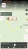
See the screenshot of DJI map and the hostility of the place at 5pm in winter.
 

Attachments

  • RTH.jpg
    RTH.jpg
    289.1 KB · Views: 206
  • IMG_7200.jpg
    IMG_7200.jpg
    684.9 KB · Views: 207
  • Like
Reactions: Elton Hammonds
Here's what happened. You were 2,600 feet above the landing point when you initiated RTH at 9:27, with 55% remaining. Your drone flew back to you at that 2,600 ft altitude for the next 2,000 feet @10mph (because it's fighting ridiculous winds at that altitude) until it hit 34% remaining. At this point you were still 3,700 feet away and the craft detected it could not make it, so it began to auto-land at the 12:40ish minute mark.
You did not react for a whooping two minutes from the auto-land announcement, because the first detection of upward throttle was at about 14:40 with a loss of 1,400ft of altitude. Then it takes you almost a minute before you push the controls to the forward position at the 15:25, at which point you continue flying back at an altitude of 1,200 feet as it auto-lands and descends for you.


So, basically it was poor choices by you. You should not have set down the controller, and you should have maintained your altitude to no more than 150m AGL. Also, I hope you realize that you must have an insurance policy for one million CHF to fly your drone.
 
2600 Feet! Insane! In the US thats a huge no-no ! Perhaps in Switzerland its accepted?
400 Feet AGL here in the states is the max that the FAA states.
 
As explained by @Just_nick, the problem was your altitude. The FC dynamically calculates two parameters during flight - the battery level at which it needs to return home, and the battery level at which it needs to start landing in order to make it to the ground. In this case, because you were so high above the home point, the critical landing battery level was, itself, quite high - 34% to be precise at your maximum altitude. As a result it switched from RTH to autoland when the battery fell to that level:

Graph0.png

The wind was strong at the top, which was approximately level with the ridge line, at one point exceeding 70 km/hr from the south.

1542052185159.jpeg


As a result it was only managing around 4 m/s in RTH, which delayed it on the return trip.

Graph1.png
 
2600 Feet! Insane! In the US thats a huge no-no ! Perhaps in Switzerland its accepted?
400 Feet AGL here in the states is the max that the FAA states.

No, it's very much not accepted. Switzerland has a 150m altitude limit, and drones are not allowed to fly BVLoS.
 
2600 Feet! Insane! In the US thats a huge no-no ! Perhaps in Switzerland its accepted?
400 Feet AGL here in the states is the max that the FAA states.

It's altitude AGL that matters, not altitude above the home point, which is what the logs report. If you compare the aircraft altitude with terrain elevation, and subtract to get aircraft altitude AGL, the result does reflect that the aircraft was flown up the side of a mountain:

Graph2.png

However, it still ended up 400 m (1600 ft) AGL on the return journey since it did not descend as it moved back towards the home point.
 
hello just_nick and Sar104,
Thanks very much for your explanations, problem was then the wind which was so strong that the aircraft was drifting and assumed it could never go back at such distance and altitude, until it reached a lower attitude where the wind was not so strong and i could bring it back ( when i woke up). There is always a huge wind at around 1300m especially near the edge which is the top of the ski resort (La Faucille), on the other side of the mountain. The 3D description is amazing. The location is actually in france at the border with Switzerland. Here the max altitude permitted by Mavic is 500m, so my differencial altitude was within limits, although i had to climb 800m to reach the ridge. Yes i had to unlock altitude which is almost mandatory when you live against the jura on one side and 50 kms from the Alps on the other, very frustrating not to reach the top of these mountains when you see it. Anyway i am new to this forum and i can see it has passionate pilots like myself. Thanks again. Pascal
 
  • Like
Reactions: Elton Hammonds
hello just_nick and Sar104,
Thanks very much for your explanations, problem was then the wind which was so strong that the aircraft was drifting and assumed it could never go back at such distance and altitude, until it reached a lower attitude where the wind was not so strong and i could bring it back ( when i woke up). There is always a huge wind at around 1300m especially near the edge which is the top of the ski resort (La Faucille), on the other side of the mountain. The 3D description is amazing. The location is actually in france at the border with Switzerland. Here the max altitude permitted by Mavic is 500m, so my differencial altitude was within limits, although i had to climb 800m to reach the ridge. Yes i had to unlock altitude which is almost mandatory when you live against the jura on one side and 50 kms from the Alps on the other, very frustrating not to reach the top of these mountains when you see it. Anyway i am new to this forum and i can see it has passionate pilots like myself. Thanks again. Pascal

The wind was an issue, but another problem was your decision to use RTH - in that situation it flies back to the home point at whatever altitude it is at when you select RTH. In this case that was far higher than optimal - keeping it in the stronger wind field. It would have been better to fly the aircraft down the mountain, and possibly select RTH when it was at a lower altitude.

That would also not have resulted in a UAV not under visual control flying over 400 m above the ground - an altitude that could easily put it into conflict with air traffic. You really shouldn't do that. The 500 m altitude limit in the Mavic firmware is unrelated to local law - I seriously doubt that French law permits UAVs to be flown at that altitude AGL.
 
General Rules for Flying a Drone in France
Based on our research and interpretation of the laws, here are the most important rules to know for flying a drone in France.

  • Drone pilots must maintain a line of sight with their drones at all times. If a visual observer is tracking the drone, the pilot may fly out of his or her own range of sight.
  • Drones may not be flown at night (unless with special authorization from the local prefect).
  • Drones may not be flown over people; over airports or airfields; over private property (unless with owner’s authorization); over military installations, prisons, nuclear power plants, historical monuments, or national parks. Use this map to locate flight restrictions by geolocation.
  • Drones may also not be flown over ongoing fires, accident zones, or around emergency services.
  • Drones may not be flown above 150 meters (492 feet), or higher than 50 meters (164 feet) above any object or building that is 100 meters (328 feet) or more in height.
For more information on France’s drone laws, see this page on the French Civil Aviation Authority website as well as this detailed legal report.
 
  • Like
Reactions: Flynz
Took me 2 seconds to find that information. I’m not one of the drone cops that love to post their opinion s here and show us all how clever they are, but I would recommend you know the basics of your local regs. Whether you keep to them or not, at least you don’t look silly by claiming you know rule but really have no idea
 
In situations like this at such elevation and wind speed I always click into Sport Mode using the switch on the side of the remote and then pull left stick down to decend quickly and then when I get lower below the really strong wind currents I fly back to my home point.

Has not failed me once so far. :)
 
Took me 2 seconds to find that information. I’m not one of the drone cops that love to post their opinion s here and show us all how clever they are, but I would recommend you know the basics of your local regs. Whether you keep to them or not, at least you don’t look silly by claiming you know rule but really have no idea

So, just impersonating a drone cop?
 
I wouldn't have thought it would take that much energy to descend, and that it would cause RTH to be cut short.
To save time though, I have manually descended as it's heading home when I was at higher (legal) altitudes. At least I have with my P3, can't be sure I did so with my M2Z

Anyway, you can override critical landing by countering decent rate with throttle.
Billy Kyle was able to fly straight at 0% for quite some time hoping he'd make it to a shore rather than it take a bath.

It takes less energy to descend than to ascend, but not that much less, as you can clearly see in the first graph in post #8 above. It cuts short RTH and auto lands to prevent it from dropping out of the sky.
 
hello just_nick and Sar104,
Thanks very much for your explanations, problem was then the wind which was so strong that the aircraft was drifting and assumed it could never go back at such distance and altitude, until it reached a lower attitude where the wind was not so strong and i could bring it back ( when i woke up). There is always a huge wind at around 1300m especially near the edge which is the top of the ski resort (La Faucille), on the other side of the mountain. The 3D description is amazing. The location is actually in france at the border with Switzerland. Here the max altitude permitted by Mavic is 500m, so my differencial altitude was within limits, although i had to climb 800m to reach the ridge. Yes i had to unlock altitude which is almost mandatory when you live against the jura on one side and 50 kms from the Alps on the other, very frustrating not to reach the top of these mountains when you see it. Anyway i am new to this forum and i can see it has passionate pilots like myself. Thanks again. Pascal

The max AGL altitude you can fly is 150m
 
You are a pilot.
But yet, it makes sense to you to leave the controls and chit chat with your wife, leaving the aircraft with no one at the controls?

Do you want the crew to do the same the next time you set foot in an airliner?

That plus the regulations that you did not obey shows a serious lack of judgment. Pls consider doing your hobby more seriously, or your aircraft will not last long...
 

DJI Drone Deals

New Threads

Forum statistics

Threads
131,261
Messages
1,561,418
Members
160,214
Latest member
AVI Drones