DJI Mavic, Air and Mini Drones
Friendly, Helpful & Knowledgeable Community
Join Us Now

RTH Question ?

Pacefast

Well-Known Member
Joined
Apr 22, 2023
Messages
340
Reactions
369
Age
62
Location
uk
I am sitting on a mountain top at 6000 feet set a RTH at 150 feet so it should climb to 6150 feet to return to me !
I descent following the mountain contour to 4000 feet ASL while keeping below 400 ft AGL following the contour.
I lose sight of the drone and press RTH ! Does it climb vertically 2150 feet hence busting the 400 foot limit or what does it do ?
This is aldo relevant flying up a Skyscraper which is legal to 120 feet ??? above the Skyscraper top
With all the confusing regs and programming to stop the drones going high ????
 
If I'm not mistaken the RTH is based upon launching point.
 
  • Like
Reactions: Paul Harvey and shb
Let me simplify that for you, if I understand you correctly:

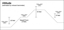
You take off from the top of mountain, no matter how high it is, so that's 0. You set the return to home to 150 so when triggered, the drone will raise to 150 above the take off point or if it is already higher, it will stay higher.

While flying, you descend to -100 so you are below the take off point and you lose the signal and the return to home is triggered.

According to the feature, the drone will rise from -100 to 150 and then return home. This is based on the traditional return to home drone sequence.
 
According to the feature, the drone will rise from -100 to 150 and then return home. This is based on the traditional return to home drone sequence.
If the drone is currently below the takeoff point when RTH is initiated (meaning the current altitude is below 0), it will ascend to 0 feet (the takeoff point) and then up to the RTH altitude (150 feet in this case).
 
Does it climb vertically 2150 feet hence busting the 400 foot limit...
This seems to be the question that the others have not specifically covered. And the answer to that is yes. Unless I'm mistaken, none of the DJI models can automatically follow the terrain back up the mountain. So it will go straight vertically until it reaches the RTH set height. Thus ending up more than 2150 feet above the ground below before it starts heading home.
 
So it will go straight vertically until it reaches the RTH set height.
Correct. And I did answer that in my reply above.
 
This is aldo relevant flying up a Skyscraper which is legal to 120 feet ??? above the Skyscraper top
With all the confusing regs and programming to stop the drones going high ????
EDIT: I just realized that the OP is from the UK. This information applies to the US only.
------------------------------
If you have a Part 107 rating, you're allowed to fly 400' above structures if you remain within 400' laterally of the structure.

For those flying under the 44809 recreational rules, there is no allowance for increased altitude above structures.
 
Last edited:
Correct. And I did answer that in my reply above.
Yes, you and @mavic3usa both stated that the drone will rise to the RTH setpoint. But both reduced the altitude being covered to only a couple hundred feet. It seemed to me that the OP was mostly concerned with the question of whether the drone would now be greater than the permitted 400' AGL in their scenario. Obviously, it would be. But nobody else bothered to mention it.
 
  • Like
Reactions: natgild
Yes, you and @mavic3usa both stated that the drone will rise to the RTH setpoint. But both reduced the altitude being covered to only a couple hundred feet. It seemed to me that the OP was mostly concerned with the question of whether the drone would now be greater than the permitted 400' AGL in their scenario. Obviously, it would be. But nobody else bothered to mention it.
Whenever this topic comes up, people often construct elaborate scenarios which muddies the waters. It's rather simple if one just remembers the aircraft will always ascend to the takeoff point (which is 0 feet on the screen in DJI Fly) and then ascend to the RTH altitude from that point.

But, you're correct -- I didn't address the exact scenario above. However, my answer can be applied to that scenario and any others the OP can come up with.

Here's a picture that might help:

1699640781040.png
 
  • Haha
  • Like
Reactions: okw and mavic3usa
Don't some of the more recent drones choose the most economical flight path to home and rely on OA etc. to avoid obstacles? I.e they might fly upslope in these circumstances but it would be a 'hairy' and perhaps risky return.

If so, @Pacefast , the drone's model is required information and a read of the drone's manual would answer the question. Really a read through the RTH section of the manual is a MUST, for your own happiness if nothing else.


The very basic behaviour for a simple drone that was beyond any distance from the home point thresholds would be, climb to RTH height i.e. climb those 2150ft and then move horizontally.
With later drones the behaviour gets more complicated.
However I would question the wisdom of being that low on a partially used battery, 2150ft is one heck of a climb on a partially empty battery.

With regards to the tall structures, I believe the UK current rule is 400ft of the CLOSEST GROUND full stop i.e. building height is not taken into consideration. But, weight depending, you shouldn't be over a building at all unless you have the owner's permission.
In mainland Europe there appears to be a slight allowance for an increase in permissible height but again that is with the owner's permission.

Besides, there aren't many places in the UK that I can think of where -2000ft would be practical
 
Don't some of the more recent drones choose the most economical flight path to home and rely on OA etc. to avoid obstacles? I.e they might fly upslope in these circumstances but it would be a 'hairy' and perhaps risky return.
Yes, there are scenarios other than ascending straight up to the RTH altitude and then flying back to the home point. It's always a good idea to read the manual specific to the DJI model so you're prepared for the action the aircraft might take when RTH is initiated in the various scenarios covered in DJI's manuals.
 
Don't some of the more recent drones choose the most economical flight path to home and rely on OA etc. to avoid obstacles?
Agreed which is why I stated "This is based on the traditional return to home drone sequence." There are RTH options that permit to do modify the behavior otherwise. I definitely switch OFF those features until I can better understand them.

I also didn't read into the "AGL violation" aspect of the thread titled "RTH ?" which is why I said I would "simplify" because I thought the poster was editorializing. I live in a relatively flat area so I don't get to handle a lot of AGL or below take off point type of scenarios. I too have often wondered if the RTH has a "relative" aspect to it but it is mostly absolute. I wish you could tell it, for example, to simply rise 150 feet from wherever it is as an option.
 
@Yorkshire_Pud my Air 3 if bypass is active and optimal is selected as the RTH feature does indeed return following the contours of the ground beneath itself, and the OA will avoid abstacles ,i have tried it for a short distance 500ft away and at minus 20ft altitude from the home point,it climbed up to about 25 ft, and then turned and flew back
i must say it was a rather butt clenching moment, as it climbed back up to where i took off from and landed back on the mat ,and it does it quite fast as well ,i had my finger poised over the pause button just in case,but to be honest with you ,as you say being at over -2000 ft down in a valley,after taking off at the top, would be quite a feat in itself, not only for signal penetrtion but for a visual on the drone ,if and when i fly in the beacons where i live ,and are going down into a valley , so a negative height ,then i would set the RTH height to no more that 50ft as it reduces the amount of effort that the battery needs to get back ,i have yet to try the optimal setting in such a scenario
 
  • Like
Reactions: Joethedrone and okw
@Yorkshire_Pud my Air 3 if bypass is active and optimal is selected as the RTH feature does indeed return following the contours of the ground beneath itself, and the OA will avoid abstacles ,i have tried it for a short distance 500ft away and at minus 20ft altitude from the home point,it climbed up to about 25 ft, and then turned and flew back
i must say it was a rather butt clenching moment, as it climbed back up to where i took off from and landed back on the mat ,and it does it quite fast as well ,i had my finger poised over the pause button just in case
What was the actual flight path @old man mavic ?
Just wondering if it was a series of steps up the slope or if it truly followed the contours etc.?
I have flown drones SLOWLY up slope using "landing protection" to force the climb but I wouldn't fancy any thing faster LOL
 
@Yorkshire_Pud i stood on a high spot and flew the drone down below me through a small undulating section between bushes and small trees which gradually sloped downwards as it went untill i finished at minus 20 ft altitude below the take off point i could still clearly see the drone, and could probably have gone further, but as i was only at about 10ft altitude above the ground where the drone was ,i decided to call it a day and try the optimal RTH, to see if it would fly back as such a low height ,or climb up to the RTH set height ,and then just come straight back ,like normal, i had flown out in cine mode and it just came straight back ,when i say follows the contours, i meant it went up only high enough for the downwards sensors to detect the ground beneath it, as it came back ,but it did rise up as it flew back as the ground beneath it did
i would imagine that if the home point ,was in a valley and the drone was up at the top of a peak then ,it would do the opposite, and reduce its altitude as it flew back, to reduce the distance it has to travel ,have not tried that yet
 
@Yorkshire_Pud my Air 3 if bypass is active and optimal is selected as the RTH feature does indeed return following the contours of the ground beneath itself, and the OA will avoid abstacles.

How can the drone know the elevation above ground in order to follow the terrain? The barometric altimeter doesn't provide that information. As it can in the preset RTH mode, it can bypass obstacles, but can't sense altitude above ground level.

From the Mavic 3 manual, no mention of altitude.

Screenshot 2023-11-10 153335.jpg
 
How can the drone know the elevation above ground in order to follow the terrain? The barometric altimeter doesn't provide that information. As it can in the preset RTH mode, it can bypass obstacles, but can't sense altitude above ground level.

From the Mavic 3 manual, no mention of altitude.

View attachment 170013
Maybe you need to read the excerpt from the manual again. It mentions altitude twice, and how it adjusts.
 
  • Like
Reactions: old man mavic
@MS Coast when the drone is within the range of the downwards facing sensors then it is able to know its height above the surface , if the drone is outside of the sensors range ,then it will start to loose altitude, as it comes back ,until it has that information ,it doesnt just stay at a preset height ,of course using this system is basically letting the drone fly completely autominously planning its own route back home ,and as you stated above in your post ,in order for it to do so, it requires a suitable enviroment, and sufficient light for the sensors to operate correctly
 
How can the drone know the elevation above ground in order to follow the terrain? The barometric altimeter doesn't provide that information. As it can in the preset RTH mode, it can bypass obstacles, but can't sense altitude above ground level.

From the Mavic 3 manual, no mention of altitude.

View attachment 170013

Up to 30' the drone can detect AGL with the IR ToF sensors. On the A3 I think this extends to 40', but don't rely on my statement here.
 
  • Like
Reactions: old man mavic
Lycus Tech Mavic Air 3 Case

DJI Drone Deals

New Threads

Forum statistics

Threads
134,443
Messages
1,594,825
Members
162,978
Latest member
dojin23