DJI Mavic, Air and Mini Drones
Friendly, Helpful & Knowledgeable Community
Join Us Now

SEEKING PRESET FLIGHT AND PHOTO STICH INFORMATION

M3AN_BASS

New Member
Joined
May 14, 2019
Messages
4
Reactions
16
Hello all,
My name is Philip. I work for Trout Unlimited, a non-profit that focuses on habitat enhancement and conservation for salmonid species. I general do field hydrology work(flow measurements and creek/river monitoring), but have been asked to do some work with my drone (Mavic Air 1).

What I would like to do is create a preset flight path at 300’ taking pictures of a designated area and then stitch those pictures together to create one large image. Is this possible with my drone?

Any help would be greatly appreciate.
Thank you,
 
What I would like to do is create a preset flight path at 300’ taking pictures of a designated area and then stitch those pictures together to create one large image. Is this possible with my drone?
What you are asking about is photogrammetry and you would like to create an orthophoto mosaic.
Yes, it's possible with your drone.
You would need to use a mapping app like DroneDeploy to plan the mission, fly the mission and acquire the images.
Then you would need to use specialised software or pay for DD or another service to combine the images and create the map.

Here's an example of an orthophoto compiled from 380 overlapping images on a 120 acre site.
8623_Sancus%20ortho_sm-X3.jpg

The full size is 32000 x 24000 pixels and has great detail.
You can open it in Google Earth or a GIS program to measure and analyse.
S%20map_3-X3.jpg
 
  • Like
Reactions: M3AN_BASS
What you are asking about is photogrammetry and you would like to create an orthophoto mosaic.
Yes, it's possible with your drone.
You would need to use a mapping app like DroneDeploy to plan the mission, fly the mission and acquire the images.
Then you would need to use specialised software or pay for DD or another service to combine the images and create the map.

Here's an example of an orthophoto compiled from 380 overlapping images on a 120 acre site.
8623_Sancus%20ortho_sm-X3.jpg

The full size is 32000 x 24000 pixels and has great detail.
You can open it in Google Earth or a GIS program to measure and analyse.
S%20map_3-X3.jpg
Thank you. I’ve downloaded the app, created an account, and will run a test site tomorrow. Do you run the app through a tablet or computer?
 
Thank you. I’ve downloaded the app, created an account, and will run a test site tomorrow. Do you run the app through a tablet or computer?
You run it on the phone or tablet that you normally fly with.
Here's a screenshot of the app during a flight mission:
i-fvtdmgg-L.png
 
  • Like
Reactions: M3AN_BASS
If the costing of any of the above mentioned does not bother you and you're not fine with some quality issues, you may ignore my message below.

If you're looking to just stitch some simple photos together and don't need georeferenced orthos, dtms etc. you might find that something like Adobe's Lightroom will fit the pocket better and will still provide nice large stitched aerial shots. I haven't exactly tested it out over extremely large areas - only a plot that is about 1ha with approx 25 photos, but it worked fine for me to get a general idea of the plot. The detail was surprisingly good. I took the photos manually, so I reckon that takes away the need for planning software aswell. Lightroom does have a 7 day free trial, so you can test it out with one of your datasets.
 
  • Like
Reactions: M3AN_BASS
You run it on the phone or tablet that you normally fly with.
Here's a screenshot of the app during a flight mission:
i-fvtdmgg-L.png
Thank you so much for the help!
I created the flight plan and flew this morning, it was a much easier process than I had anticipated. I have now started the upload process. I have 2 more quick questions.
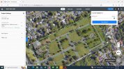
I have attached a screen shot of the Drone Deploy desktop after initiating the upload. I have yet to see any progress on the upload and it has been roughly 20 minutes. Is this typical or do I need to do something further?

Lastly, some of the sites I will be mapping in the future will be in remote locations with no cell or Wi-Fi, will this be an issue?

Thank you again!
 

Attachments

  • 9E1AA262-888B-4E5C-B5D8-542261CCC649.jpeg
    9E1AA262-888B-4E5C-B5D8-542261CCC649.jpeg
    653.5 KB · Views: 3
I have attached a screen shot of the Drone Deploy desktop after initiating the upload. I have yet to see any progress on the upload and it has been roughly 20 minutes. Is this typical or do I need to do something further?
I'm not sure as I process the images myself and don't upload to DD.
Lastly, some of the sites I will be mapping in the future will be in remote locations with no cell or Wi-Fi, will this be an issue?
If I haven't used DD for a while (maybe a month or more ?), it will ask me to Login again and you need internet for that.
But if you've used the app recently, it should work just fine without any internet data.
 
Lycus Tech Mavic Air 3 Case

DJI Drone Deals

New Threads

Forum statistics

Threads
131,152
Messages
1,560,448
Members
160,128
Latest member
FNG_