DJI Mavic, Air and Mini Drones
Friendly, Helpful & Knowledgeable Community
Join Us Now

Updated place to fly in SF Bay Area/East Bay/South Bay

Visited Sausalito early yesterday morning (6-8am): the Spinnaker restaurant parking lot (37.8587240, -122.4784824), at the Sea Lion Sculpture (37.8517441, -122.4788847), and the marina (37.8717183, -122.4978385).

Two beautiful super yachts including the Attessa III anchored just off Scoma’s. Flew to the edge of the Golden Gate Bridge restricted zone, and got enough of the northern tower of the bridge to fill about 1/3 of my MA2’s frame of view. [Macbook Pro on the way. Several months of footage to be edited shortly thereafter, which I’ll eventually share on the forum.]

Flew Point Richmond and Point Molate’s The Brothers islands afterwards. Perfect morning weather around the Bay!
 
Last edited:
Flew in lambard street this morning and ran into another guy doing the same thing. Nice to see other ppl flying drone.
then tried to fly at Embarcadero, but the sea gulls swarmed my drone 10 seconds it was in the air. Had to land immediately........
 
Visited Sausalito early yesterday morning (6-8am): the Spinnaker restaurant parking lot (37.8587240, -122.4784824), at the Sea Lion Sculpture (37.8517441, -122.4788847), and the marina (37.8717183, -122.4978385).

Two beautiful super yachts including the Attessa III anchored just off Scoma’s. Flew to the edge of the Golden Gate Bridge NFZ, and got enough of the northern tower of the bridge to fill about 1/3 of my MA2’s frame of view. [Macbook Pro on the way. Several months of footage to be edited shortly thereafter, which I’ll eventually share on the forum.]

Flew Point Richmond and Point Molate’s The Brothers islands afterwards. Perfect morning weather around the Bay!
Where did you take off when you were flying at The Brothers? I can only go as far as the intersection of Stenmark Dr and Point San Pablo Marina Road.
 
Where did you take off when you were flying at The Brothers? I can only go as far as the intersection of Stenmark Dr and Point San Pablo Marina Road.
I’m a little south of there at one of my favorite spots:
Sometimes via Litchi w MP or M2P...lately just manually fly MA2 from there to the islands. For the Richmond Bridge shots I fly from Pt Molate Beach w the Ocusync birds. Definitely not for the faint of heart, nor the Mini.
 
Last edited:
For the OP asking about Fremont, I have to “burn” a particular flying spot to share a really good place to fly. There’s an empty cul-de-sac near the corner of Dumbarton Court and Campus Court where my flying buddies and I fly. Since we can’t fly at Coyote Hills Park, we can always get a great vantage point of the South Bay and Dumbarton Bridge from about 250 feet, with no LAANC approval needed. It also has a large grassy field to recover from any “training mishaps.“
Is it the "CDL Skills test area" in Google Map. thanks
 
Is it the "CDL Skills test area" in Google Map. thanks
Yes, that’s the spot. There’s often a semi-truck there practicing parking, but there’s enough room to park away from them and to fly from the grassy areas near the trees.
 
  • Like
Reactions: MavicPeter
How about over some neighborhood parks throughout the South Bay?

Most cities have them, with a softball diamond and just big expanses of grass, surrounded by single-family homes usually.
I fly in the Saratoga & Cupertino area. Both cities do not have drone ordinances in the Municipal code and I have talked to several Sheriff's Deputies when flying and packing up at the city parks. All of them were just passing through and I asked if someone called on me. The Deputies confirmed that there were no drone ordinances in either city and we just chatted.

As for schools that may be an issue to take off and land at but not fly over. School Districts have individual polices pertaining to drones.

In Saratoga, Azule Park has a sign warning drone operators not fly over the wall above the 85 Freeway. Across the freeway via a pedestrian bridge is Kevin Moran Park. Also another good place to fly is Saratoga Quarry Park where you can walk up the trails 1/4 mile and get some elevation and VLOS.

Beauchamps Park & Congress Springs Park both have power lines next to them and signal strength is not great.

Many of the Cupertino parks are suitable for flying especially Jollyman Park and Veterans Park.

The County Parks are a different story. The website specifically state you can not take off or land on the park property.

I have a couple of other "Super Secret Spots" I have found in the area to fly legally.

If you are in the South Bay maybe we can meet up and fly sometime.
 
Drove up to Treasure Island from the South Bay, with the plan to go to Battery Spencer and Point Bonita Lighthouse afterwards.

Arrived around 11:30. They cleared the frontage road facing SF and there was a good number of people out, not just sightseers but people jogging and riding their bikes.

Light wasn't the best looking out towards SF as the sun was almost in your face when I took some photos of the skyline with my Nikon. I was around the Mersea restaurant, grabbed a quick bite there.

Took a quick bite and then thought about launching from around there but I really didn't like that area because of the position of the sun. So I drove towards the bridge, pulled off by that big building with signs pointing to a detour to the Marina. Well you can't drive your car to the Marina that way. Apparently the sign was for pedestrians to walk around that Market building and to the Marina.

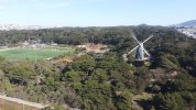
I didn't do that as the parking is only for patrons of the businesses there. So I headed up, drove up towards the top of Yerba Buena island. There weren't any construction workers around today but you can see they've regraded the area up there to build condos. There is a big paved parking lot open, near the top but you couldn't walk to the other side facing SF from there, at least I didn't even try.

So I headed back towards SF but about 1000 feet from the ramp to the bridge, I found plenty of room on the right side of the road so I pulled off.

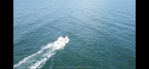
I flew from there. Air Map hadn't shown any NFZ but as soon as I opened the DJI Go app. it said I'm right on the border of the NFZ. So I took off, deciding that I would head northwards or north and west, towards SF. The NFZ seemed to extend from part of the YB island towards where the Coast Guard building was.

I took off and landed twice, had to guide the landing as the second time, my M2P tried to land closer to the road rather than the shoulder -- I had taken off right by the guard rails to the right of the road.

The most I got away was 2500-3000 feet and stayed just under 400 feet. A couple of times it flashed out of range warnings so I didn't push it. Basically I didn't even get half way across the Bay between YB Island and SF. I don't even think I got 1/3 of the way, since I didn't really fly directly west but more towards the north and west.

Still got the sun in some of the 180 and 360 panos. Video should look good, as it was a clear day, no clouds at all.

Then I headed towards the GG Bridge. Just as I was approaching it there were signs saying the Visitor Center was closed, 11/26 to 11/29. I went ahead anyways but when I reached the other side, it said Visitor Center there was closed as well.

I wasn't going to fly around the GG Bridge or the Headlands, just take regular pictures with my Nikon.

No big deal I figured, I wanted to go to the other side. Well at the offramp for Alexander Drive offramp, there were cars backing out to the right lane of the freeway. In both directions.

According to Google Maps, the closest parking to the Point Bonita Lighthouse was closed today and tomorrow and wouldn't open until 12:30 PM Sunday.

Just as well, it was already almost 3 PM and if I tried to reach those points, I'd be waiting another 30-60 minutes to get there and there might not be much light left.

I had a tripod but didn't want to wait so I'm going to have to try to get there another time.
 
Hello Thanks for posting your story. I hope at some point you upload the video? Do you know when you plan on coming back that way. Would like to meet up to fly with another Mavic Pliot. I was thinking of going back to Mersea restaurant area and flying around there. Hit me up Jeff
 
  • Like
Reactions: pelagic_one
Hello All

Wanting to know if anyone is flying this weekend coming up? if so hit me up. I'm needing some stick time. Jeff
 
Hello All

Wanting to know if anyone is flying this weekend coming up? if so hit me up. I'm needing some stick time. Jeff
Hey Guy — It’s a late reply, but a couple of us are riding eBikes along the SF waterfront tomorrow morning. We’ll also have MA2s in our backpacks, as we may fly around Fisherman’s Wharf.

eBikes and drones: Talk about Public Enemy #1 ? ?
 
I was stopped at Middle Harbor Park by a security guard as there’s apparently a No Drone rule, so I fly just north at the west end of Burma Road (37.8215619, -122.3204533). There are currently two inactive cruise ships that make for great flyovers.

I wish Middle Harbor Park was allowed - I live pretty much walking distance from there. Aside from the goose situation (bring an old pair of shoes...) it's very ideal.

There's a new park they just finished at the end of Burma Road. Good news is that means a parking lot and restrooms. Bad news is they have a no drone rule too, and there will likely be more people around now. (EBRPD - Judge John Sutter)

I'm new to this, not sure how dodgy it would be to park at that new park, then wander a bit east and find somewhere further down Burma to hang out. Prior to that park, it was absolutely vacant out there on the weekends.

I'm also curious/unsure about what is/isn't McLaughlin Eastshore State Park. Like the Emeryville side of that cove (around 37°50'13.2"N 122°18'10.4"W) seems like a nice spot, but I'm pretty sure that shoreline is all part of the state park. Not sure where that park ends and Toll Plaza beach starts.
 
Is there any info on flying in Vallejo/Benecia, specifically Lake Herman, the Ghost Fleet, or Mare Island(along Sears Point Rd)?

i know there’s been some chatter about the carquinez bridge area and the M.I. Shipyard.
 
I wish Middle Harbor Park was allowed - I live pretty much walking distance from there. Aside from the goose situation (bring an old pair of shoes...) it's very ideal.

There's a new park they just finished at the end of Burma Road. Good news is that means a parking lot and restrooms. Bad news is they have a no drone rule too, and there will likely be more people around now. (EBRPD - Judge John Sutter)

I'm new to this, not sure how dodgy it would be to park at that new park, then wander a bit east and find somewhere further down Burma to hang out. Prior to that park, it was absolutely vacant out there on the weekends.

I'm also curious/unsure about what is/isn't McLaughlin Eastshore State Park. Like the Emeryville side of that cove (around 37°50'13.2"N 122°18'10.4"W) seems like a nice spot, but I'm pretty sure that shoreline is all part of the state park. Not sure where that park ends and Toll Plaza beach starts.
The cul-de-sac at the end of Burma Road is okay for flying, since I’ve flown there with CHP and Oakland PD watching. As long as you don’t step into the park, you’re okay.

The Toll Plaza Beach has always been a fascination of mine, although I’ve never stopped there yet. I’d caution about all the radio broadcast towers, but when windsurfers are out there, it’s a tempting flight. The McGlaughlin Eastshore State Park ends around the point where you exit on Toll Plaza Kite to get to the Toll Plaza Beach, so it should be an okay area to fly.
 
  • Like
Reactions: MavicPeter
Is there any info on flying in Vallejo/Benecia, specifically Lake Herman, the Ghost Fleet, or Mare Island(along Sears Point Rd)?

i know there’s been some chatter about the carquinez bridge area and the M.I. Shipyard.
Absolutely, I flew around Lake Herman with a fellow forum member in July, with no known restrictions. The former Mare Island Naval Shipyard is still a great place to fly, especially on the north end towards Route 37 (on North Pier Street). The Ghost Fleet has been thinned down to only a few ships, and is still a fairly long flight from the nearest accessible spot on land, but a MA2 and M2P/Z (maybe Mini2) could get there.

Not mentioned here, but the Benicia Bridge Vista Point is also a good flying spot. There is a winding road up to it, with very little vehicular traffic. Views of the bridge, nearby train trestle, large arriving new car lot, and the Delta are highlights.
 
Last edited:
  • Like
Reactions: ReefDeep
The Toll Plaza Beach has always been a fascination of mine, although I’ve never stopped there yet. I’d caution about all the radio broadcast towers, but when windsurfers are out there, it’s a tempting flight. The McGlaughlin Eastshore State Park ends around the point where you exit on Toll Plaza Kite to get to the Toll Plaza Beach, so it should be an okay area to fly.

I've been studying the maps trying to figure this out, too. I can't tell if there's any way to get there either on foot or bike - does that place where the Bay Bridge trail u-turns under the eastbound lanes have a space where you could cross under the westbound lanes? (I'll have to check it out next weekend, maybe.)

And, touchy subject, but I'd also worry about any residents that live down there. Same reason I would love to fly by Raimondi park and get some footage of the 16th street station, but the Wood Street encampments would make this a bit touchy.
 
Lycus Tech Mavic Air 3 Case

DJI Drone Deals

New Threads

Forum statistics

Threads
131,116
Messages
1,559,989
Members
160,094
Latest member
odofi