DJI Mavic, Air and Mini Drones
Friendly, Helpful & Knowledgeable Community
Join Us Now

UPDATED! Studied, videos, My first flight/crash... and now I'm gun-shy to fly

Is this the correct order?

His pre-flight checklist was this:
  1. Controller on. Verify GPS on the controller, battery, etc.
  2. Drone battery on.
 
Is this the correct order?

His pre-flight checklist was this:
  1. Controller on. Verify GPS on the controller, battery, etc.
  2. Drone battery on.
Being that the GPS module is in the AC, not the RC, I dont see how you can check for GPS quality when the AC is off???
 
  • Like
Reactions: tleedom and sar104
Ok, so I believe the GPS was not calibrated... I turned on the drone today and noticed, HECK, the drone was showing a distance of around 17' away even though the controller was maybe 2.5 to 3' away. So, as a total newb I guess I blew it and didn't notice this anomaly.

After studying the CSV Verbose file I pasted the lat/long into Google Earth Pro for the first point in the file and right away the starting point was showing about 25' away from where the drone was actually sitting on my deck!

So this is what I think happened. Drone was placed on my deck... Drone thought it was about 25' away... I went straight up and came straight down - so far so good.

Then I wanted to "test" the RTH feature, as soon as I activated RTH it went straight over to where it thought it was (it did not go to max height) - it then hovered as it was doing a bit of weed eating on the tip of a branch - somewhere around this time there IS an "obstacle above" warning

maybe as soon as it moved over to a lower limb of the tree it detected more limbs above that and just stayed in place weed eating.

Then I forced it down and maybe at that time it became free to move "away" from the obstacle (towards my deck) I have no explanation why it then started flying toward my deck as if it thought it was already 25' away, why would it come back towards the deck?

maybe obstacle avoidance prevented it from flying into a dense circle of trees? subsequent Lat/Longs show the drone right in the middle of a circle of trees behind my house.

I kinda think the GPS or whatever determines where the drone "thinks" it is was totally out of calibration. I re-calibrated today (controller, IMU & Compass)and did a test flight in my front yard. it performed as expected EXCEPT I was too gun shy to try RTH again... I'll have to find a big vacant field before I have the guts to do it again...
 

Attachments

  • Lat long different from actual take off place.png
    Lat long different from actual take off place.png
    1.5 MB · Views: 60
Last edited:
You cant 'calibrate' the GPS. However a magnetically distorted take off point could upset the IMU/Compass. @sar104 will know more.
From what I see, the AC was responding well to your commands. You actually weren't straight above yourself, you had drifted out a bit, You seem to have brought it down ok, but when RTH was hit, the AC wanted to rise to 65 m, and then some rather quick and erratic finger movements got you a little confused perhaps? As I indicated, @sar104 or @Meta4 will shine more light on this, I could be totally wrong!!!!
Untitled.jpg
 
You cant 'calibrate' the GPS. However a magnetically distorted take off point could upset the IMU/Compass. @sar104 will know more.
From what I see, the AC was responding well to your commands. You actually weren't straight above yourself, you had drifted out a bit, You seem to have brought it down ok, but when RTH was hit, the AC wanted to rise to 65 m, and then some rather quick and erratic finger movements got you a little confused perhaps? As I indicated, @sar104 or @Meta4 will shine more light on this, I could be totally wrong!!!!
View attachment 65829
thanks for your interpretations...

I can promise you when I activated RTH I did not touch the controls/joysticks... it just started heading to the tree... after this, I could have been finger-happy trying to get it away from the tree and maybe land it below on the ground... it was moving like someone else had the controls.

doesn't it seem weird that the first set of lat/longs reported in CSV Verbose was clearly way out beyond the deck even though the drone was on my deck?
 
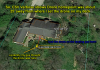
First problem I see is your choice of location.
It looks like there's a lot of potential for problems with so many trees so close.
You really need to go to a park or playing field to do your early flying.
Ok, so I believe the GPS was not calibrated
...
I kinda think the GPS or whatever determines where the drone "thinks" it is was totally out of calibration. I re-calibrated today (controller, IMU & Compass)and did a test flight in my front yard. it performed as expected EXCEPT I was too gun shy to try RTH again... I'll have to find a big vacant field before I have the guts to do it again...
There is no way to "calibrate" GPS and it never needs to be calibrated or adjusted.
You do need to fly from somewhere without trees or other obstacles blocking a big chunk of the GPS antenna's sky view.
Messing with the compass and IMU won't do anything to "fix" what you presumed to be a problem with GPS.
doesn't it seem weird that the first set of lat/longs reported in CSV Verbose was clearly way out beyond the deck even though the drone was on my deck?
Your GPS recognised that its original home point was recorded with less than perfect GPS conditions and updated with better information at 0:02.5.

You initiated RTH at 1:29.6 when the drone was 21 ft from home and 13 ft up.
Because it was within 20 metres of the home point, the drone turned to point home and commenced flying there.
I can promise you when I activated RTH I did not touch the controls/joysticks... it just started heading to the tree... after this, I could have been finger-happy trying to get it away from the tree and maybe land it below on the ground... it was moving like someone else had the controls.
While the drone was returning you were adding joystick input at 1:35, 1:37, 1:38.4, 1:41, 1:42.1 and 1:46.
The drone reached a point directly above the home point and started from 1:46.6.

While the drone was descending you fought it again at 1:47.5, 1:51.1 and 1:51.9.

Then I wanted to "test" the RTH feature, as soon as I activated RTH it went straight over to where it thought it was (it did not go to max height) - it then hovered as it was doing a bit of weed eating on the tip of a branch - somewhere around this time there IS an "obstacle above" warning
maybe as soon as it moved over to a lower limb of the tree it detected more limbs above that and just stayed in place weed eating.
What you describe as weed eating could upset the drone and cause erratic flight.
It's very hard to tell what's going on from the data.
Particularly when you get down to a level where the GPS reception is partially blocked by tree cover and becomes unreliable.

At around 1:48.9 there is evidence of a possible gentle collision and a larger one at 1:51.3.

From 1:49.3 at a height of 3.6 ft above launch point (but 9 ft above something detected by the VPS), the drone starts moving away from the home point and reached 7 mph and ends up 20 feet away.
However these numbers cannot be relied on with GPS reception affected by tree cover.

I have no explanation why it then started flying toward my deck as if it thought it was already 25' away, why would it come back towards the deck?
maybe obstacle avoidance prevented it from flying into a dense circle of trees? subsequent Lat/Longs show the drone right in the middle of a circle of trees behind my house.
As mentioned above you were in dodgy GPS conditions and the numbers/position data are likely to be inaccurate.

Get out in the open and do your learning flights in a safe area.
 
Thanks for the feedback.


So I knew the location was not the best but this is why I flew straight up and straight back down. My intention was to never fly horizontally and take a chance of collision. Only AFTER the Drone flew away from the verticle path did I start trying to manipulate controls. If it would have been properly calibrated it should have merely gone straight back up and then descended once RTH was engaged. For a specific flight path planned to go straight up and then land does not seem like a cavelier or overly risky attempt.
I still maintain a calibration or malfunction had occurred before take off ever occurred.
 
So I knew the location was not the best but this is why I flew straight up and straight back down. ... For a specific flight path planned to go straight up and then land does not seem like a cavelier or overly risky attempt.
A lack of flying knowledge and experience has given you a false sense of safety.
You just aren't aware of a number of issues that could cause problems that you don't even imagine in that environment.
Just take my advice and find a large, open area and you'll fly a lot safer.

I still maintain a calibration or malfunction had occurred before take off ever occurred.
You do but that's coming from a position of not understanding the issues you had to deal with in that location.
One more time ... There is no such thing as GPS calibration.
Yours would be truly unusual if it was not working properly.
However the location you were using it in is highly likely to give inaccuracy down where tree cover is interfering with reception.
I already explained this above.
Combine inaccurate position/speed information with an area full of tree branches and you are just asking for trouble.
 
So, I bought a used (uncrashed) M2Z with flymore and other accessories about 10 days ago. I resisted the urge to put on my "cowboy hat" and wing it (i know - poor pun) but instead, I watched many "how to" YT vids on how to fly the zoom. Read many articles about it... I paid attention to many settings - I followed along with a "primer" on all the settings to "your first flight."

And then you chose to take your first flight in a totally unsuitable location with only a few meters of clearance from multiple obstacles (trees, buildings etc.) and a poor view of the sky?

The home point was recorded at around 2 s, but was around 6 m south of the takeoff location - your deck:

1552483102876.jpeg

Viewed graphically, you can see that as the aircraft ascended the GPS location was corrected, but the home point was still at the original recorded location.

Graph4.png

I'm not sure why the aircraft didn't simply land on RTH, since it was within the threshold distance of the home point but, either way, this should be a lesson on the accuracy of GPS with limited sky view and on the inadvisability of launching and using automated flight in such a restricted space.
 
  • Like
Reactions: Elude
You can purchase and replace it. I have done many, but you might need to purchase a whole arm just to get the landing leg off of it.

I tried to buy one from the DJI Store and the said it was only available if I sent it in for repair. I could even get the whole leg. I have less damage but would like to fix the leg.
 
  • Like
Reactions: Former Member
I tried to buy one from the DJI Store and the said it was only available if I sent it in for repair. I could even get the whole leg. I have less damage but would like to fix the leg.

Yes, DJI only sells parts to authorized repair facilities, and even then, they only sell the whole arm.

You can buy a whole arm many places online.
 
Meta4 said:
Your drone will automatically set a home point as soon as it gets a good GPS location.

If you launched before a home position is set, it will still set a home point as soon as it gets a good GPS location, and that is going to be fairly close to the launch point.
I spent some time RTFM last night before I get my drone, and on page 15 it specifically addresses the "Home" function - and it says this about "Home" ...
In all of the 55 mentions of "Home" in the manual, it never says anything about auto-updating Home once the drone is in flight, and Home is a very important theme for the drones automated systems. Important enough that you probably shouldn't launch without it. Are you certain it'll automatically acquire a new Home while in flight if one wasn't available at launch? A test might require launching from a tinfoil covered box or something so the drone can acquire GPS after launch, but can't get it before launch.

It is good to know you've done some research with it to find out that the previous Home is wiped; kind of a relief to know my drone won't try to fly back to where ever it got it's last good Home reading from GPS.

I do plan to email them and ask them to amend their course teachings, but his position maybe isn't a bad one for a "beginner" flight class; it's just not entirely accurate. Looking for a good GPS return can help keep you from flying without a Home point, which many beginners may rely on as a safety net.

The instructor has been flying drones for years and may simply not have been aware of the systems being updated if he kept doing his routine every flight, he wouldn't have ever noticed a difference.

Being that the GPS module is in the AC, not the RC, I dont see how you can check for GPS quality when the AC is off???
I think the DJI GO 4 software provides you with the option to create a new Home on the fly by saying "Home is where the Controller is" (assuming GPS on the RC - or maybe using the attached phone's GPS) or "Home is where you are right now" (using the AC's GPS).

I've been looking for an answer to that this morning, and the best I've seen is a reference to the software possibly tapping into a phone's GPS to establish that.

I promise I'm not trying to be a know-it-all. I haven't even held my drone yet, let alone flown it. I am, however, trying to learn as much as I can about the systems involved before I ever launch. If it seems like I'm challenging answers or speaking in ignorance, it's not intentional.
 
Last edited:
  • Like
Reactions: JakeRobinson
And then you chose to take your first flight in a totally unsuitable location with only a few meters of clearance from multiple obstacles (trees, buildings etc.) and a poor view of the sky?

The home point was recorded at around 2 s, but was around 6 m south of the takeoff location - your deck:

View attachment 65854

Viewed graphically, you can see that as the aircraft ascended the GPS location was corrected, but the home point was still at the original recorded location.

View attachment 65853

I'm not sure why the aircraft didn't simply land on RTH, since it was within the threshold distance of the home point but, either way, this should be a lesson on the accuracy of GPS with limited sky view and on the inadvisability of launching and using automated flight in such a restricted space.


I get that you think it was an unsuitable location because there was a tree that might be nearby. But if my intended flight path was straight up and straight down and it was open straight up and straight down and I set the home point to where the Drone was sitting on the landing pad, how could it not Ascend and descend exactly where it came from. Or other words, how did the home Point wind up being 20 m south of my deck?
 
I get that you think it was an unsuitable location because there was a tree that might be nearby. But if my intended flight path was straight up and straight down and it was open straight up and straight down and I set the home point to where the Drone was sitting on the landing pad, how could it not Ascend and descend exactly where it came from. Or other words, how did the home Point wind up being 20 m south of my deck?

I explained that quite clearly in post #30. The home point was set with an inaccurate GPS position fix - probably because of the poor sky view. And it was 6 m south of the deck, not 20 m.
 
  • Like
Reactions: JakeRobinson
A lack of flying knowledge and experience has given you a false sense of safety.
You just aren't aware of a number of issues that could cause problems that you don't even imagine in that environment.
Just take my advice and find a large, open area and you'll fly a lot safer.


You do but that's coming from a position of not understanding the issues you had to deal with in that location.
One more time ... There is no such thing as GPS calibration.
Yours would be truly unusual if it was not working properly.
However the location you were using it in is highly likely to give inaccuracy down where tree cover is interfering with reception.
I already explained this above.
Combine inaccurate position/speed information with an area full of tree branches and you are just asking for trouble.

And my last reply that you quoted I did maintain there must be some calibration that was not properly done, did not include GPS since that is a incorrect assumption. But there are other calibrations, no? Could compass calibration or IMU calibration if it's not done properly or not done at all affect the home point?

I'm just trying to figure out why the ac thought it was 20' south where actually was when I set the home point before takeoff? Are you saying that GPS is that inaccurate? BTW, the photo used is a Google earth but in real time there were no leaves on the tree, don't know if that would make a difference.

Yes - initial GPS position fix with poor sky view can easily be 6 m off. The home point is simply a GPS-derived position - it has nothing to do with the compass or IMU.
 
I guess I would never hit return to home in my backyard. Just seems too constrained by house and trees and whatnot. What is not obvious is there is even another small apple tree right in the middle between the house and that gray landing pad. I only land it manually. I've only practiced RTH and Precision Landing at a wide open soccer field.

Backyard.jpg
 
I explained that quite clearly in post #30. The home point was set with an inaccurate GPS position fix - probably because of the poor sky view. And it was 6 m south of the deck, not 20 m.


My bad on 20m - meant 20'

How do you determine if GPS has a good fix or not - does it show how many satellites are active? I thought there was around 18.

Btw, I'm not challenging your expertise, I'm just not understanding the logic as I am new. So follow up questions are to clarify what you're saying and what I'm understanding
Yes - initial GPS position fix with poor sky view can easily be 6 m off. The home point is simply a GPS-derived position - it has nothing to do with the compass or IMU.

thank you! that clears it up as I did not realize that... cheers
 
I guess I would never hit return to home in my backyard. Just seems too constrained by house and trees and whatnot. What is not obvious is there is even another small apple tree right in the middle between the house and that gray landing pad. I only land it manually. I've only practiced RTH and Precision Landing at a wide open soccer field.

View attachment 65977

So, most likely if I had skipped RTH and just manually landed I would have been fine... glad to know RTH is best used with wide open area...
 
Lycus Tech Mavic Air 3 Case

DJI Drone Deals

New Threads

Forum statistics

Threads
130,976
Messages
1,558,503
Members
159,965
Latest member
ozwaldcore