


You are using an out of date browser. It may not display this or other websites correctly.
You should upgrade or use an alternative browser.
You should upgrade or use an alternative browser.
WHAT IS THE MAXIMUM HEIGHT FOR MAVIC 2
- Thread starter E90RAW
- Start date

WithTheBirds
Well-Known Member
- Joined
- Sep 2, 2018
- Messages
- 2,560
- Reactions
- 1,601
Understood. Notwithstanding, and you might agree- the forums are read by many who don’t comment. To the extent what is said here, and potentially relied on as fact, might cause unexpected and potentially adverse outcomes- clarification is often important.
jagraphics
Well-Known Member
Maximum ascent speed in sport mode is 5 m/s. With that maximum, and at the power consumption rate of a fast climb which will only give around 10 minutes of battery life, that's going to get you up to around 3000 meters. Down is going to be free fall however.
Al the videos I have seen of M2's show just over 8,200 feet (2,500 Meters) from sea level and only just having a safe return. So 3000 meters (9,800 feet) might be pushing it a bit. It would certainly be in free fall on the way down.
This is *IF* you could keep control of the drone on the way up to get that high. At 8,200 feet it was complaining of weak signal and the operator was ignoring RTH. So much higher and the drone would loos contaxct with controller and RTH anyway.
With a fully hacked flight control SW to remove RTH and all other warnings then 3000 meters from Sea level *might* be possible but only on a open way flight. I wonder where DJI got the reported 19,000 feet from?
WithTheBirds
Well-Known Member
- Joined
- Sep 2, 2018
- Messages
- 2,560
- Reactions
- 1,601
From a location at 17360 feet- 500m (1640ft) below 19000.Al the videos I have seen of M2's show just over 8,200 feet (2,500 Meters) from sea level and only just having a safe return. So 3000 meters (9,800 feet) might be pushing it a bit. It would certainly be in free fall on the way down.
This is *IF* you could keep control of the drone on the way up to get that high. At 8,200 feet it was complaining of weak signal and the operator was ignoring RTH. So much higher and the drone would loos contaxct with controller and RTH anyway.
With a fully hacked flight control SW to remove RTH and all other warnings then 3000 meters from Sea level *might* be possible but only on a open way flight. I wonder where DJI got the reported 19,000 feet from?
19,000 ft is simply the engineered upper limit of where the propulsion system can produce sufficient thrust. It is a simple matter of air density.
jagraphics
Well-Known Member
19,000 ft is simply the engineered upper limit of where the propulsion system can produce sufficient thrust. It is a simple matter of air density.
That as you say would depend on air density... also humidity, temperature etc so in perfect humidity and air density a theoretical maximum is 19,000
There is absolutely no way any M2 could get anywhere near that other than in a 19,000 foot sealed tube.
Reality seems to be less than 9,000 feet even with all the flight control SW hacked.
DJI doesn't claim that the aircraft can climb 19,000 ft - you are confusing climb with operating ceiling. 19,000 ft AMSL is the specified maximum altitude at which the aircraft can operate - i.e. if you try to take off above that altitude it will suffer significant performance degradation due to lack of lift.
hello Saigondroner can you please check your private message i need your respondSix clix...roger roger, what's the vector victor, clearance clarence?
Out
29k ft exceeds service ceiling. If it does manage to fly, it won't do so very well.They will if you climb most of the way!!
:-D
I measured mine and max height is about 3.2 inches ")

SxSmith
Active Member
I'm pretty sure none of the Mavics will fly at the top of Mt Everest.
I measured mine and max height is about 3.2 inches
Surely not if it is standing up on its rear legs.
My two cent contribution...
I flew my Mavic Pro twice above the Cerro Estrella, an abandoned sulfur mine located right on the border between Chile and Argentina. (Coordinates: 25° 05' 55.81" S, 68° 21' 23.59" W)
The top of the mountain is reported to be either 5,475 or 5,400 meters above sea level, depending on two different sources.
The take-off point is at 5,225 meters, where the barracks of the miners were built.
The first time (January 3, 2018) I took it around 25-30 meters above the top , i.e. at 5,500 meters at best.
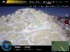
The second time (January 7, 2020) I did a bit better, flying it 449 meters above the take-off point, i.e. reaching around 5,674 meters, well above the top of the peak. (see picture 1)
Both times I was extremely lucky with the wind, that usually blows up to 100 km/h all the afternoons: in my two the late morning's visits II had it at no more than 20-30 km/h, allowing a pretty smooth flight.
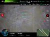
My standard Mavic Pro flies with standard blades; no overheating of the motors was reported at the end of the flight, is spite of numerous "Max Motor Speed Reached" alarms appeared during the ascending phase of the second flight, this year. (see picture 2)
This year I must report numerous signal losses, with unwanted and fast 360° panoramic shots (in spite of a usually very stable connection between my RC/iPad Mini and the bird) and several problems with the focus, that was set on Auto. But I do not believe that both events are caused by altitude.
It's surely not an altitude record for a Mavic Pro, but I believe it's close... and a repeat! ;-)
By the way, my Mavic Pro entered in two high-altitude volcanoes, this year. An interesting experience!
and
I flew my Mavic Pro twice above the Cerro Estrella, an abandoned sulfur mine located right on the border between Chile and Argentina. (Coordinates: 25° 05' 55.81" S, 68° 21' 23.59" W)
The top of the mountain is reported to be either 5,475 or 5,400 meters above sea level, depending on two different sources.
The take-off point is at 5,225 meters, where the barracks of the miners were built.
The first time (January 3, 2018) I took it around 25-30 meters above the top , i.e. at 5,500 meters at best.
The second time (January 7, 2020) I did a bit better, flying it 449 meters above the take-off point, i.e. reaching around 5,674 meters, well above the top of the peak. (see picture 1)
Both times I was extremely lucky with the wind, that usually blows up to 100 km/h all the afternoons: in my two the late morning's visits II had it at no more than 20-30 km/h, allowing a pretty smooth flight.
My standard Mavic Pro flies with standard blades; no overheating of the motors was reported at the end of the flight, is spite of numerous "Max Motor Speed Reached" alarms appeared during the ascending phase of the second flight, this year. (see picture 2)
This year I must report numerous signal losses, with unwanted and fast 360° panoramic shots (in spite of a usually very stable connection between my RC/iPad Mini and the bird) and several problems with the focus, that was set on Auto. But I do not believe that both events are caused by altitude.
It's surely not an altitude record for a Mavic Pro, but I believe it's close... and a repeat! ;-)
By the way, my Mavic Pro entered in two high-altitude volcanoes, this year. An interesting experience!
and
Attachments
Last edited:
HoozierDroneDaddy
Well-Known Member
- Joined
- Mar 12, 2017
- Messages
- 1,085
- Reactions
- 768
- Age
- 73
My solution with my M2P was selecting a distant point higher up that was tilted toward me that allowed direct line of sight and no degradation in signal strength... checked this at hover over said location. Then landed, wait about 20-30 seconds, but DO NOT POWER OFF ANYTHING. After 20-30 seconds I could TO with the landing point registerred as a new zero altitude. Used this trick to see over the top of Santan Mtn.
Of course that landing is edited out, but it got me above the 2000’ summit.
Flying the Santan Mountains
I look at this part of the Santan Mountains while sitting on my back porch as I only live about 3 miles away in south Gilbert, AZ. I always wanted to explore the peak with my M2P... Well, I ended up having about 8 hours of video to edit. It was taken on several different days over about 2...mavicpilots.com
I saw this technique used in a video overseas where they flew to the top of a skyscraper, landed on the roof to reset to zero altitude, then continue flying to an extreme height on a higher building that would not have been able to be achieved otherwise.
DJI DelBoy
Well-Known Member
- Joined
- Jan 21, 2018
- Messages
- 137
- Reactions
- 20
- Age
- 44
Have you got a link to that video?I saw this technique used in a video overseas where they flew to the top of a skyscraper, landed on the roof to reset to zero altitude, then continue flying to an extreme height on a higher building that would not have been able to be achieved otherwise.
HoozierDroneDaddy
Well-Known Member
- Joined
- Mar 12, 2017
- Messages
- 1,085
- Reactions
- 768
- Age
- 73
Have you got a link to that video?
I will have to look, it was over a year ago. Don't remember the name of the city or tower. If I find it I will post it here.
Umgapa Sky
Member

Captain Winkie
Member
Yeah there are bound to be very strong winds near the summit of that mountain and you're drone will be really unstable and maybe even crash into the mountain. I wouldn't take that risk.My Mavic 2 Pro limits at 500m. Is there any way to make it go higher as I live right next to 10,500' mountains in the foothills at 6,300'. I met a flyer that uses nolimitdronez.com to reset the limits but it is not available for the Mavic 2 Pro. I just want to fly to the top close to the mountain. Is there any way to boost the 500m limit?
The higher you go, the stronger the winds get in most situations i believe so its north worth it going that high. I'd maybe take a drone to 1000m and that's it.
Mavic2MarkNM
Member
- Joined
- Nov 4, 2018
- Messages
- 7
- Reactions
- 2
- Age
- 65
Yeah there are bound to be very strong winds near the summit of that mountain and you're drone will be really unstable and maybe even crash into the mountain. I wouldn't take that risk.
The higher you go, the stronger the winds get in most situations i believe so its north worth it going that high. I'd maybe take a drone to 1000m and that's it.
Well this guy was able to go that high with the Phantom. I have driven to the top of the mountain and flown along the cliffs and that is a fun way to fly and fly down towards the cliffs that is safe distance even in Highwinds with the Mavic two. At least you can not get too far away and still enjoy the views along the edges.
Mavic2MarkNM
Member
- Joined
- Nov 4, 2018
- Messages
- 7
- Reactions
- 2
- Age
- 65
My solution with my M2P was selecting a distant point higher up that was tilted toward me that allowed direct line of sight and no degradation in signal strength... checked this at hover over said location. Then landed, wait about 20-30 seconds, but DO NOT POWER OFF ANYTHING. After 20-30 seconds I could TO with the landing point registerred as a new zero altitude. Used this trick to see over the top of Santan Mtn.
Of course that landing is edited out, but it got me above the 2000’ summit.
Flying the Santan Mountains
I look at this part of the Santan Mountains while sitting on my back porch as I only live about 3 miles away in south Gilbert, AZ. I always wanted to explore the peak with my M2P... Well, I ended up having about 8 hours of video to edit. It was taken on several different days over about 2...
Great idea thank you I will give it a try. Maybe I could land on that big boulder up there and reset it from there; the one near the tram
Similar threads
- Replies
- 1
- Views
- 1K
- Replies
- 21
- Views
- 3K


DJI Drone Deals
New Threads
-
-
-
RC 2 Controller Firmware: v08.00.0000 Mini 4 or v08.01.0100 Mini 5
- Started by Calson
- Replies: 0
-
-
Forum statistics
