DJI Mavic, Air and Mini Drones
Friendly, Helpful & Knowledgeable Community
Join Us Now

Why did my Air 2 S decide not to come home to Papa?

al
It can, as long as it has signal and you haven't put it in conditions that prevent it like here.


It won't "flyaway", as mentioned as long as it's possible it'll return home if signal is lost.
ok so can we review how one can prevent an issue with GPS flyaway for Air2s?
1) incorrect altitude setting.
2) lost GPS signal. ( How often does that occur and how can that be avoided?

anything else? t
 
  • Like
Reactions: gwc
Good thread this, lots to learn in it.

There is one thing that may or may not have helped here, I am not certain if the Air 2s has this behaviour but with the likes of the Mavic Mini there is a section of the manual that reads,

"It is important to set a suitable RTH altitude before each flight. Launch DJI Fly, and then set the
RTH altitude. In Smart RTH and Low Battery RTH, the aircraft automatically ascends to the RTH
altitude. If the aircraft is at an altitude of 65 ft (20 m) or higher and has not yet reached the RTH
altitude, the throttle stick can be moved to stop the aircraft from ascending.
The aircraft will fly
directly to the Home Point at its current altitude."

I have not yet been able to find a similar section in the Air 2S manual so it may not have this behaviour.

If you look at the following chart is shows the flight mode (as shaded areas), the height as the green line and the throttle as the purple line. During all the RTH climbs you gave no thottle command.

I did not show the response to the elevator and it was barely moving, I guess butting up against the air corridor that Kilrah mentioned.
 

Attachments

  • Untitled.png
    Untitled.png
    112.7 KB · Views: 5
  • Like
Reactions: Mantrain
But what is the realistic range?

VLOS = Visual Line Of Sight.

About a half a mile depending on the size of the aircraft.

Which means you are to keep your aircraft within your eyesight and be able to tell the orientation of it, regardless of how far it can go.

A Visual Observer can aid with this.
 
  • Like
Reactions: BigAl07
Last edited:
  • Like
Reactions: iglou7

@Mantrain, be aware that the altitudes in that chart are the maximums only if you have LAANC approval to fly there. Without the LAANC approval, flying there is totally prohibited.

You need to check out your local area and understand what's there that you need to avoid - airports, military facilities, prohibited areas, ... As you've discovered, you can't rely on the drone to keep you out of trouble. As the pilot in command, that's totally your responsibility.

Here's a basic resource on airspace types.

Check into the FAA TRUST certificate, too. Recreational drone operators are required by federal law to have it. It's a good review of basic regulations, safety, and good practices. You can complete it online at no cost.

FAA details - https://www.faa.gov/uas/recreational_fliers/knowledge_test_updates/
Pilot Institute summary - https://www.faa.gov/uas/recreational_fliers/knowledge_test_updates/

I had a flight instructor who said that all new pilots soon get a little too confident, and eventually have something that scares the daylights out of them. If it doesn't kill them, they get serious and become much better pilots. It sounds like you're there, without too much fuss. Good luck, and have fun.
 
Also if I lose site of the Air2s will I chance lose control? I thought not since they say the range is like 11km or so.

But what is the realistic range? Will I get a flyaway after say mile 2 in actuality? I thought that the GPS could always RTN even in lost visual.

edit

also thank you all for helping me out. I know I was a bit bravado I just got really excited about this powerful new drone. I was previously flying a Limitless 3 which is so not as nice.

I purchased a premium account so I can take the course and learn how not to lose my drone like my previous wives.

Welcome to the forum.

I'm glad you found this place, and looks like you're keen to stick around, as you WILL learn to operate your A2S properly, to get it home each flight (99.9% not withstanding unusual events), and how to operate the drone safely.

I'd suggest, download (if not already) and read the A2S manual back to front, maybe follow up that again at a park, open flat daylight, and test a few things like RTH, general flight etc.

Read up here, the A2S section, general section, and the crash section, soak it up.

Also go to YouTube, search > DJI Ari2s first flight < and watch some of those.

The more you learn in a safe environment, before taking such riskier flights, the better all round for safe and repeated operations.

Again, welcome, and enjoy the A2S, you've been handed a second chance to keep / fly it.
 
  • Like
Reactions: Mantrain
So it seems to be that this max RTN altitude could be used as an exploit for unscrupulous users to get as high as they want (drug free). Just set at whatever height then take control away from the RTN when it reaches the height.
 
Why do you keep refering to RTN?
There is a maximium height hard wired in, 500m, you had that set, unless the drone's firmware is hacked that can't be broken unless, possibly, you mess with the barometer.
 
So it seems to be that this max RTN altitude could be used as an exploit for unscrupulous users to get as high as they want (drug free). Just set at whatever height then take control away from the RTN when it reaches the height.
No...
As it looks it climbed because you were just outside the zone at that time, if you had been inside it wouldn't have. Once it had climbed it was stuck behind.
 
Last edited:
ok something also strange happened I did not want to mention but I was very close to home
No...
As it looks it climbed because you were just outside the zone at that time, if you had been inside it wouldn't have. Once it had climbed it was stuck behind.
it climbs to the specified height in the RTN setting even if it is 500 meters so that appears like an exploit. It will pretty much do this in any zone I think. There is this mountain up the street, this highest in City of San Diego its like 1200 feet. Theoretically I could get it there to the top of where people hike by getting it nearby and hitting RTN, assuming the RTN is set to 1200 feet. Then one could cancel the RTN. I am sure this will be eliminated in an update or maybe it is and I need to update.


edit
the mountain in question is nearly 1600 feet high but from where I live very nearby I am already 300 feet high.
 
Last edited:
ok something also strange happened I did not want to mention but I was very close to home

it climbs to the specified height in the RTN setting even if it is 500 meters so that appears like an exploit. It will pretty much do this in any zone I think.
I don't think you understand the aircraft settings. You can select up to 500 m (1640 ft) as the maximum height above the takeoff point, and that is what yours was set to. You can then fly it up to that height without needing any trickery or exploits involving RTH (BTW it's RTH - not RTN), unless you are in a DJI altitude zone or restricted zone, in which case you cannot get there by any method.
There is this mountain up the street, this highest in City of San Diego its like 1200 feet. Theoretically I could get it there to the top of where people hike by getting it nearby and hitting RTN, assuming the RTN is set to 1200 feet. Then one could cancel the RTN.
It is legal to fly up to 400 ft above ground level in uncontrolled airspace, or to lower heights AGL in controlled airspace as specified in the LAANC maps. It doesn't matter if the ground is much higher than the takeoff point either. In your example you can legally fly up that hill, as long as you maintain VLOS of course, and you can achieve it with the Air because it would not need to exceed 1640 ft above the takeoff point.
I am sure this will be eliminated in an update or maybe it is and I need to update.

edit
the mountain in question is nearly 1600 feet high but from where I live very nearby I am already 300 feet high.
No - it won't be eliminated because that is how it is supposed to work, and always has worked.

You really need to learn (1) how your aircraft works and (2) the regulations covering the use of drones. Right now you sound like a menace in the airspace.
 
I don't think you understand the aircraft settings. You can select up to 500 m (1640 ft) as the maximum height above the takeoff point, and that is what yours was set to. You can then fly it up to that height without needing any trickery or exploits involving RTH (BTW it's RTH - not RTN), unless you are in a DJI altitude zone or restricted zone, in which case you cannot get there by any method.

It is legal to fly up to 400 ft above ground level in uncontrolled airspace, or to lower heights AGL in controlled airspace as specified in the LAANC maps. It doesn't matter if the ground is much higher than the takeoff point either. In your example you can legally fly up that hill, as long as you maintain VLOS of course, and you can achieve it with the Air because it would not need to exceed 1640 ft above the takeoff point.

No - it won't be eliminated because that is how it is supposed to work, and always has worked.

You really need to learn (1) how your aircraft works and (2) the regulations covering the use of drones. Right now you sound like a menace in the airspace.
I know I do need to learn. Wished it would have come with a manual. I do see the manual for the 2 AIR S I am downloading's now but I also need a manual for the Fly app.

A lot to learn.

But i would like to clarify something:

So the maximum legal ascent if 400 feet right? From wherever the take off is.

If I am standing at the bottom of a hiking trail, which leads up the mountain at 1600 feet ( I am standing at 300 feet already) then there is no way I am legally flying my drone to the top of the mountain. I would have to walk it up to the top of the mountain, minus 400 feet I would have to walk it up to 1200 feet to fly the remainder of the 400 feet, right?

However I could set the maximum limits and fly the drone up to the top, but that is breaking the rules and making it bad for everyone, I assume, right?
 
also if anyone can recommend some good reading on this topic of learning drones I would be much obliged.
 
I know I do need to learn. Wished it would have come with a manual. I do see the manual for the 2 AIR S I am downloading's now but I also need a manual for the Fly app.

A lot to learn.

But i would like to clarify something:

So the maximum legal ascent if 400 feet right? From wherever the take off is.

If I am standing at the bottom of a hiking trail, which leads up the mountain at 1600 feet ( I am standing at 300 feet already) then there is no way I am legally flying my drone to the top of the mountain. I would have to walk it up to the top of the mountain, minus 400 feet I would have to walk it up to 1200 feet to fly the remainder of the 400 feet, right?

However I could set the maximum limits and fly the drone up to the top, but that is breaking the rules and making it bad for everyone, I assume, right?
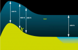
No - that is incorrect. I don't know how to explain it any more simply. There is no limit to how far you can fly above the takeoff point provided that you stay within 400 ft of the ground below the aircraft.

Perhaps a simple graphic will help:

1638153516419.png
 
  • Like
Reactions: Phantomrain.org
Ohhh really????? I did not catch that....

so my drone can climb that mountain trail...

Then the key is the approach because of there is a very steep grade the drone won't make it . Must approach from the lower grades to the higher grades.
 
Another thing:

So I presume the drone uses a barometer.

here is another question then, if someone does not mind indulging me:

I am interested in imaging my friends who are surfers but I am trying to contemplate the proper elevation to set the drone to, to be safe and not go in the drink, but not too high either so as not to lose detail.

The beach I go to has a nice lawn area actually, which overlook the beach by about 15 feet maybe +-.

I launch the drone from the parking lot or the lawn area, it goes up 10 feet so now I am 25 feet above sea level. But as I approach the shoreline I really have trouble knowing what my true elevation is. am I getting an accurate reading from the barometer? IE, the Fly App is not telling me what the elevation is from home, but from wherever the drone is currently? Because the cheaper drone I had before I think it just gave me the elevation from home so I really never knew what the elevation was.

What might be a good elevation to image surfers from on or near the shoreline in non-turbulent conditions or conditions that are not very turbulent? My camera is a 1" CMOS but no zoom so the closer the better.

I really appreciate any advise.

I lost my cheaper drone in the drink but that was because it was cheap and the battery they gave me clonkled out literally just dropping the drone into the ocean so I am leery about ocean imaging at the same time it is an important endeavor of mine.
 
Ohhh really????? I did not catch that....

so my drone can climb that mountain trail...

Then the key is the approach because of there is a very steep grade the drone won't make it . Must approach from the lower grades to the higher grades.

confused.gif
 
A lot to learn.

Bingo !
Didn't we all at one time :)

You found the manual, most of the flight issues like setting RTH for best effect, max alt you can go (up a mountain side etc), basic stuff.

The FAA drone rules, a good start for legalities, flight rules, done rego, TRUST cert, etc.

https://www.faa.gov/uas/recreational_fliers/

Mostly though reading here will probably set off some lightbulb moments, as too getting the right start with YouTube tutorials as I mentioned previously, that search for your aircraft model and first flight will be most helpful.
I just read about failsafe RTH.

But again the scenario re this OP invalidated the failsafe RTH. I doubt it is in the manual that if the smart RTH is activated but the drone is sent to an elevation in the RTH command which is too high, failsafe RTH fails and the user better know to manually bring the drone down to where it should be. I just got lucky. I was able to pilot the drone in the last few seconds into an empty parking lot where no one was.

So failsafe RTH is not always failsafe. but that is okay if I know how to manually get the drone where it needs to go. Had I known last night I would have had pleny a time to get it home.

A little more information about today though:
I wanted to see if I could approach the top of the mountain where I live which is a most popular hiking spot at just under 1600 feet elevation it is the highest spot in City of San Diego. I live very close by.

I set the RTN max alt to 1600 feet.

I flew my drone within the vicinity of the mountain base, and activated RTN.
The drone climbed to 1600 feet and after I canceled it, I flew around a bit out there seeing if I could approach the mountain top where everyone goes. At some point after a minute or so I lost the ability to pilot the drone about except to bring it down, which I did for a while.

Something again ascary happened.

For a very long handful of seconds I LOST ALL CONTACT with said drone. I had not yet purchased my flyaway coverage ( I since have.)

The display on my flight app literally read "lost contact."

For all I knew the drone exploded in mid air.

Or, just lost contact w GPS and cellular.

thankfully this incident was very short-lived and in a few moments all the live flight data feed was again restored and I resumed my shenanegans and brought her home. I then purchased the 2 yr flyaway coverage as I only had about 24 hours remaining to do so.
 
Lycus Tech Mavic Air 3 Case

DJI Drone Deals

New Threads

Forum statistics

Threads
131,096
Messages
1,559,801
Members
160,079
Latest member
calezu