DJI Mavic, Air and Mini Drones
Friendly, Helpful & Knowledgeable Community
Join Us Now

3 Week Old Mavic 2 Pro Flew Away seconds after take off

I had a fly away in a small-ish gust and I grabbed the kids and hopped in my car and followed it via the map on my controller (while it was still in the air). I found the drone landed next to a tree 3 miles away.
If you fly in a wind so strong that it blows the drone 3 miles away, that's not a "flyaway".
That's you giving your drone away to the wind.
 
Wow, that's some detective work in this thread!! I hope you find your drone, man. I had a fly away in a small-ish gust and I grabbed the kids and hopped in my car and followed it via the map on my controller (while it was still in the air). I found the drone landed next to a tree 3 miles away. I was about 1/4 mile ahead of me the whole time. It took about 12-15 minute for it to land/crash and run out of juice.
I’ll never forget the time I decided to goof with waypoints on my M2 Pro and SMART controller.
I set it all up, then clicked go.
The drone took off, and soon, I lost radio contact.
I wasn’t sure what was going to happen, and after a few min, I was running to the car to head in the direction of the flight.
While all this was going on, I got some message in red, telling me something about a line of sight violation!
Just as I was getting in the car, the drone signal came back.
I stood there by my car, and watched as it came back and landed.
I learned a lot that day, and have never used waypoints again, LOL!!!
 
  • Like
Reactions: McGanksta
That’s a new one……….anyone else?
In my rush, I didn’t focus on it too much, but I do clearly remember it said line of sight violation.
In the middle of everything else going on, I thought to myself, “Great!”
Nothing ever came of it, so I have no idea what was going on.
I was using a SMART controller, with a M2 Pro.
 
Sar104.... Your cape is showing.


Very nice.
Actually it is just the difference between the flight track produced by AirData vs. PhantomHelp. The AirData track is slightly truncated for some reason, and the final recorded position at 19.3 s elapsed time is over the building. There are no obvious deviations in pitch or roll up to that point, which probably rules out the tree.

View attachment 135385

It was in a gradual descent, and appears to have been heading directly at the antennas on that building:

View attachment 135386

The telemetry latency is a few tenths of a second, so that would be about right. I doubt it went much further than that but if it's not there then I'd look at the buildings across the street:

View attachment 135387
Sar104.... Your cape is showing.


Very nice.
 
  • Like
Reactions: sar104
Iid like to say well done to the ones that narrowed it down to the building and then the tree. Makes sense enough that if the OP doesn't find his drone in the tree after looking on top of the circled building,I wouldn't rule out the possibility that someone else found it by now and took it with them. Of course I hope the OP gets back his drone but I think the smart and experienced people on this forum have it narrowed down quite nicely so I would definitely go over every inch of that tree and surrounding area before I called in for the replacement.

Good luck,let us know how it turns out!
 
  • Like
Reactions: Bradders71
I have never needed help like this from this "team" of experts but it is so nice to read the thread of analysis by them. It is beyond my comprehension, that flight data, so thankful there are those who can analyze it so well.

As far as flying in a metro area, there are so many ways to get interference. When I am in Houston there are huge power stations even in small neighborhoods. Where there are tall buildings, just imagine the number of WiFi signals bouncing around, dozens from every floor of a high rise building.

Just in my small rural town, I once took off from a concrete parking lot just for some perspective near our water tower and my Mavic Pro went bonkers, went into atti mode. I had to fly it back manually to the first place I could put it down. I know the metal under the lot was a factor but then there were several antennas on the water tower and a nearby cell tower that I think were all part of the "confusion" by the drone.

So.........when I'm in a metro area now, my usual habit is to just go straight up, never too high, and just do a 360 turn getting photos and then coming straight back down, all definitely in line of sight, keeping my heartrate stable and blood pressure low. ha
 
I once took off from a concrete parking lot just for some perspective near our water tower and my Mavic Pro went bonkers, went into atti mode. I had to fly it back manually to the first place I could put it down.
You were lucky, most yaw errors are unrecoverable and end badly.
I know the metal under the lot was a factor but then there were several antennas on the water tower and a nearby cell tower that I think were all part of the "confusion" by the drone.
The antennas and cell tower had no effect.
Interference won't ever cause the drone to go squirrely.
 
You were lucky, most yaw errors are unrecoverable and end badly.

The antennas and cell tower had no effect.
Interference won't ever cause the drone to go squirrely.
Hey, Meta4, great to get a reply from you. But I've seen so many posts about interference from WiFi before and other radio frequencies. So are you saying that it was from the launch, the compass being messed up from the metal below the concrete? Thanks. Much respect for what you do.
 
Hey, Meta4, great to get a reply from you. But I've seen so many posts about interference from WiFi before and other radio frequencies. So are you saying that it was from the launch, the compass being messed up from the metal below the concrete? Thanks. Much respect for what you do.
At worst, interference can only swamp your control signal, which would cause the drone to iniate a failsafe RTH.
This is rare.
It cannot make the drone fly in an erratic way.

Your issue was caused by conflicting directional data from the gyro sensor and compass.
This happens because the gyro sensor takes its initial values from the compass, which was deflected by steel very close to the compass at startup.
When the drone moved away from the steel, the compass returns to read correctly, but now it gives different directional information from what the gyro sensor does.
The drone "goes crazy" trying to correct what it perceives as moving off course when each correction puts it further off course, it quickly picks up speed, usually flying in a curve.
That yours was recoverable, was due to the difference between the compass and gyro data was quite small.
 
Hello Everyone, google pointed me in this direction for some help. Last night i was about to fly around Brooklyn, New York. I saw the ready status was all green and ready to go and took off. I straight went up 66 ft. saw a view of manhattan. And then slowly watched the drone take itself further away from the home position, ultimately looking like the tail end dipped down and i was looking at the sky, until a crash point. Which according to my smart controller happened 44 ft up, 395 ft away. I typed the coordinates into my google maps and was able to find the residential building that appeared that it could have been 4 stories + 4 feet that the drone could have crash landed on top of. After knocking for a half hour i caught somebody coming home. They searched their roof this morning to no avail. I’ll be going back to Brooklyn now to investigate further. Is there anyway anyone could help maybe find a more approximate location? I’d be so grateful. My drone is barely a month old and i’ve only had the opportunity to fly it less than a hand full of times.
Sounds like the drone was in ATTI mode and it drifted with the wind. Not sure what your piloting skills are but you should have been able to bring the drone home manually.

Also you might have taken off and not calibrated your compass.

Contrary to what other say your compass should always be calibrated prior to taking off every single time it literally takes 10 seconds to do.

Finally you should buy a inexpensive drone that does not have GPS and practice how to fly manually without GPS so this issue will not happen in the future. Most flyaways are pilot error.

Good luck
 
Sounds like the drone was in ATTI mode and it drifted with the wind. Not sure what your piloting skills are but you should have been able to bring the drone home manually.
You haven't read much of this thread or the flight data, have you?
The cause of the incident has been explained, and it did not involve a drone drifting on the wind.
Also you might have taken off and not calibrated your compass.

Contrary to what other say your compass should always be calibrated prior to taking off every single time it literally takes 10 seconds to do.
He might or might not have calibrated the compass, but that's completely irrelevant and wouldn't have made any difference.
Contrary to what you believe, recalibrating the compass before flight is completely unnecessary.
If you understood what compass calibration actually does and when it is required, you'd know why.
 
Last edited:
  • Like
Reactions: BossBob
I've literally calibrated my compass once, when new (the M1P), it's been nearly 5 years, but I've only ever flown it in Australia, we have fairly minor compass declination differences.
The Spark I inherited from my son about 4 years ago, as far as I know it was only calibrated once too.

From what I recall of the manual, you only calibrate the compass if the app asks you to.

I've had to move away from metal twice, when the aircraft systems told me to, and never had a problem with home point orientation on the map.
 
So the OP was flying illegally…lost the drone and now is getting a replacement?
 
So the OP was flying illegally…lost the drone and now is getting a replacement?

DJI don't care if was an illegal flight (if so), only if it was pilot error, or aircraft malfunction that is their responsibility.
It is very rarely a DJI aircraft probelm, but to their credit if it is they usually admit it and rectify with a replacement.

I do recall one post in the crash section a long time ago, DJI refused a claim, but with analysis here and the evidence presented to them (DJI) by the pilot, they then did accept the claim under warranty.
 
  • Like
Reactions: Bradders71
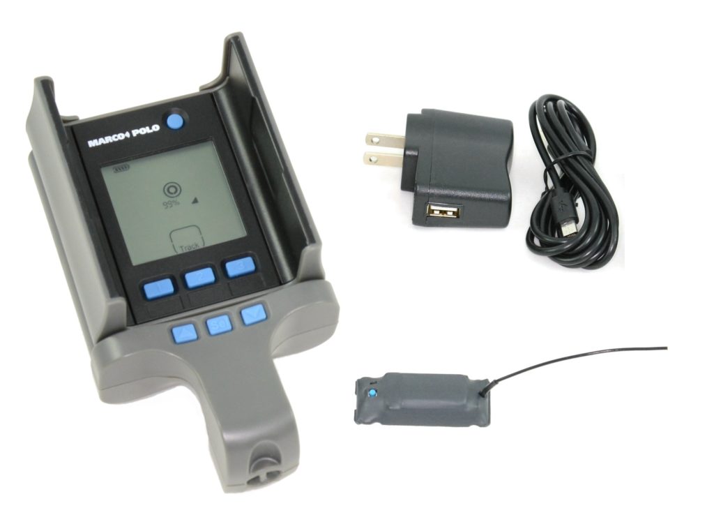
This won't help immediately, but if you get this drone back or replace it, use this to track if it gets lost:
I fly several drones, depending on the job, and have a patch of velcro stuck to the drone and one to the tracker so I can move it from drone to drone.
 
That's completely unnecessary and a waste of time.
It doesn't make your flying any safer.

It's very rare that anything but the default setting of RTH on loss of signal is appropriate

Unless you fly where a significant part of the skyview is blocked by buildings, terrain or tree cover, there will always be more than enough satellites in your sky.
So many that there's no risk of them all being bunched together.
GPS is very reliable.

That's completely unnecessary and a waste of time.
It doesn't make your flying any safer.
Not completely unnecessary, or a waste of time. Calibrating the compass can make the flight safer. See the flowing link:


It's very rare that anything but the default setting of RTH on loss of signal is appropriate
I fly where there is hundreds of feet of topographic relief, tall trees and/or buildings. RTH altitude and direction is almost always a necessary part of my flight planning.
Unless you fly where a significant part of the skyview is blocked by buildings, terrain or tree cover, there will always be more than enough satellites in your sky.
So many that there's no risk of them all being bunched together.
See previous response.
GPS is very reliab
The GPS system can be very reliable, but not available all the time for the reasons you mention and others. The follow resources may be of interest:


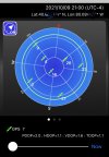
I also use an app on my iPhone called GPS Plan, which lets me check projected satellite position and estimate if the hills, etc in my flying environment might cause problems during a flight. See the attached photo for a screen shot of the app showing 7 satellites above “the horizon” but only three I might see at my current location, which is surrounded by 300-ft hills with peaks close enough to me that the sky below 45-deg is obscured.

Where I fly, I frequently have to wait for enough GPS satellites to be visible to fly with them.

None of what I suggest is hard to do, time consuming, or a waste of time for me.
 

Attachments

  • 34AB9707-A722-4CC1-830B-241E2D2B962B.jpeg
    34AB9707-A722-4CC1-830B-241E2D2B962B.jpeg
    935.1 KB · Views: 3
This won't help immediately, but if you get this drone back or replace it, use this to track if it gets lost:
I fly several drones, depending on the job, and have a patch of velcro stuck to the drone and one to the tracker so I can move it from drone to drone.
I also use the device you suggest. It’s a little expensive, but works great. I’ve tried using cellphone and Bluetooth tags and trackers, but none work as well. If you have or get the Marco Polo RF tracking system, practice with it before you need it.
 
Last edited:

DJI Drone Deals

New Threads

Forum statistics

Threads
135,473
Messages
1,606,501
Members
163,917
Latest member
AirDove
Want to Remove this Ad? Simply login or create a free account