I knew someone would say that, but with many years on a flight deck, skydiver and to fly a drone in this area almost everyday I can assure you around ~250ft, 300 ft tops
It's getting more current here as well. The Army has thousand of acres to train an hour from here but yet they like to rattle my windows on a small private farm regularly.
It seems to me that it would be a good idea when the military is doing low level flights in the U.S. they should be required to turn on transponders to make them show up on apps like flightradar24. At least a drone driver could check for low level flights in the area. I realize that the training aircraft would be here and gone in a short time, but at least it would be possible to predict their flight path for a little while. Or maybe there would be someway to display it on the drone controller realtime.
I knew someone would say that, but with many years on a flight deck, skydiver and to fly a drone in this area almost everyday I can assure you around ~250ft, 300 ft tops
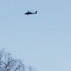
It's easy enough to determine range from your photograph if you know the camera FOV and image resolution. A UH-60 is 50 ft long and, for example, if that was a typical 12 MP phone camera with a FOV of 75° looking upwards at around 45°, then that helicopter was approximately 770 ft away and around 550 ft AGL.
It's easy enough to determine range from your photograph if you know the camera FOV and image resolution. A UH-60 is 50 ft long and, for example, if that was a typical 12 MP phone camera with a FOV of 75° looking upwards at around 45°, then that helicopter was approximately 770 ft away and around 550 ft AGL.
I track aircraft and helos all the time on Flight Radar to get a general idea of altitudes from my POV. Military ac do not show up on FR24 but I honestly thought this thing was about land in my field. Wasn't just a quick flyover but several very low circles. Just a very odd occurrence and only minutes from just flying my MP in the same airspace, again, over privately owned farm land.
I love this discussion. It is wonderful that we can all take any stance we want and argue the merits of our position.
YOU REMEMBER THIS: Those helicopters are the reason you can say what you want.
I track aircraft and helos all the time on Flight Radar to get a general idea of altitudes from my POV. Military ac do not show up on FR24 but I honestly thought this thing was about land in my field. Wasn't just a quick flyover but several very low circles. Just a very odd occurrence and only minutes from just flying my MP in the same airspace, again, over privately owned farm land.
There's not much you can do other than stay alert while flying and be prepared to descend if this kind of thing happens. Do you think they were looking for something?
There's not much you can do other than stay alert while flying and be prepared to descend if this kind of thing happens. Do you think they were looking for something?
This site uses cookies to help personalise content, tailor your experience and to keep you logged in if you register.
By continuing to use this site, you are consenting to our use of cookies.