DJI Mavic, Air and Mini Drones
Friendly, Helpful & Knowledgeable Community
Join Us Now

FAA sUAS 400’ AGL Requirement

Fine....now let's add 3 oz.. ADS-B to the equation after 2020 and we are reaching for .5 lbs approximately....
Last time I asked Google Assistant 35 grams is 1.2 ounces... I’m not sure how you ended up equating that to a half pound which is 6.67 times more...
 
Got some better ideas about using any discretionary payload capabilities:
77289
 
Just wondering why DJI can’t find a way to show me, at least “in general”, what the AGL altitude of my drone is. Seems like it shouldn’t be all that difficult. Knowing the altitude at my takeoff point doesn’t help at all for me to stay within the 400’ AGL limit.
If you want a "general" altitude of where you are just go to wiki and look up the town you are in and the elevation is usually there. I think there are some free apps that will give you a "general" altitude also.
 
My wrist watch is a Suunto Vector and it has built in altimeter, temperature, compass, rate of climb, etc. It could be done for altimetry but radar altimeter is another bigger problem as pointed out here. It seems to me that the proximity sensor on the bottom might be a possibility? Weight is a big issue. Also my smart controller screen is already too small for me to practically use the functions while flying with large, dry fingers.
 
The fact that we are limited to LOS operations, estimating the altitude of your AC within your flight range based on your launch point should not be a problem. A simple map reconnaissance should provide you with a good start.
You must be someone who lives in the flat lands. It is very different when flying in the mountains to know what terrain and its height you are flying over at any given time!!
 
  • Like
Reactions: Drgnfli
My recommendation, would be to get a topographic map of the area before flying. Know the terrain for the area and set your height limit 400 ft above the average height of the peaks.
 
You must be someone who lives in the flat lands. It is very different when flying in the mountains to know what terrain and its height you are flying over at any given time!!

No actually, Colorado front range,
 
No actually, Colorado front range,
It would've helped if I actually read the rest of your comment regarding map reconnaissance. I saw your statement about "estimating the altitude of your AC within your flight range based on your launch point" and reacted to just that part of your comment. I'll read the entire comment before reacting next time.

I'm a bit peeved about the whole altitude height issue myself. As a photographer, recovering from a broken leg, I purchased a drone to fly above hills that I could not climb last spring to shoot a super bloom of flowers. Where the best display of flowers were found at the higher altitudes. Default height restrictions was in place the first weekend I flew, and I couldn't get the drone to fly high enough over the hills that I wanted to photograph. Probably was my 2nd actual flight ever with my new drone. Round trip is about 6 hours to the location so I could only go on the weekends. I went home, studied, discovered how to allow the drone to fly higher than default, set the height limit to be 400 ft. above the average peak of the location and went back the next weekend. Only to find that it was then past peak bloom and I didn't get the photo that I wanted, UGH! Which was the whole reason I purchased a Mavic 2 Pro in the first place.

So sorry about my quick response, your right, map reconnaissance is good advice for hilly terrains. :)
 
  • Like
Reactions: tleedom
Just wondering why DJI can’t find a way to show me, at least “in general”, what the AGL altitude of my drone is. Seems like it shouldn’t be all that difficult. Knowing the altitude at my takeoff point doesn’t help at all for me to stay within the 400’ AGL limit.

Simple...all the app has to do is compare altitude of the drone to the elevation of the ground below it using free elevation data...same data Google Earth displays when you move your mouse around the map.

It really is amazing to me, what with DJI being so **** about safety, that the AGL altitude isn't displayed.
 
  • Like
Reactions: Drgnfli
:);):rolleyes::) Should I really post this? I will never live this post down.
[/QUOTE]
Nope, you wont. I was lost after the first sentence on how that even applies to the overlay map question.
 
Last edited:
Joe...yeah...you are totally wrong. :)

All DJI has to do is have a local elevation map on a pilot's phone (or stored onboard the drone using a bit of memory), and compare the height/location of the drone against that map, and then display the altitude difference.

That weighs nothing and costs nothing (besides a few hours of a DJI programmer's time).

--

Bill

Start by studying classical physics. Take at least three semesters of college physics. Then take at least of two years of college electrical engineering courses. Don't forget the three semesters of college mathematics just to understand the above. Then take at least two years of college software programming courses. Once you have a little background, then use that knowledge to try to figure out how to measure AGL from a flying device without adding more than 3 ounces to the aircraft. Don't forget the programming effort to provide the firmware to run the AGL system hardware.

Another way to do this would be to disassemble your smart phone, one system at a time and understand exactly how each system in your phone works. The easiest system to start with would be the battery charging system, and once that is understood move on to the microphone and speaker, and then how the analog audio system becomes digital, and then you have one small scratch on understanding your phone.

Of course that is all poking fun so smile, I am. Anyway just ask yourself what would be my first step to overlay a map. For example where would I get the map data, How much would it weight, or if I downloaded it live what receiver would I need. Who would transmit it to me just when I needed it?

Oh well you get my point. I hope your smiling. It's all in fun, but I am trying make the point that we all would benefit if more people would try to understand more details of how our drone stuff works. I wish the public schools would really teach, and not preach.

There is never a dumb question as long as one tries to understand the answer.

:);):rolleyes::) Should I really post this? I will never live this post down.
 
  • Like
Reactions: razoraerial and okw
Joe...yeah...you are totally wrong. :)

All DJI has to do is have a local elevation map on a pilot's phone (or stored onboard the drone using a bit of memory), and compare the height/location of the drone against that map, and then display the altitude difference.

That weighs nothing and costs nothing (besides a few hours of a DJI programmer's time).

--

Bill

Using gps altitude? Gps altitude is only accurate to 10-20 meters, so you’re 400’ agl could easily be 350ish’ or maybe 450ish’ agl, maybe a bit more or less.

Of course what I’ve learned from YouTube videos is that 400’ agl and los rules are mainly optional anyways.
 
Using gps altitude? Gps altitude is only accurate to 10-20 meters, so you’re 400’ agl could easily be 350ish’ or maybe 450ish’ agl, maybe a bit more or less.

Of course what I’ve learned from YouTube videos is that 400’ agl and los rules are mainly optional anyways.
My understanding is that the Mavics also use a barometric altimeter to calculate height above the take-off point, which has a much higher accuracy. I'd agree with @wsalopek that there shouldn't be any need to put anything at all in the aircraft to estimate the height AGL. Just download the DEM for your area before you fly.

I would also guess that even at +/- 50', as in your example, you'd still be fine with the authorities, since they wouldn't be able to tell any more accurately than that how high you are.
 
Using gps altitude? Gps altitude is only accurate to 10-20 meters, so you’re 400’ agl could easily be 350ish’ or maybe 450ish’ agl, maybe a bit more or less.

Of course what I’ve learned from YouTube videos is that 400’ agl and los rules are mainly optional anyways.

I'd think GPS altitude would be good enough (unless something REALLY bad happens...and even then, as long as you weren't acting recklessly, I doubt the FAA would prosecute)...and a person could choose 350 feet or so just to be safe.

But there's no reason the drone can't use its barometer, so that would be the obvious choice.

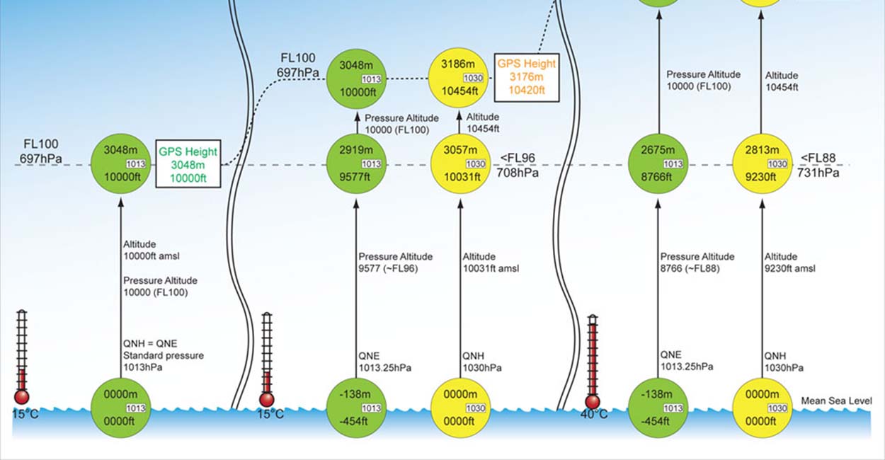
Interesting article here on altitude:

 
My understanding is that the Mavics also use a barometric altimeter to calculate height above the take-off point, which has a much higher accuracy. I'd agree with @wsalopek that there shouldn't be any need to put anything at all in the aircraft to estimate the height AGL. Just download the DEM for your area before you fly.

I would also guess that even at +/- 50', as in your example, you'd still be fine with the authorities, since they wouldn't be able to tell any more accurately than that how high you are.

I suspect that they would use barometric altitude relative to the takeoff elevation - the problem is that there is no guarantee that the takeoff elevation corresponds with the ground elevation in the DEM. Realistically, even 30 m DEMs would be hundreds of GB if incorporated into the firmware, and so they are not going to resolve most structure heights. GPS altitude AMSL is going to be the most accurate absolute elevation measurement, even if only used to set the takeoff elevation.
 
You also have to consider that DJI probably pays royalties for the existing map data. It would cost more to include topographical data.
 
I suspect that they would use barometric altitude relative to the takeoff elevation - the problem is that there is no guarantee that the takeoff elevation corresponds with the ground elevation in the DEM. Realistically, even 30 m DEMs would be hundreds of GB if incorporated into the firmware, and so they are not going to resolve most structure heights. GPS altitude AMSL is going to be the most accurate absolute elevation measurement, even if only used to set the takeoff elevation.

I'd think they'd implement it so that just the immediate area around the flight is downloaded/used...and that should make the file sizes quite manageable.

And as far as the cost goes, they look to be free in the U.S. from the USGS...

 
I suspect that they would use barometric altitude relative to the takeoff elevation - the problem is that there is no guarantee that the takeoff elevation corresponds with the ground elevation in the DEM. Realistically, even 30 m DEMs would be hundreds of GB if incorporated into the firmware, and so they are not going to resolve most structure heights. GPS altitude AMSL is going to be the most accurate absolute elevation measurement, even if only used to set the takeoff elevation.
How often would you suspect people are taking off from locations that are at a significantly different elevation than ground level? I've heard of people taking off from the roof of a building, or maybe the balcony of a hotel at the beach, but that seems quite rare to me. You could always compare the GPS data to the DEM value for the take-off location and ask the user for confirmation if there's a discrepancy.

Honestly, I'm not at all familiar with DEMs and how accurate the data is. I just guessed that there might be a way to download only a portion of the data, similar to the way an Android user can download portions of the Google map data, without the need to store hundreds of GB of information. And I would store all of the data and do all of the calculations on the users device, rather than in the aircraft or the RC.

But then again, I am only looking at this as a (far from expert) semi-pro programmer. And things always seem to get more complicated once you start writing code. :confused:
 
  • Like
Reactions: Drgnfli

DJI Drone Deals

New Threads

Members online

Forum statistics

Threads
131,641
Messages
1,564,819
Members
160,510
Latest member
pilot74sparki