


You are using an out of date browser. It may not display this or other websites correctly.
You should upgrade or use an alternative browser.
You should upgrade or use an alternative browser.
Hanger 360
- Thread starter SpaMavicPro
- Start date
Is it as easy to do on litchi like hanger 360?Litchi YES. Go No.
Absolutely Not. Heaps more work with Litchi but the results can be quite a bit better.Is it as easy to do on litchi like hanger 360?
Kestrel
Well-Known Member
You have to stitch the images yourself if you use litchi.Is it as easy to do on litchi like hanger 360?
macinfosys
Well-Known Member
I was playing around and did some research and it looks like others have used PTGui to stitch the Litchi images. All automated but have a lot of flexibility if needed. And the quality is much higher than Hanger 360. BUT Hanger 360 creates no brainier 360 image with minimal effort as long as quality that you are seeing here is good for your end result.
I think both have their place depending on what you are looking for at that point in time. I can see myself doing a QUICK Hanger shot to slap into Facebook or some sort of social media site and then using Litchi at times when I want something that is more permanent and of higher quality.
I think both have their place depending on what you are looking for at that point in time. I can see myself doing a QUICK Hanger shot to slap into Facebook or some sort of social media site and then using Litchi at times when I want something that is more permanent and of higher quality.

Kestrel
Well-Known Member
$87 dollars for a stitching program though sheesh.I was playing around and did some research and it looks like others have used PTGui to stitch the Litchi images. All automated but have a lot of flexibility if needed. And the quality is much higher than Hanger 360. BUT Hanger 360 creates no brainier 360 image with minimal effort as long as quality that you are seeing here is good for your end result.
I think both have their place depending on what you are looking for at that point in time. I can see myself doing a QUICK Hanger shot to slap into Facebook or some sort of social media site and then using Litchi at times when I want something that is more permanent and of higher quality.
As mentioned earlier, ive used it for a couple of weeks, ive never uploaded to Hangar servers instead chosen to use the hi res images from the sd card in Microsoft ICE to stitch

The 360 stuff does not look all that bad, it seems like a nice sharing tool. I often wonder when I look at this stuff and think "Are we providing these companies with great map data for free"")
If we really do have a million drones flying around by the end of the year they could feasibly get maybe 20-30% of the interesting land masses mapped for free with websites like this, assuming it becomes popular enough! That translates into 10's of millions of dollars that Google would spend doing it the hard way and these guys get it for almost free and they get a lot better images.
I would say its a very smart move on their part.
Rob
Kai Mele
Well-Known Member
How do you leave the app if you don't want to land immediately after taking the 360 photos?
It gives you the option to land or continue flying, you can fly while in the app or open DJI go to take over
rustydiver
Well-Known Member
Kai Mele
Well-Known Member
Thank you for explaining.It gives you the option to land or continue flying, you can fly while in the app or open DJI go to take over
Kestrel
Well-Known Member
I tried it at 150 feet and it failed to process. On the website it recommends 300 feet if you go lower they state it might not stitch.So what do people think is the ideal height to stop at?
Racenviper
Well-Known Member
- Joined
- Jan 22, 2017
- Messages
- 91
- Reactions
- 65
300 ft reduces the chance of parallax problems. It can only be solved by spinning the lens on the nodal point.
Racenviper
Well-Known Member
- Joined
- Jan 22, 2017
- Messages
- 91
- Reactions
- 65
Curious, what is the size of the file in pixels? I create my own in PTGui the images files are in the range of 19396 x 9698
sdharris
Well-Known Member
- Joined
- Oct 12, 2016
- Messages
- 284
- Reactions
- 106
- Age
- 49
So does litchi or GO have this 360 feature?
GO does not have any automated 360 option which is surprising, even Yuneec have implemented 360 panorama with the Typhoon H. Litchi has an option to take 360 images with customisation around the number of images per row and I believe an option to change the exposure for when the camera is facing the ground. But Litchi does not have the ability to upload and process images in the way Hangar 360 does.
JoostGT3
Well-Known Member
- Joined
- Apr 11, 2017
- Messages
- 865
- Reactions
- 679
- Age
- 45
Litchi does give you the option to take the pictures; It wants to know the angle of the total shot, the amount of photos in horizontal direction and the amount of photos in vertical direction. As a result you will have the photos; you'll have to do the stitching and uploading yourself.
As far as I know, the DJI Go app offers comparable options, but only a number of presets.
Regarding the stitching; there are some tutorials on youtube on how to do it (look for "stitching interactive panorama" or so), but in any case you will need some software to view the panoramas in an interactive way. Facebook can do it, Google maps can do it (not sure if the preparations for those platforms are the same!). Hangar 360 offers the entire stitching and uploading to their website and making it viewable/shareable as a service; all you do is fly to a point and hit "go".
Edit; oh sorry, just now saw the other reply ...
Robin
Well-Known Member
- Joined
- Oct 28, 2016
- Messages
- 409
- Reactions
- 157
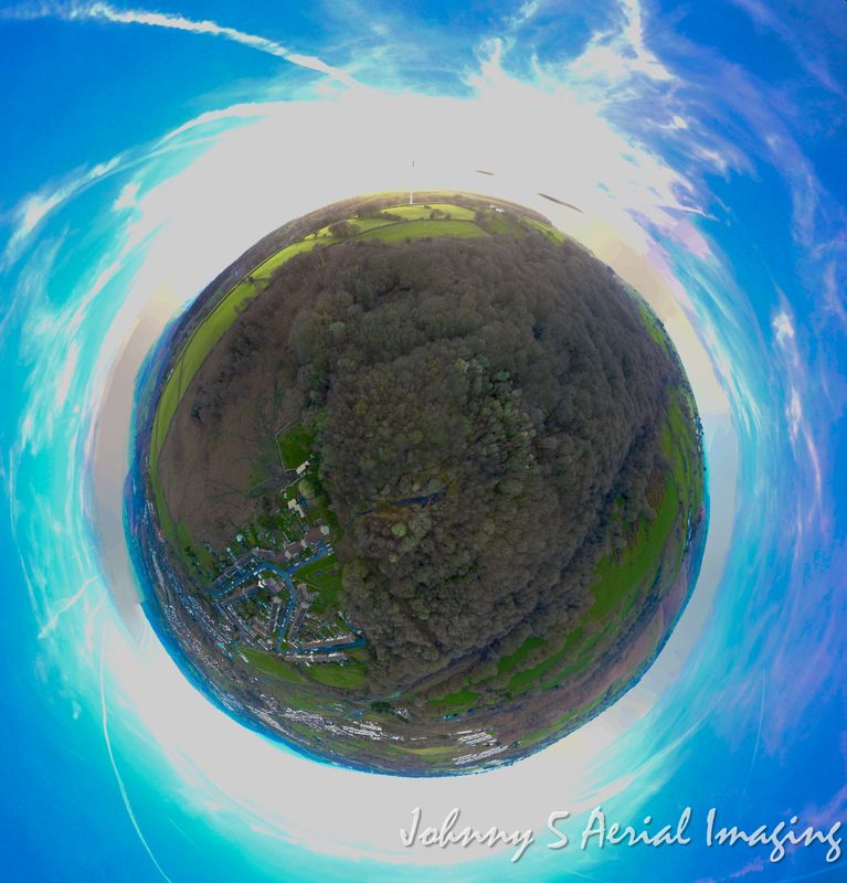
One I took this afternoon.
I was 30 m above the takeoff point in front of the church and I moved drone away from me before taking.
Hangar 360 Photo
I was 30 m above the takeoff point in front of the church and I moved drone away from me before taking.
Hangar 360 Photo
Kai Mele
Well-Known Member
Similar threads
- Replies
- 1
- Views
- 601
- Replies
- 2
- Views
- 425
- Replies
- 5
- Views
- 2K
- Replies
- 4
- Views
- 912


DJI Drone Deals
New Threads
-

-
-
Lost drone: possible crash due to lost signal?
- Started by fharrihill
- Replies: 4
-

-
 Last Week's Most Popular Topics (January 31, 2026)
- Started by msinger
- Replies: 0
Members online
Total: 4,481 (members: 11, guests: 4,470)
Forum statistics
