DJI Mavic, Air and Mini Drones
Friendly, Helpful & Knowledgeable Community
Join Us Now

Lost Mavic, different last known coordinates from "Find My Drone" and txt-file...

MBX Mavic

New Member
Joined
Jul 6, 2017
Messages
2
Reactions
3
Age
43
Location
Sweden
Hi!

I try to find a lost Mavic Pro, but when I look at the last known coordinates for the drone in "Find my Drone" and from the txt-file I get completely different results.

Here is the flight data from the txt-file:
DJI Flight Log Viewer - PhantomHelp.com
or here:
2018-05-09 18:40:38 | General / Overview | Drone Flight Log from DJI GO app, version 4.2.4 on iOS | Total Mileage: 6,704 ft | Sweden | Airdata UAV

By this data the drone seems to have drifted away, but the at the same time the travel speed seems to have been quite low.

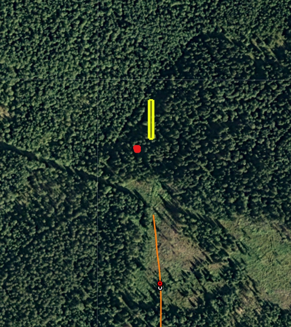
Here is the last known coordinates according to "Find my drone":
Google Maps

It is about 1,85km between the two locations.

When I look att the flight in DJI Go4 flight record, I do not have the "fly away"/drift that the txt-file is showing.

Why do I get different results, and which result is the correct one?
Thankful for any help!

Best regards,
Martin
 
I get about 63°59'7.86"N 15°22'52.09"E

The AC went into Atti mode due to a 'massive yaw error'.
 
I honestly don’t know what to tell you. After looking through the fight log, your bird was going “Zero mph” yet still traveled a 100’ and more within a few seconds. This instance happened quite often too. Not to mention the “yaw error” for most of the flight.
I’m still learning how to use the flight logs but with math, numbers don’t lie. Something strange with the birds behavior. Noticed it was in ATTI mode as well.
Let’s hope a more experienced pilot here in the forum might chime in.

Worst case scenario, get out the calculator and protractor. Gonna need to use some trig and calculus to find a search area. Possibly two areas but at least you can narrow it down.
 
You took off with 50% battery and flew 2km away? It was never going to end well.
When in ATTI mode, I dont think GPS would be too accurate.
 
You took off with 50% battery and flew 2km away? It was never going to end well.
When in ATTI mode, I dont think GPS would be too accurate.

RayOZ is right without GPS last known coordinates wont be accurate :( from the log file you posted ( air data link) there was wind not sure how much at the height you was at but also KP was 4 to that day = Kp of 4 to 6 May experience minor GPS issues :(

did you see any warning on the screen when you was flying? although I have experience GPS lost and the Mavic does drift bad and fast and can be hard to control when it does this :(
 
Hey Guys, I disagree?? Gps HEALTH caused the AC to go into Atti, which was some form of Yaw issue I think?. It still had a whole host of sats so I'm thinking that the last known position should be close??
We need someone with more experience to advise. @sar104 !!
 
Hey Guys, I disagree?? Gps HEALTH caused the AC to go into Atti, which was some form of Yaw issue I think?. It still had a whole host of sats so I'm thinking that the last known position should be close??
We need someone with more experience to advise. @sar104 !!

hum when its in atti mode there is no gps don't matter how it got to atti mode there still no gps hence the atti mode? however I never verified when in this condition if the last known coordinates would be accurate :( i am not sure how it could be without gps?? but I could be wrong?

ya he is the one to ask :)
 
  • Like
Reactions: Simmo
The "Find my drone" coordinate looks like the home point. The coordinate Simmo gave in #2 might be more accurate.

ahh ok let us know how close it was when you find it :)
 
You can ignore all the speed data after 310 seconds - that's not meaningful. In ATTI mode (entered due to compass errors) it was drifting steadily north with the wind at between 5 - 10 m/s:

2018-05-09_[18-40-37]_02.png

When it reached the critical low battery level at 570.5 seconds it initiated autoland and began to descend. The ground elevation at that location was around 10 m lower than the takeoff point, so extrapolating altitude downwards, and assuming that it will have landed on the ground (- 10 m) or hit a tree (estimating + 10 m) we can estimated how far further from the last recorded point it might have travelled.

2018-05-09_[18-40-37]_01.png

That gives between 75 m and 115 m north, and between 8 m and 12 m west. On Google Earth, that is shown by the yellow box below:

screenshot140.jpg
 
Last edited:
You can ignore all the speed data after 310 seconds - that's not meaningful. In ATTI mode (entered due to compass errors)
it was drifting steadily north with the wind at between 5 - 10 m/s:

View attachment 38698

When it reached the critical low battery level at 570.5 seconds it initiated autoland and began to descend. The ground elevation at that location was around 10 m lower than the takeoff point, so extrapolating altitude downwards, and assuming that it will have landed on the ground (- 10 m) or hit a tree (estimating + 10 m) we can estimated how far further from the last recorded point it might have travelled.

View attachment 38699

That gives between 75 m and 115 m north, and between 8 m and 12 m west. On Google Earth, that is shown by the yellow box below:

View attachment 38700
wow incredible job decivering this, wow hope he finds it,
 
hum when its in atti mode there is no gps don't matter how it got to atti mode there still no gps hence the atti mode? however I never verified when in this condition if the last known coordinates would be accurate :( i am not sure how it could be without gps?? but I could be wrong?

ya he is the one to ask :)

That's not correct. The fact that the FC switched to ATTI mode does not mean that there is any problem with the GPS data - just that the IMU fusion scheme has failed. In this case that was due to discrepancies between the IMU-computed yaw and the compass reading. The GPS data were fine, with 18 - 21 satellites locked for the latter part of the flight.
 
That's not correct. The fact that the FC switched to ATTI mode does not mean that there is any problem with the GPS data - just that the IMU fusion scheme has failed. In this case that was due to discrepancies between the IMU-computed yaw and the compass reading. The GPS data were fine, with 18 - 21 satellites locked for the latter part of the flight.

So am I somewhat correct with my interpretation in #6?
I'm thinking of Gps Health as a lot more than its name suggests??
 
So am I somewhat correct with my interpretation in #6?
I'm thinking of Gps Health as a lot more than its name suggests??

Yes. GPS health is a misnomer - it is really a measure of the correspondence between the GPS location data and the IMU-computed motion of the aircraft. It can decrease due to poor GPS data or due to IMU problems, such as a discrepancy between the expected direction of travel and the actual track caused by a yaw error.
 
If the last few moment had good GPS, why did the "Find my Drone" point to closer to home? I assume KP index of 4 might affect GPS. Would it affect Compass/IMU?
 
If the last few moment had good GPS, why did the "Find my Drone" point to closer to home? I assume KP index of 4 might affect GPS. Would it affect Compass/IMU?

Even at that latitude, the KP index is not a factor. Significant magnetic storms can marginally affect the propagation paths in the ionosphere, but the difference that it will make to the GPS solution with that many satellites is unimportant. And it will have no effect at all on the compass or IMU.

The "Find my drone" location was simply the location when the aircraft switched to ATTI - i.e. before it began to drift.
 
  • Like
Reactions: Simmo and laurens23
I FOUND THE BIRD! :) I found it on the ground, and it was fine, except for some moisture inside it due to some rain during those 16 days it was waiting for me.
Thank you all for your inputs, and especially to sar104 for that profound explanation of the possible landing point! You deserve a gold star!
The red dot in the picture is the place where i found it, so sar104 was very close with the yellow lines:

Thanks for the follow up information and I'm glad that you found it. In hindsight I'm not surprised by the location. Firstly, we should expect the wind speed to drop nearer the ground, meaning less drift. Secondly, the drift was swinging slightly more westerly right at the end as you can see on the aerial image and the velocity graph. In this case a linear extrapolation wasn't the best strategy - I'll pay more attention to that next time. I thought after I posted that the flight path wasn't quite pointing at the predicted location, but I figured that you would check out that area anyway.
 
  • Like
Reactions: MBX Mavic
Lycus Tech Mavic Air 3 Case

DJI Drone Deals

New Threads

Forum statistics

Threads
130,592
Messages
1,554,178
Members
159,596
Latest member
da4o98