No rush ... sometime next week (or never) will be fine.Thanks, got it I’ll download the data and post it tomorrow. Thanks again.
You are using an out of date browser. It may not display this or other websites correctly.
You should upgrade or use an alternative browser.
You should upgrade or use an alternative browser.
Lost my Drone,
- Thread starter NeilRob
- Start date

I wonder about the accuracy of some of your statements (if not all).
"there is no reason why I should have lost signal as there were no obstructions."
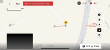
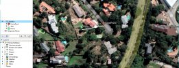
The HomePoint is surrounded by nearby trees and buildings, particularly in the direction you were flying.

"unfortunately it was 48 Mrs away from me in the inaccessible valley in a tree!!!!"
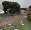
A tree in a backyard only 48m away and 11m uphill doesn't look like an 'inaccessible valley' to me.

It went down on the other side not the upper side. There one house and the then the valley where I went down.View attachment 151064
I wonder about the accuracy of some of your statements (if not all).
"there is no reason why I should have lost signal as there were no obstructions."
The HomePoint is surrounded by nearby trees and buildings, particularly in the direction you were flying.
View attachment 151065
"unfortunately it was 48 Mrs away from me in the inaccessible valley in a tree!!!!"
A tree in a backyard only 48m away and 11m uphill doesn't look like an 'inaccessible valley' to me.
View attachment 151066
NeilRob,
I do not think you should post on this thread again unless it is to provide your Logs or to ask for further elaboration on how to access and/or post your logs.
These gentlemen are willing to take their free time and then for free offer what is in my opinion a professional analysis of your unfortunate flight.
In the end, you will be more knowledgeable about your aircraft and possibly a better pilot.
If you need assistance Private Message me and I will help you to retrieve your logs.
Don't post that you will if you won't.Thanks appreciated. Will do.
I would have analysed your data in 10 minutes and given you a proper explanation of what it showed if you had done it earlier.
But you've just annoyed me with your asking how to post data multiple times and ignoring the help given and then posting that you would post data, but not bothering.
All I can deduce is that you are not really interested and just want to waste people's time.
Good luck working it out yourself.
- Joined
- May 25, 2017
- Messages
- 8,476
- Reactions
- 7,966
- Age
- 63
NeilRob,
I do not think you should post on this thread again unless it is to provide your Logs or to ask for further elaboration on how to access and/or post your logs.
These gentlemen are willing to take their free time and then for free offer what is in my opinion a professional analysis of your unfortunate flight.
In the end, you will be more knowledgeable about your aircraft and possibly a better pilot.
If you need assistance Private Message me and I will help you to retrieve your logs.
Good on you for your patience.
The OP possibly is not as tech literate as many . . . enough to find, save, and upload the txt flight log, so it it would be nice to get some extra assistance.
The phantomhelp page (linked again below) makes finding the flight log pretty simple though, not sure you could do a written assistance to help any better.
A phone call running through could help for sure, maybe you are in SA too and can do this.
If the OP follows this carefully, it should be do-able.
You will need a computer to connect the drone to (you may be able to do this on your device ?), the cable to connect them, you need to copy / save the txt file to your desktop or file, then upload that to the phantomhelp site up the top of the page as instructed.
DJI Flight Log Viewer | Phantom Help
Upload and view flight logs from your DJI drones
Good luck.
Hi Meta, I’m really sorry you feel that way, I fully intend to attach the data, however I have many other things that I have to do and will get around to it when I can. Thanks for your time anyway and if you’re still willing and able to analyse my data when I attach it I would very much appreciate it, if not I’m sorry if I’ve bothered you. Thanks again.Don't post that you will if you won't.
I would have analysed your data in 10 minutes and given you a proper explanation of what it showed if you had done it earlier.
But you've just annoyed me with your asking how to post data multiple times and ignoring the help given and then posting that you would post data, but not bothering.
All I can deduce is that you are not really interested and just want to waste people's time.
Good luck working it out yourself.
I probably won't be able to resist the challenge of solving the puzzle if/when you get around to posting flight data.Hi Meta, I’m really sorry you feel that way, I fully intend to attach the data, however I have many other things that I have to do and will get around to it when I can. Thanks for your time anyway and if you’re still willing and able to analyse my data when I attach it I would very much appreciate it, if not I’m sorry if I’ve bothered you. Thanks again.
Finding and posting the data should only take two minutes, maybe three the first time you do it.
Sorry this happened to you. It's usually best to provide as much detail as you can to this forum. What happened after you got the message? RC disconnected from mobile is different to being disconnected from the aircraft. It was close to you, did you try any commands? Did it respond? Upload your logs, there's usually someone on here that can work out what went wrong. I'd be trying real hard to recover it if you know where it is, it's probably minimally damaged.Still a very newbie and took my drone out for a fly, probably my 5th flight. I was flying at about altitude 50 mts was 48 mts away, when I got a red message “RC not connected to mobi… long and the short of the story, couldn’t communicate with the drone and eventually it landed in the trees in an inaccessibility area. Expensive mistake, what could I have done wrong and how do I prevent it from happening again.
The first time I got that message, it scared the [Language Removed by ADMIN] out of me. I thought I had lost my mavic 3. So I started walking toward the last position of the drone. No video of course. Finally, the video came back, and I was so happy. Usally no connection between remote and device means the cable is bad or slightly unplugged. But you're still connected to the drone. So just hit RTH and it should come back. You said you had video, but that seems impossible if the remote isn't connected to the device. Maybe you can locate it with another drone and figure out some way to retrieve it. Good luck!
Last edited by a moderator:
Hi again Meta, I’ve got the flight records. I’ve taken the liberty of sending you them all so the you can see how much of a newbie I am. I would be grateful for you assistance in identifying why I lost signal and had no control over the drone and could only bring it down in the inaccessible valley in bushes.I probably won't be able to resist the challenge of solving the puzzle if/when you get around to posting flight data.
Finding and posting the data should only take two minutes, maybe three the first time you do it.
I’ve bought a new one and really would value your advice. Thanks again. Neil
It went down on the other side not the upper side. There one house and the then the valley where I went down.
Hi again Meta, I’ve got the flight records. I’ve taken the liberty of sending you them all so the you can see how much of a newbie I am. I would be grateful for you assistance in identifying why I lost signal and had no control over the drone and could only bring it down in the inaccessible valley in bushes.
I’ve bought a new one and really would value your advice. Thanks again. Neil
Neko 506
Well-Known Member
I am eating through my fingernails in this one.
Just waiting for the analysis now, I love how the information is explained bit by bit, step by step, minute by minute.
Just waiting for the analysis now, I love how the information is explained bit by bit, step by step, minute by minute.
Yeah this one has built up some suspense.I am eating through my fingernails in this one.
Just waiting for the analysis now, I love how the information is explained bit by bit, step by step, minute by minute.
I actually read every one on this forum and Phantom Pilots, as I love to learn more about how flight mishaps happen to be able to better prevent them for the sUAS program I am in.
I actually used an analysis from here in an official accident report and after action report after I suffered a total aircraft loss on a mission. This information is used to brief any new pilots to factor in when on similar missions.
Here's what happened:Here’s the file.
You started the flight with good GPS and a good homepoint, flew back and forward around your starting point.
At 13:28 you received the first message about weak signal:
Weak signal. Make sure the remote controller is facing aircraft and avoid blocking the signal
As the drone was quite close, this could have been simply because there were enough trees between the controller and drone to reduce signal strength or you might not have kept the controller oriented towards the drone.
At 13:28, uplink signal strength dropped to zero
At 13:45.1 there was a number of signal-related messages at the same time:
Remote controller disconnected from aircraft (Code: 30029).; Remote controller signal weak. Adjust remote controller antennas (Code: 80002).; Remote controller signal lost.
At 13:45.8 Downlink (signal from the drone) was lost.
When signal was restored 23 seconds later, the drone was 25 metres higher and climbing to RTH height.
Uplink signal strength remained at zero or low numbers for about 1.5 minutes, but data continued to be recorded, showing the RTH proceding as programmed.
Good signal strength returned at 14:48.3, at the same time the drone reached a point directly above the homepoint and started to descend from 120 metres.
When the drone was descending and at 68 metres, you started to work the joysticks to fly away from the home point.
Working the joysticks while the drone is in RTH or Autolanding can be confusing, because the drone will try to continue with it's programmed flight.
If you want to resume control, you need to cancel the RTH or autolanding and then you won't be fighting against the programmed flight.
At 15:31.2 the drone came to rest about 20 metres higher than the home point, up in a tree, 39 metres from the homepoint. The height is only approximate.
The tree is shown in this image.
It looks small enough that you should have a good chance of finding it.

- Joined
- May 25, 2017
- Messages
- 8,476
- Reactions
- 7,966
- Age
- 63
Nice work @Meta4
One thing strikes me with these newer drones . . . signal strength / uplink weakness at times.
"Weak signal. Make sure the remote controller is facing aircraft and avoid blocking the signal
As the drone was quite close, this could have been simply because there were enough trees between the controller and drone to reduce signal strength or you might not have kept the controller oriented towards the drone."
I have flown my M1P (the first and original version of occusync) and Spark (which is only wifi), and never had issues with trees in the way, or reasonable distance, nor with facing any way I like while flying.
Mind you I keep reasonably close, say up to 500m - 600m most flights, but very often I'm flying around quite large Eucalyptus trees, sometimes old buildings, low and away some distance.
I do watch my signal meter and sometimes it gets lower, but never red / lost signal.
This is over some 5+ years, it makes me wonder how things seem to go backwards with some of these products.
I do like the older fold out antenna, as compared to thee newer fixed internal type, maybe convenience outweighs function to DJI designers.
- Joined
- May 25, 2017
- Messages
- 8,476
- Reactions
- 7,966
- Age
- 63
Similar threads
- Replies
- 10
- Views
- 3K
- Replies
- 68
- Views
- 2K
- Replies
- 106
- Views
- 5K
- Replies
- 28
- Views
- 5K
DJI Drone Deals
New Threads
-
-
-
Mini 3 Cumulonimbus Shots with the mini 3
- Started by Dan'sUavTech
- Replies: 2
-
-


